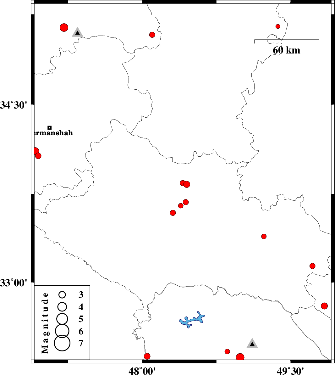
| Prel. Rep. | Date | Time(UTC) | Time(Local) | Lat. | Lon. | Depth | Mag. | Region | Waveform |
|
|
2012/11/23
|
01:01:23.6
|
04:31:23.6
| 33.83 | 48.45 | 17 |
ML:3
|
Lorestan Province, 14 km East of Aleshtar | |
|
|
2012/11/23
|
00:26:12.6
|
03:56:12.6
| 33.84 | 48.41 | 15 |
ML:2.6
|
Lorestan Province, 10 km East of Aleshtar | |
|
|
2012/11/20
|
15:19:38.3
|
18:49:38.3
| 34.07 | 46.95 | 14 |
ML:2.7
|
Kermanshah Province, 29 km South-West of Kermanshah | |
|
|
2012/11/20
|
10:05:05.7
|
13:35:05.7
| 34.11 | 46.92 | 15 |
ML:3.2
|
Kermanshah Province, 30 km East of Eslam Abad-E-Gharb | |
|
|
2012/11/19
|
15:41:47.6
|
19:11:47.6
| 32.37 | 48.05 | 18 |
ML:2.8
|
Khoozestan Province, 33 km West of Dezful | |
|
|
2012/11/16
|
18:21:56.7
|
21:51:56.7
| 33.39 | 49.23 | 14 |
ML:2.2
|
Lorestan Province, 18 km East of Dorud | |
|
|
2012/11/16
|
14:54:30.7
|
18:24:30.7
| 32.41 | 48.86 | 14 |
ML:2.2
|
Khoozestan Province, 24 km West of Lali | |
|
|
2012/11/15
|
18:35:12.7
|
22:05:12.7
| 33.14 | 49.72 | 16 |
ML:2.6
|
Lorestan Province, 30 km South of Aligudarz | |
|
|
2012/11/10
|
16:17:30.0
|
19:47:30.0
| 33.59 | 48.31 | 18 |
ML:2.5
|
Lorestan Province, 12 km North of Khorramabad | |
|
|
2012/11/09
|
23:59:53.8
|
03:29:53.8
| 33.68 | 48.44 | 16 |
ML:2.5
|
Lorestan Province, 23 km North of Khorramabad | |
|
|
2012/11/09
|
23:55:52.5
|
03:25:52.5
| 33.65 | 48.39 | 18 |
ML:2.2
|
Lorestan Province, 19 km North of Khorramabad | |
|
|
2012/11/08
|
19:53:13.4
|
23:23:13.4
| 35.08 | 48.1 | 14 |
ML:2.5
|
Kurdistan Province, 34 km North of Asad Abad | |
|
|
2012/11/06
|
00:15:22.5
|
03:45:22.5
| 32.8 | 49.84 | 6 |
ML:3
|
Esfahan Province, 30 km South-West of Fereydunshahr | |
|
|
2012/11/05
|
18:02:34.8
|
21:32:34.8
| 32.36 | 48.99 | 34 |
ML:3.6
|
Khoozestan Province, 11 km West of Lali | |
|
|
2012/10/31
|
09:21:58.2
|
12:51:58.2
| 35.15 | 49.37 | 15 |
ML:2
|
Hamedan Province, 40 km South-East of Razan | |
|
|
2012/10/28
|
02:21:07.7
|
05:51:07.7
| 35.14 | 47.21 | 14 |
ML:3.6
|
Kurdistan Province, 28 km South-East of Sanandaj | |
