
Magnitude |
:3 |
| Date & Time (UTC) | 2012-11-23 01:01:23.6 |
| Date & Time (Local) | 1391/9/3 04:31:23.6 |
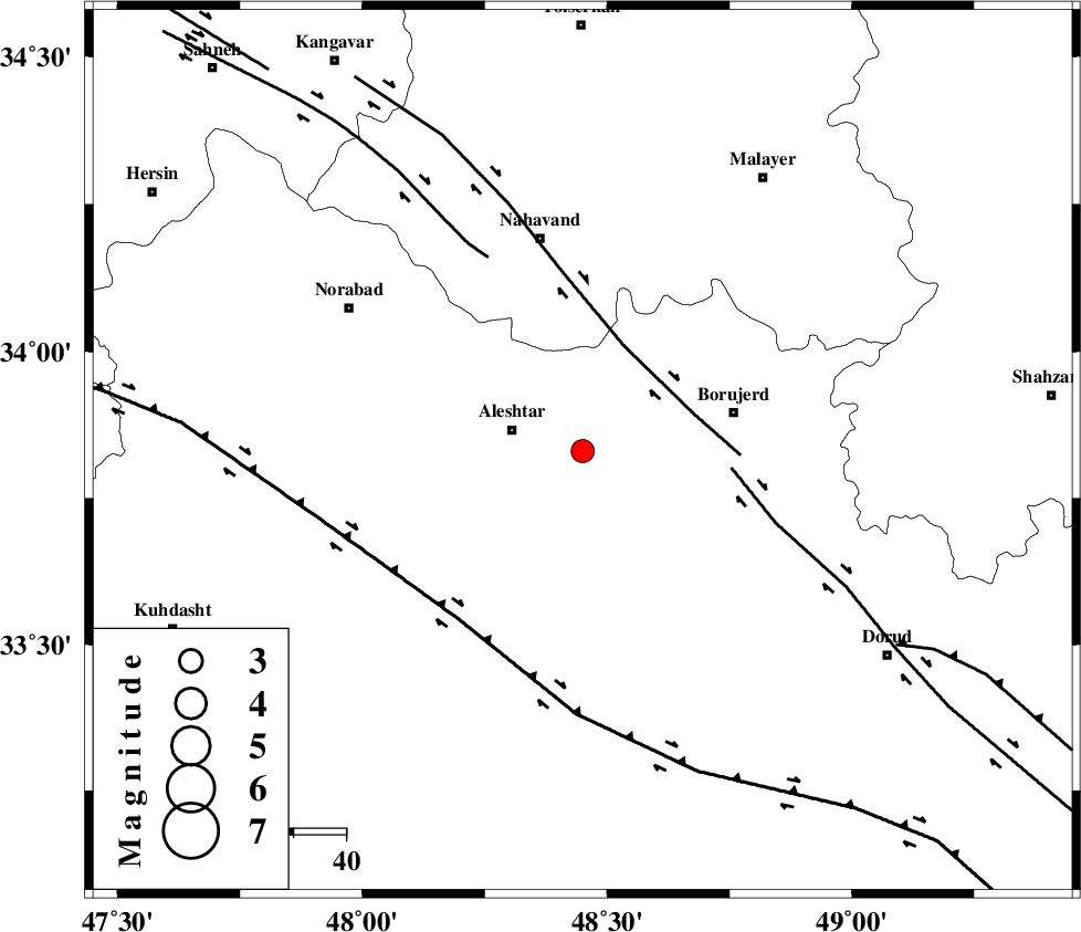
| Location | Lat:33.83 Lon: 48.45 |
| Region | Lorestan Province, 14 km East of Aleshtar |
Nearest Cities |
|
| 14 km East of Aleshtar, Lorestan Province | |
| 14 km North East of Siyahpush, Lorestan Province | |
| 17 km East of Dehrahim, Lorestan Province | |
| 19 km North West of Pellekan-e sofla, Lorestan Province | |
| 22 km North West of Cheharborji, Lorestan Province | |
| Depth | 17 km |
| Agency | |
Faults within 150 km: |
|
| NAHAVAND_F (Length: 102 km) , Distance to epicenter: 21 km | |
| DORUD (Length: 100 km) , Distance to epicenter: 28 km | |
| HZF4 (Length: 492 km) , Distance to epicenter: 40 km | |
| Number of Phases | 6 |
| RMS | 0.1 |
| Number of Stations | 5 |
| Error in Latitude | >1.9 km |
| Error in Longitude | 1.7 km |
| Error in Depth | 3.7 km |
Download waveform in seisan format
to download seisan software Click here
to access information about IIEES stations Click here
Amplitude | ||||||||
| UID | Agency | Station | Component | Amplitude | Period | Arrival Time | Proccessing Time | Signal Clip |
| 87125 | IIEES | SNGE | N | 150.9 | 0.8 | 2012-11-23 01:02:22 | 2012-11-23 07:07:00 | n |
| 87126 | IIEES | SHGR | E | 151 | 0.36 | 2012-11-23 01:02:22 | 2012-11-23 07:07:00 | n |
| 87127 | IIEES | SHGR | N | 191.9 | 0.4 | 2012-11-23 01:02:28 | 2012-11-23 07:07:00 | n |
Phase | ||||||||||||
| Agency | Station | Component | Phase Type | Phase Quality | First Motion | Observed Arrival Time | Time Residual | Loc. Flag | Input Weight | Distance | Azimuth | |
| IIEES | KHMZ | Z | Pg | E | 2012-11-23 01:01:47 | -0.13 | y | 141 | 93 | |||
| IIEES | ASAO | Z | Pg | E | 2012-11-23 01:01:51 | 0.06 | y | 166 | 61 | |||
| IIEES | ASAO | E | Sg | E | 2012-11-23 01:02:11 | 0.07 | y | 166 | 61 | |||
| IIEES | SNGE | Z | Pg | E | 2012-11-23 01:01:52 | 0 | y | 173 | 325 | |||
| IIEES | SHGR | Z | Pn | E | 2012-11-23 01:01:55 | 0.07 | y | 193 | 170 | |||
| IIEES | THKV | Z | Pn | E | 2012-11-23 01:02:11 | -0.08 | y | 321 | 43 | |||