
Magnitude |
:3.2 |
| Date & Time (UTC) | 2012-11-20 10:05:05.7 |
| Date & Time (Local) | 1391/8/30 13:35:05.7 |
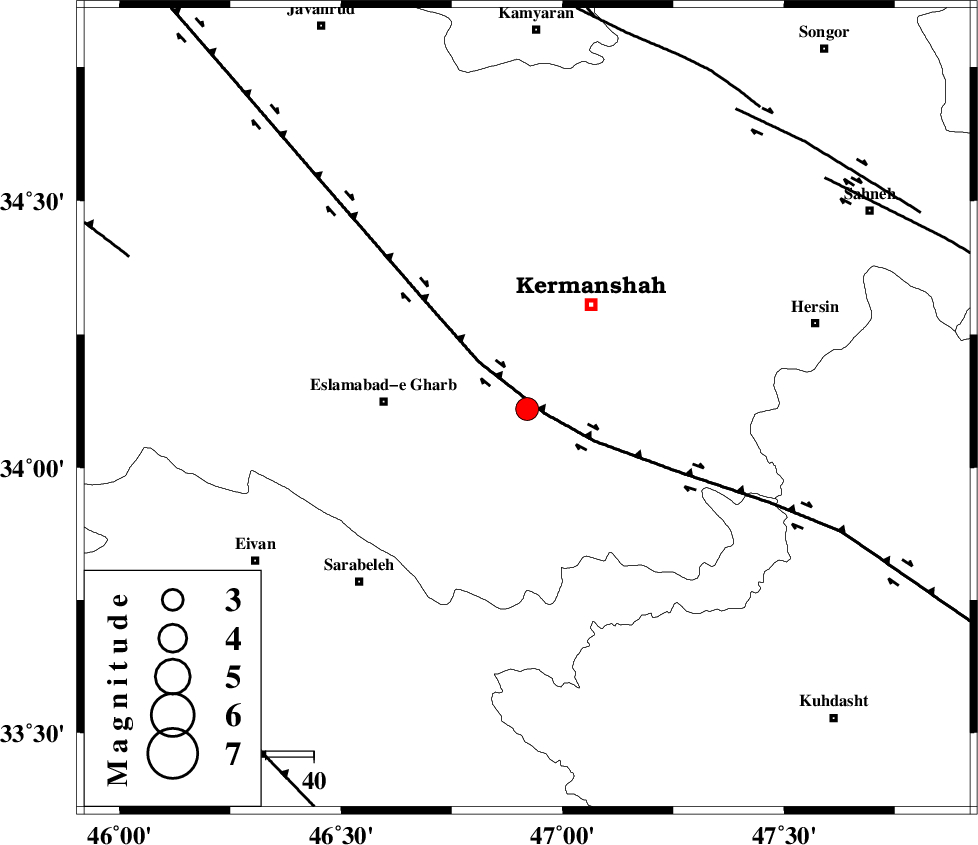
| Location | Lat:34.11 Lon: 46.92 |
| Region | Kermanshah Province, 30 km East of Eslam Abad-E-Gharb |
Nearest Cities |
|
| 8 km of Helshi, Kermanshah Province | |
| 21 km South East of Rebat, Kermanshah Province | |
| 21 km North East of Qale-ye shahin, Kermanshah Province | |
| 24 km North East of Hamil, Kermanshah Province | |
| 26 km South West of Kermanshah, Kermanshah Province | |
| Depth | 15 km |
| Agency | |
Faults within 150 km: |
|
| HZF4 (Length: 492 km) , Distance to epicenter: 4 km | |
| DINEHVAR_F (Length: 46 km) , Distance to epicenter: 76 km | |
| SAHANEH_F (Length: 77 km) , Distance to epicenter: 78 km | |
| Number of Phases | 5 |
| RMS | 0.3 |
| Number of Stations | 6 |
| Error in Latitude | >4.9 km |
| Error in Longitude | 6.9 km |
| Error in Depth | 0 km |
Download waveform in seisan format
to download seisan software Click here
to access information about IIEES stations Click here
Amplitude | ||||||||
| UID | Agency | Station | Component | Amplitude | Period | Arrival Time | Proccessing Time | Signal Clip |
| 87101 | IIEES | SNGE | N | 714.2 | 0.38 | 2012-11-20 10:05:52 | 2012-11-20 09:33:00 | n |
| 87102 | IIEES | SHGR | E | 110.8 | 0.62 | 2012-11-20 10:06:39 | 2012-11-20 09:33:00 | n |
| 87103 | IIEES | SHGR | N | 116.3 | 0.54 | 2012-11-20 10:06:43 | 2012-11-20 09:33:00 | n |
Phase | ||||||||||||
| Agency | Station | Component | Phase Type | Phase Quality | First Motion | Observed Arrival Time | Time Residual | Loc. Flag | Input Weight | Distance | Azimuth | |
| IIEES | SHGR | Z | Pn | E | 2012-11-20 10:05:48 | 0.14 | y | 283 | 141 | |||
| IIEES | KHMZ | Z | Pn | E | 2012-11-20 10:05:48 | -0.56 | y | 285 | 97 | |||
| IIEES | ASAO | Z | Pn | E | 2012-11-20 10:05:50 | 0.41 | y | 290 | 79 | |||
| IIEES | CHTH | Z | Pn | E | 2012-11-20 10:06:07 | 0.11 | y | 433 | 61 | |||
| IIEES | GRMI | Z | P | E | 2012-11-20 10:06:19 | -0.12 | y | 529 | 9 | |||