
Magnitude |
:3 |
| Date & Time (UTC) | 2012-11-06 00:15:22.5 |
| Date & Time (Local) | 1391/8/16 03:45:22.5 |
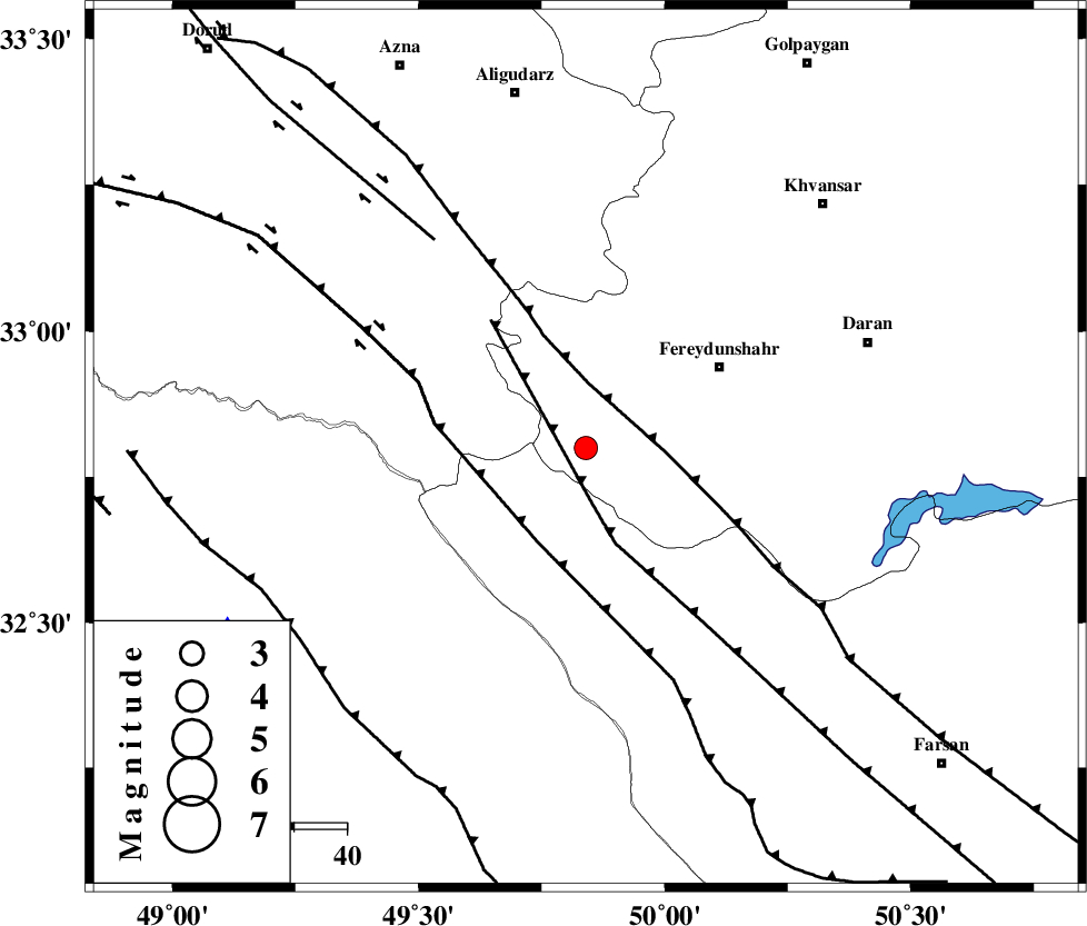
| Location | Lat:32.8 Lon: 49.84 |
| Region | Esfahan Province, 30 km South-West of Fereydunshahr |
Nearest Cities |
|
| 5 km of Masir, Esfahan Province | |
| 12 km North of Durak, Chaharmahal Bakhtiari Province | |
| 23 km West of Sibak, Esfahan Province | |
| 30 km South West of Fereydunshahr, Esfahan Province | |
| 32 km South of Farsesh, Lorestan Province | |
| Depth | 6 km |
| Agency | |
Faults within 150 km: |
|
| ARDAL_F (Length: 170 km) , Distance to epicenter: 10 km | |
| MAIN_ZAGROS_R_F (Length: 1106 km) , Distance to epicenter: 12 km | |
| ZARDKUH_F (Length: 139 km) , Distance to epicenter: 20 km | |
| Number of Phases | 5 |
| RMS | 0.3 |
| Number of Stations | 4 |
| Error in Latitude | >5.8 km |
| Error in Longitude | 8.7 km |
| Error in Depth | 7.3 km |
Download waveform in seisan format
to download seisan software Click here
to access information about IIEES stations Click here
Amplitude | ||||||||
| UID | Agency | Station | Component | Amplitude | Period | Arrival Time | Proccessing Time | Signal Clip |
| 86840 | IIEES | SHGR | N | 325.4 | 0.28 | 2012-11-06 00:16:02 | 2012-11-06 12:08:00 | n |
| 86841 | IIEES | SHGR | E | 291.4 | 0.32 | 2012-11-06 00:16:05 | 2012-11-06 12:08:00 | n |
Phase | ||||||||||||
| Agency | Station | Component | Phase Type | Phase Quality | First Motion | Observed Arrival Time | Time Residual | Loc. Flag | Input Weight | Distance | Azimuth | |
| IIEES | KHMZ | Z | Pg | E | 2012-11-06 00:15:40 | -0.21 | y | 105 | 7 | |||
| IIEES | SHGR | Z | Pg | E | 2012-11-06 00:15:43 | -0.46 | y | 124 | 232 | |||
| IIEES | SHGR | E | Sg | E | 2012-11-06 00:15:59 | 0.28 | y | 124 | 232 | |||
| IIEES | GHVR | Z | Pn | E | 2012-11-06 00:15:59 | 0.26 | y | 228 | 35 | |||
| IIEES | SNGE | Z | Pn | E | 2012-11-06 00:16:14 | 0.14 | y | 343 | 319 | |||