
Magnitude |
:2.6 |
| Date & Time (UTC) | 2012-11-23 00:26:12.6 |
| Date & Time (Local) | 1391/9/3 03:56:12.6 |
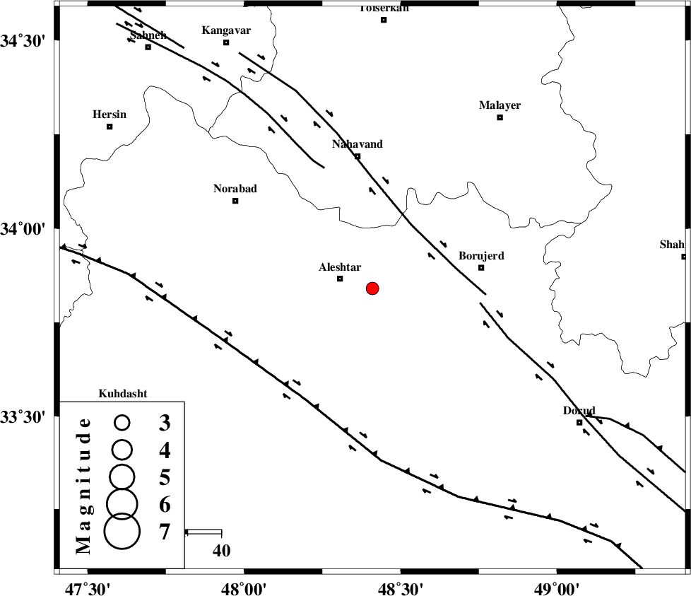
| Location | Lat:33.84 Lon: 48.41 |
| Region | Lorestan Province, 10 km East of Aleshtar |
Nearest Cities |
|
| 10 km East of Aleshtar, Lorestan Province | |
| 11 km North East of Siyahpush, Lorestan Province | |
| 13 km East of Dehrahim, Lorestan Province | |
| 23 km North West of Pellekan-e sofla, Lorestan Province | |
| 25 km North West of Cheharborji, Lorestan Province | |
| Depth | 15 km |
| Agency | |
Faults within 150 km: |
|
| NAHAVAND_F (Length: 102 km) , Distance to epicenter: 22 km | |
| DORUD (Length: 100 km) , Distance to epicenter: 32 km | |
| SAHANEH_F (Length: 77 km) , Distance to epicenter: 38 km | |
| Number of Phases | 5 |
| RMS | 0 |
| Number of Stations | 4 |
| Error in Latitude | >1.8 km |
| Error in Longitude | 3.9 km |
| Error in Depth | 7.8 km |
Download waveform in seisan format
to download seisan software Click here
to access information about IIEES stations Click here
Amplitude | ||||||||
| UID | Agency | Station | Component | Amplitude | Period | Arrival Time | Proccessing Time | Signal Clip |
| 87120 | IIEES | ASAO | E | 81.5 | 0.64 | 2012-11-23 00:27:05 | 2012-11-23 07:07:00 | n |
| 87121 | IIEES | SNGE | E | 62.8 | 0.56 | 2012-11-23 00:27:11 | 2012-11-23 07:07:00 | n |
| 87122 | IIEES | SNGE | N | 64.1 | 0.56 | 2012-11-23 00:27:12 | 2012-11-23 07:07:00 | n |
| 87123 | IIEES | SHGR | N | 104.4 | 0.44 | 2012-11-23 00:27:18 | 2012-11-23 07:07:00 | n |
| 87124 | IIEES | SHGR | E | 63.4 | 0.48 | 2012-11-23 00:27:21 | 2012-11-23 07:07:00 | n |
Phase | ||||||||||||
| Agency | Station | Component | Phase Type | Phase Quality | First Motion | Observed Arrival Time | Time Residual | Loc. Flag | Input Weight | Distance | Azimuth | |
| IIEES | KHMZ | Z | Pg | E | 2012-11-23 00:26:36 | -0.04 | y | 145 | 94 | |||
| IIEES | ASAO | Z | Pg | E | 2012-11-23 00:26:40 | 0.05 | y | 168 | 62 | |||
| IIEES | ASAO | E | Sg | E | 2012-11-23 00:27:01 | -0.01 | y | 168 | 62 | |||
| IIEES | SNGE | Z | Pn | E | 2012-11-23 00:26:41 | -0.02 | y | 170 | 325 | |||
| IIEES | SHGR | Z | Pn | E | 2012-11-23 00:26:44 | 0.02 | y | 196 | 169 | |||