
Magnitude |
:3.6 |
| Date & Time (UTC) | 2012-10-28 02:21:07.7 |
| Date & Time (Local) | 1391/8/7 05:51:07.7 |
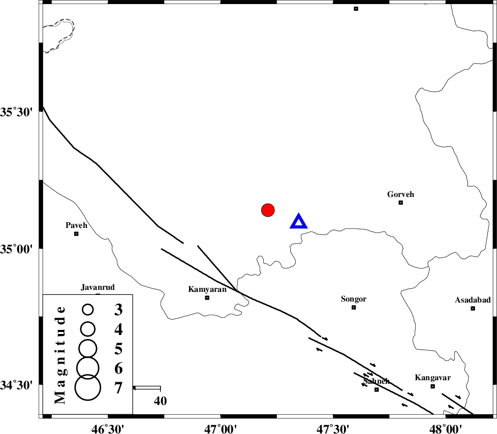
| Location | Lat:35.14 Lon: 47.21 |
| Region | Kurdistan Province, 28 km South-East of Sanandaj |
Nearest Cities |
|
| 6 km North of Muchesh, Kurdistan Province | |
| 21 km West of Laleh, Kurdistan Province | |
| 22 km South of Salavatabad, Kurdistan Province | |
| 23 km South East of Gorizeh, Kurdistan Province | |
| 23 km North East of Ali Abad, Kurdistan Province | |
| Depth | 14 km |
| Agency | |
Faults within 150 km: |
|
| MORVARID_F (Length: 24 km) , Distance to epicenter: 32 km | |
| SARTAKHT_F (Length: 78 km) , Distance to epicenter: 36 km | |
| PIRANSHAHR_F (Length: 253 km) , Distance to epicenter: 37 km | |
| Number of Phases | 6 |
| RMS | 0.1 |
| Number of Stations | 4 |
| Error in Latitude | >2.2 km |
| Error in Longitude | 7.1 km |
| Error in Depth | 6.1 km |
Download waveform in seisan format
to download seisan software Click here
to access information about IIEES stations Click here
Amplitude | ||||||||
| UID | Agency | Station | Component | Amplitude | Period | Arrival Time | Proccessing Time | Signal Clip |
| 86753 | IIEES | KHMZ | E | 230.1 | 0.52 | 2012-10-28 02:22:40 | 2012-10-28 02:52:00 | n |
Phase | ||||||||||||
| Agency | Station | Component | Phase Type | Phase Quality | First Motion | Observed Arrival Time | Time Residual | Loc. Flag | Input Weight | Distance | Azimuth | |
| IIEES | ZNJK | Z | Pg | E | 2012-10-28 02:21:43 | -0.22 | y | 216 | 38 | |||
| IIEES | ZNJK | N | Sg | E | 2012-10-28 02:22:09 | 0.1 | y | 216 | 38 | |||
| IIEES | ASAO | Z | Pn | E | 2012-10-28 02:21:48 | 0.01 | y | 266 | 103 | |||
| IIEES | KHMZ | Z | Pn | E | 2012-10-28 02:21:52 | 0.05 | y | 297 | 121 | |||
| IIEES | KHMZ | N | Sg | E | 2012-10-28 02:22:31 | -0.09 | y | 297 | 121 | |||
| IIEES | GHVR | Z | Pn | E | 2012-10-28 02:22:02 | 0.16 | y | 376 | 100 | |||