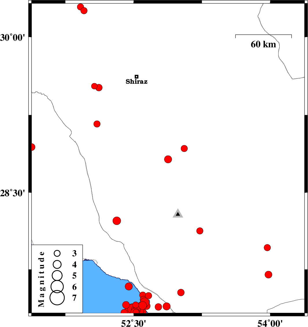
| Prel. Rep. | Date | Time(UTC) | Time(Local) | Lat. | Lon. | Depth | Mag. | Region | Waveform |
|
|
2026/02/18
|
14:08:41.5
|
17:38:41.5
| 28.822 | 52.878 | 14 |
ML:3.7
|
Fars Province, 28 km -East of Firuz Abad | |
|
|
2026/02/17
|
21:20:52.0
|
00:50:52.0
| 27.962 | 53.969 | 12 |
ML:3.3
|
Fars Province, 48 km North-West of Lar | |
|
|
2026/02/17
|
09:05:46.9
|
12:35:46.9
| 27.698 | 53.982 | 12 |
ML:3.5
|
Fars Province, 35 km -West of Lar | |
|
|
2026/02/17
|
08:07:07.0
|
11:37:07.0
| 27.402 | 52.416 | 12 |
ML:3.5
|
Persian Gulf, 49 km South of Jam | |
|
|
2026/02/16
|
13:32:09.3
|
17:02:09.3
| 27.395 | 52.598 | 12 |
ML:3.9
|
Bushehr Province, 33 km South-West of Mehr | |
|
|
2026/02/15
|
14:07:15.7
|
17:37:15.7
| 27.492 | 52.664 | 12 |
ML:3.3
|
Bushehr Province, 23 km -West of Mehr | |
|
|
2026/02/15
|
03:31:18.4
|
07:01:18.4
| 28.926 | 53.056 | 12 |
ML:3.3
|
Fars Province, 51 km North of Qir va Karzin | |
|
|
2026/02/13
|
23:34:45.1
|
03:04:45.1
| 27.401 | 52.522 | 12 |
ML:3.1
|
Persian Gulf, 40 km South-West of Mehr | |
|
|
2026/02/13
|
20:43:14.2
|
00:13:14.2
| 27.33 | 52.525 | 12 |
ML:3
|
Persian Gulf, 43 km South-West of Mehr | |
|
|
2026/02/13
|
19:50:17.1
|
23:20:17.1
| 27.328 | 52.517 | 12 |
ML:4.4
|
Persian Gulf, 44 km South-West of Mehr | |
|
|
2026/02/13
|
19:44:33.2
|
23:14:33.2
| 27.428 | 52.623 | 12 |
ML:4.4
|
, 29 km South-West of Mehr | |
|
|
2026/02/13
|
19:30:19.0
|
23:00:19.0
| 27.36 | 52.532 | 12 |
ML:3.4
|
Persian Gulf, 41 km South-West of Mehr | |
|
|
2026/02/13
|
18:29:29.1
|
21:59:29.1
| 27.355 | 52.51 | 12 |
ML:3.3
|
Persian Gulf, 43 km South-West of Mehr | |
|
|
2026/02/13
|
17:34:26.4
|
21:04:26.4
| 27.454 | 52.608 | 12 |
ML:3.4
|
Persian Gulf, 29 km -West of Mehr | |
|
|
2026/02/13
|
16:35:48.7
|
20:05:48.7
| 27.402 | 52.615 | 12 |
ML:3.3
|
, 31 km South-West of Mehr | |
|
|
2026/02/13
|
16:24:37.2
|
19:54:37.2
| 27.346 | 52.523 | 12 |
ML:3.6
|
Persian Gulf, 42 km South-West of Mehr | |
|
|
2026/02/13
|
11:53:42.2
|
15:23:42.2
| 27.583 | 52.446 | 12 |
ML:3.6
|
Persian Gulf, 31 km South-East of Jam | |
|
|
2026/02/13
|
11:08:36.6
|
14:38:36.6
| 27.363 | 52.486 | 12 |
ML:4.8
|
Persian Gulf, 45 km South-West of Mehr | |
|
|
2026/02/13
|
10:45:16.9
|
14:15:16.9
| 27.358 | 52.534 | 12 |
ML:3.9
|
Persian Gulf, 41 km South-West of Mehr | |
|
|
2026/02/13
|
10:33:19.0
|
14:03:19.0
| 27.371 | 52.484 | 12 |
ML:4.3
|
Persian Gulf, 44 km South-West of Mehr | |
|
|
2026/02/13
|
07:48:58.1
|
11:18:58.1
| 27.401 | 52.581 | 12 |
ML:3.1
|
Persian Gulf, 34 km South-West of Mehr | |
|
|
2026/02/13
|
00:57:48.4
|
04:27:48.4
| 27.335 | 52.516 | 12 |
ML:3.2
|
Persian Gulf, 44 km South-West of Mehr | |
|
|
2026/02/08
|
13:38:02.6
|
17:08:02.6
| 27.326 | 52.395 | 12 |
ML:3.3
|
Persian Gulf, 57 km South of Jam | |
|
|
2026/02/08
|
12:48:58.3
|
16:18:58.3
| 27.498 | 52.6 | 12 |
ML:3.3
|
Bushehr Province, 29 km -West of Mehr | |
|
|
2026/02/08
|
12:43:50.5
|
16:13:50.5
| 28.126 | 53.228 | 10 |
ML:3.3
|
Fars Province, 42 km South-East of Qir va Karzin | |
|
|
2026/02/08
|
12:40:17.6
|
16:10:17.6
| 27.355 | 52.447 | 12 |
ML:3.9
|
Persian Gulf, 55 km South-East of Jam | |
|
|
2026/02/08
|
06:03:42.5
|
09:33:42.5
| 27.523 | 53.02 | 12 |
ML:3.4
|
Fars Province, 13 km -East of Mehr | |
|
|
2026/02/04
|
17:17:50.0
|
20:47:50.0
| 27.342 | 52.557 | 16 |
ML:4.8
|
Persian Gulf, 40 km South-West of Mehr | |
|
|
2026/02/04
|
14:52:38.2
|
18:22:38.2
| 27.328 | 52.597 | 12 |
ML:3.8
|
Persian Gulf, 38 km South-West of Mehr | |
|
|
2026/02/04
|
06:22:39.3
|
09:52:39.3
| 27.387 | 52.862 | 12 |
ML:3.6
|
Bushehr Province, 18 km South of Mehr | |
|
|
2026/02/02
|
21:43:36.2
|
01:13:36.2
| 27.357 | 52.567 | 12 |
ML:3.9
|
Persian Gulf, 38 km South-West of Mehr | |
|
|
2026/02/02
|
12:32:34.1
|
16:02:34.1
| 29.528 | 52.069 | 12 |
ML:3
|
Fars Province, 41 km -East of Kazerun | |
|
|
2026/02/02
|
05:21:58.6
|
08:51:58.6
| 30.251 | 51.955 | 12 |
ML:3.2
|
Fars Province, 3 km of Ardakan | |
|
|
2026/02/01
|
16:29:31.0
|
19:59:31.0
| 27.381 | 52.772 | 12 |
ML:3.4
|
Bushehr Province, 22 km South-West of Mehr | |
|
|
2026/02/01
|
05:28:03.0
|
08:58:03.0
| 27.392 | 52.641 | 12 |
ML:3.6
|
Bushehr Province, 30 km South-West of Mehr | |
|
|
2026/01/31
|
08:30:03.2
|
12:00:03.2
| 30.287 | 51.916 | 12 |
ML:3.2
|
Fars Province, 7 km of Ardakan | |
|
|
2026/01/31
|
08:00:57.9
|
11:30:57.9
| 29.514 | 52.117 | 12 |
ML:3.4
|
Fars Province, 42 km South-West of Shiraz | |
|
|
2026/01/27
|
13:09:33.0
|
16:39:33.0
| 28.941 | 51.378 | 12 |
ML:3.5
|
Bushehr Province, 13 km -East of Ahram | |
|
|
2026/01/26
|
15:12:47.0
|
18:42:47.0
| 29.163 | 52.097 | 10 |
ML:3.3
|
Fars Province, 32 km North of Farashband | |
|
|
2026/01/20
|
03:46:00.9
|
07:16:00.9
| 28.224 | 52.314 | 12 |
ML:3.9
|
Fars Province, 43 km North of Jam | |