
Magnitude |
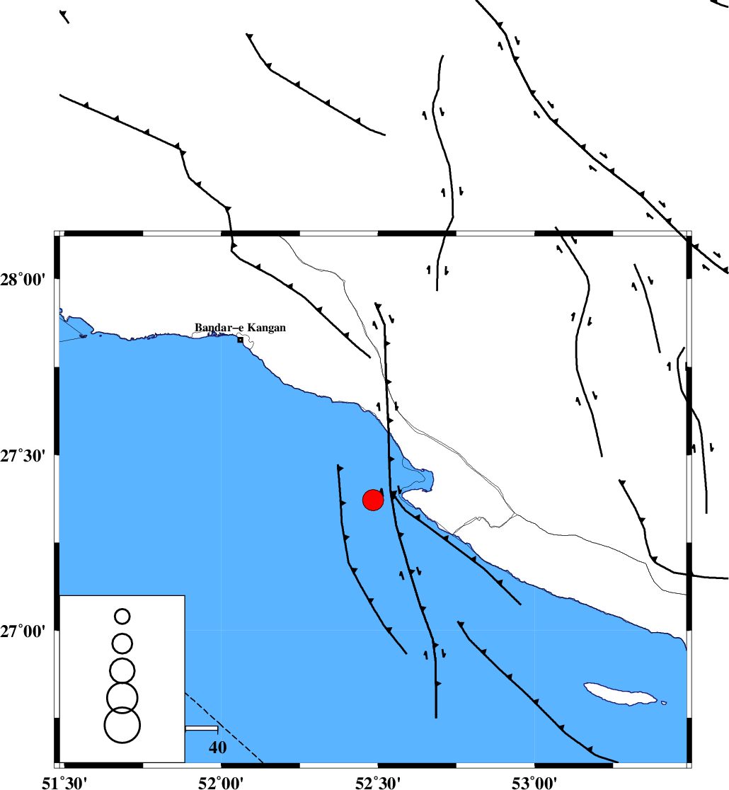
:4.3 |
| Date & Time (UTC) | 2026-02-13 10:33:19.0 |
| Date & Time (Local) | 1404/11/24 14:03:19.0 |
| Location | Lat:27.371 Lon: 52.484 |
| Region | Persian Gulf, 44 km South-West of Mehr |
Nearest Cities |
|
| 17 km South West of Bandar-e asaluyeh, Bushehr Province | |
| 30 km North West of Chah-e mobarak, Bushehr Province | |
| 36 km South East of Bandar-e taheri, Bushehr Province | |
| 37 km South West of Gallehdar, Fars Province | |
| 40 km South West of Ardavan-e olia, Fars Province | |
| Depth | 12 km |
| Agency | |
Faults within 150 km: |
|
| MFF3 (Length: 292 km) , Distance to epicenter: 26 km | |
| BORAZJAN_F (Length: 168 km) , Distance to epicenter: 112 km | |
| MFF5 (Length: 74 km) , Distance to epicenter: 123 km | |
| Number of Phases | 9 |
| RMS | 0.2 |
| Number of Stations | 9 |
| Error in Latitude | >2.4 km |
| Error in Longitude | 2.4 km |
| Error in Depth | 319.8 km |
Download waveform in seisan format
to download seisan software Click here
to access information about IIEES stations Click here
Amplitude | ||||||||
| UID | Agency | Station | Component | Amplitude | Period | Arrival Time | Proccessing Time | Signal Clip |
| 201624 | IIEES SC | UOSS | Z | 0.6 | 1 | 2026-02-13 10:34:23 | 2026-02-22 07:00:00 | n |
| 201625 | IIEES SC | AMS1 | Z | 0.3 | 1 | 2026-02-13 10:34:41 | 2026-02-22 07:00:00 | n |
| 201626 | IIEES SC | KRVR | Z | 0.1 | 1 | 2026-02-13 10:34:46 | 2026-02-22 07:00:00 | n |
| 201627 | IIEES SC | SFB | Z | 0.06 | 1 | 2026-02-13 10:35:02 | 2026-02-22 07:00:00 | n |
Phase | ||||||||||||
| Agency | Station | Component | Phase Type | Phase Quality | First Motion | Observed Arrival Time | Time Residual | Loc. Flag | Input Weight | Distance | Azimuth | |
| IIEES SC | GENO | Z | EPn | E | 2026-02-13 10:34:12 | 0 | y | 0 | 365 | 90 | ||
| IIEES SC | ABH1 | Z | EPn | E | 2026-02-13 10:34:19 | 0.2 | y | 0 | 419 | 329 | ||
| IIEES SC | UOSS | Z | EPn | E | 2026-02-13 10:34:23 | -0.1 | y | 0 | 459 | 126 | ||
| IIEES SC | BRJ | Z | EPn | E | 2026-02-13 10:34:30 | -0.5 | y | 0 | 517 | 347 | ||
| IIEES SC | AMS1 | Z | EPn | E | 2026-02-13 10:34:41 | 0.3 | y | 0 | 599 | 330 | ||
| IIEES SC | KRVR | Z | EPn | E | 2026-02-13 10:34:46 | 0.3 | y | 0 | 636 | 42 | ||
| IIEES SC | SFB | Z | EPn | E | 2026-02-13 10:35:02 | -1 | y | 0 | 774 | 358 | ||
| IIEES SC | HNVD | Z | EPn | E | 2026-02-13 10:35:15 | 0.2 | y | 0 | 870 | 332 | ||
| IIEES SC | SRVN | Z | EPn | E | 2026-02-13 10:35:13 | -15.4 | n | 4 | 981 | 90 | ||