
Magnitude |
:3.3 |
| Date & Time (UTC) | 2026-02-15 14:07:15.7 |
| Date & Time (Local) | 1404/11/26 17:37:15.7 |
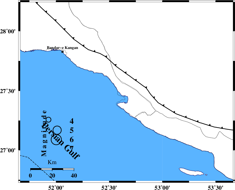
| Location | Lat:27.492 Lon: 52.664 |
| Region | Bushehr Province, 23 km -West of Mehr |
Nearest Cities |
|
| 6 km North of Bandar-e asaluyeh, Bushehr Province | |
| 18 km West of Ardavan-e olia, Fars Province | |
| 18 km South of Gallehdar, Fars Province | |
| 19 km North West of Chah-e mobarak, Bushehr Province | |
| 23 km West of Mehr, Fars Province | |
| Depth | 12 km |
| Agency | |
Faults within 150 km: |
|
| MFF3 (Length: 292 km) , Distance to epicenter: 14 km | |
| QIR_F (Length: 130 km) , Distance to epicenter: 105 km | |
| LAR_F (Length: 99 km) , Distance to epicenter: 121 km | |
| Number of Phases | 6 |
| RMS | 0.4 |
| Number of Stations | 6 |
| Error in Latitude | >5.2 km |
| Error in Longitude | 5.2 km |
| Error in Depth | 660.7 km |
Download waveform in seisan format
to download seisan software Click here
to access information about IIEES stations Click here
Amplitude | ||||||||
| UID | Agency | Station | Component | Amplitude | Period | Arrival Time | Proccessing Time | Signal Clip |
| 201546 | IIEES SC | GENO | Z | 0.1 | 1 | 2026-02-15 14:08:06 | 2026-02-21 09:45:00 | n |
| 201547 | IIEES SC | KRVR | Z | 0.02 | 1 | 2026-02-15 14:08:40 | 2026-02-21 09:45:00 | n |
| 201548 | IIEES SC | IRSR | Z | 0.007 | 1 | 2026-02-15 14:09:05 | 2026-02-21 09:45:00 | n |
Phase | ||||||||||||
| Agency | Station | Component | Phase Type | Phase Quality | First Motion | Observed Arrival Time | Time Residual | Loc. Flag | Input Weight | Distance | Azimuth | |
| IIEES SC | GENO | Z | EPn | E | 2026-02-15 14:08:06 | -0.1 | y | 0 | 347 | 92 | ||
| IIEES SC | UOSS | Z | EPn | E | 2026-02-15 14:08:19 | -0.2 | y | 0 | 452 | 129 | ||
| IIEES SC | AMS1 | Z | EPn | E | 2026-02-15 14:08:38 | 0.4 | y | 0 | 597 | 328 | ||
| IIEES SC | KRVR | Z | EPn | E | 2026-02-15 14:08:40 | 0.1 | y | 0 | 615 | 41 | ||
| IIEES SC | IRSR | Z | EPn | E | 2026-02-15 14:09:05 | 0.5 | y | 0 | 814 | 94 | ||
| IIEES SC | HNVD | Z | EPn | E | 2026-02-15 14:09:10 | -0.9 | y | 0 | 866 | 331 | ||