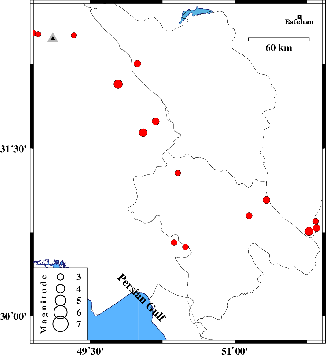
| Prel. Rep. | Date | Time(UTC) | Time(Local) | Lat. | Lon. | Depth | Mag. | Region | Waveform |
|
|
2012/05/15
|
04:11:44.8
|
08:41:44.8
| 31.28 | 50.41 | 14 |
ML:2.7
|
Kohkiluieh va boyerahmad Province, 45 km South-West of Lordegan | |
|
|
2012/05/14
|
18:05:25.7
|
22:35:25.7
| 30.79 | 51.85 | 14 |
ML:3.4
|
Esfahan Province, 30 km North-East of Yasuj | |
|
|
2012/05/14
|
17:18:46.9
|
21:48:46.9
| 30.85 | 51.84 | 14 |
ML:2.8
|
Fars Province, 37 km East of Sisakht | |
|
|
2012/05/14
|
17:12:48.6
|
21:42:48.6
| 30.76 | 51.77 | 15 |
ML:3.9
|
Esfahan Province, 21 km East of Yasuj | |
|
|
2012/05/12
|
06:11:16.4
|
10:41:16.4
| 31.74 | 50.18 | 34 |
ML:3.4
|
Khoozestan Province, 31 km East of Izeh | |
|
|
2012/05/10
|
03:31:27.1
|
08:01:27.1
| 32.25 | 49.99 | 18 |
ML:3.3
|
Chaharmahal Bakhtiari Province, 27 km South-West of Chelgard | |
|
|
2012/05/08
|
08:52:42.0
|
13:22:42.0
| 30.66 | 50.37 | 15 |
ML:2.8
|
Khoozestan Province, 14 km East of Behbahan | |
|
|
2012/05/07
|
21:48:01.0
|
02:18:01.0
| 30.62 | 50.49 | 14 |
ML:2.8
|
Khoozestan Province, 20 km South of Dehdasht | |
|
|
2012/05/07
|
12:54:21.4
|
17:24:21.4
| 31.64 | 50.05 | 15 |
ML:3.8
|
Khoozestan Province, 20 km North-East of Bagh Malek | |
|
|
2012/05/05
|
01:17:43.4
|
05:47:43.4
| 30.9 | 51.15 | 14 |
ML:2.9
|
Kohkiluieh va boyerahmad Province, 30 km West of Sisakht | |
|
|
2012/05/04
|
08:34:28.3
|
13:04:28.3
| 31.04 | 51.33 | 14 |
ML:3.2
|
Kohkiluieh va boyerahmad Province, 22 km North-West of Sisakht | |
|
|
2012/04/30
|
10:37:28.8
|
15:07:28.8
| 32.07 | 49.79 | 14 |
ML:4.1
|
Khoozestan Province, 27 km North of Izeh | |
|
|
2012/04/23
|
03:12:47.9
|
07:42:47.9
| 32.51 | 48.96 | 41 |
ML:2.6
|
Khoozestan Province, 19 km North-West of Lali | |
|
|
2012/04/23
|
03:02:55.4
|
07:32:55.4
| 32.52 | 48.91 | 41 |
ML:2.8
|
Khoozestan Province, 24 km North-West of Lali | |
|
|
2012/04/22
|
03:41:34.6
|
08:11:34.6
| 32.5 | 49.33 | 15 |
ML:2.5
|
Khoozestan Province, 24 km North-East of Lali | |
