
Magnitude |
:3.3 |
| Date & Time (UTC) | 2012-05-10 03:31:27.1 |
| Date & Time (Local) | 1391/2/21 08:01:27.1 |
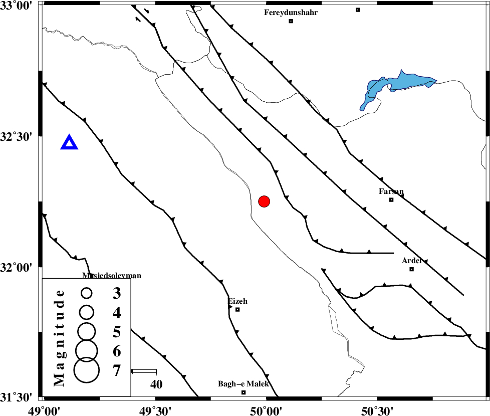
| Location | Lat:32.25 Lon: 49.99 |
| Region | Chaharmahal Bakhtiari Province, 27 km South-West of Chelgard |
Nearest Cities |
|
| 27 km South West of Chelgard, Chaharmahal Bakhtiari Province | |
| 32 km North East of Torshak, Khoozestan Province | |
| 41 km East of Paabshalal, Khoozestan Province | |
| 44 km South West of Kukanak, Esfahan Province | |
| 46 km North East of Rasvand, Khoozestan Province | |
| Depth | 18 km |
| Agency | |
Faults within 150 km: |
|
| ZARDKUH_F (Length: 139 km) , Distance to epicenter: 9 km | |
| ARDAL_F (Length: 170 km) , Distance to epicenter: 29 km | |
| DOPOLAN_F (Length: 107 km) , Distance to epicenter: 37 km | |
| Number of Phases | 5 |
| RMS | 0.1 |
| Number of Stations | 5 |
| Error in Latitude | >1.9 km |
| Error in Longitude | 2.9 km |
| Error in Depth | 4.4 km |
Download waveform in seisan format
to download seisan software Click here
to access information about IIEES stations Click here
Amplitude | ||||||||
| UID | Agency | Station | Component | Amplitude | Period | Arrival Time | Proccessing Time | Signal Clip |
| 83440 | IIEES | SHGR | E | 775.4 | 0.6 | 2012-05-10 03:32:10 | 2012-05-10 04:17:00 | n |
| 83441 | IIEES | SHGR | N | 628 | 0.56 | 2012-05-10 03:32:13 | 2012-05-10 04:17:00 | n |
| 83442 | IIEES | GHVR | E | 254.5 | 0.52 | 2012-05-10 03:32:48 | 2012-05-10 04:17:00 | n |
| 83443 | IIEES | GHVR | N | 213.9 | 0.64 | 2012-05-10 03:32:48 | 2012-05-10 04:17:00 | n |
| 83444 | IIEES | SNGE | E | 40 | 0.56 | 2012-05-10 03:33:36 | 2012-05-10 04:17:00 | n |
Phase | ||||||||||||
| Agency | Station | Component | Phase Type | Phase Quality | First Motion | Observed Arrival Time | Time Residual | Loc. Flag | Input Weight | Distance | Azimuth | |
| IIEES | SHGR | Z | Pg | E | 2012-05-10 03:31:46 | 0.04 | y | 113 | 262 | |||
| IIEES | ASAO | Z | Pn | E | 2012-05-10 03:32:06 | 0.13 | y | 255 | 1 | |||
| IIEES | ASAO | E | Sg | E | 2012-05-10 03:32:39 | -0.01 | y | 255 | 1 | |||
| IIEES | NASN | Z | Pn | E | 2012-05-10 03:32:08 | -0.03 | y | 272 | 76 | |||
| IIEES | SNGE | Z | Pn | E | 2012-05-10 03:32:24 | -0.17 | y | 399 | 323 | |||