
Magnitude |
:2.9 |
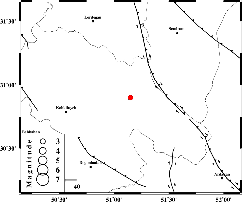
| Date & Time (UTC) | 2012-05-05 01:17:43.4 |
| Date & Time (Local) | 1391/2/16 05:47:43.4 |
| Location | Lat:30.9 Lon: 51.15 |
| Region | Kohkiluieh va boyerahmad Province, 30 km West of Sisakht |
Nearest Cities |
|
| 12 km of Margun, Kohkiluieh va boyerahmad Province | |
| 19 km North West of Chitab, Kohkiluieh va boyerahmad Province | |
| 21 km South of Dezhak, Kohkiluieh va boyerahmad Province | |
| 27 km North West of Kerik, Kohkiluieh va boyerahmad Province | |
| 29 km South West of Meymand, Kohkiluieh va boyerahmad Province | |
| Depth | 14 km |
| Agency | |
Faults within 150 km: |
|
| DENA_F (Length: 137 km) , Distance to epicenter: 26 km | |
| HZF3 (Length: 197 km) , Distance to epicenter: 55 km | |
| MISHAN_F (Length: 76 km) , Distance to epicenter: 57 km | |
| Number of Phases | 7 |
| RMS | 0.1 |
| Number of Stations | 5 |
| Error in Latitude | >3.3 km |
| Error in Longitude | 5.4 km |
| Error in Depth | 7 km |
Download waveform in seisan format
to download seisan software Click here
to access information about IIEES stations Click here
Amplitude | ||||||||
| UID | Agency | Station | Component | Amplitude | Period | Arrival Time | Proccessing Time | Signal Clip |
| 83305 | IIEES | SHGR | E | 94.4 | 0.48 | 2012-05-05 01:19:15 | 2012-05-05 01:56:00 | n |
| 83306 | IIEES | SHGR | N | 102.8 | 0.56 | 2012-05-05 01:19:23 | 2012-05-05 01:56:00 | n |
| 83307 | IIEES | KHMZ | E | 21.3 | 0.64 | 2012-05-05 01:19:37 | 2012-05-05 01:56:00 | n |
| 83308 | IIEES | GHIR | E | 44 | 0.64 | 2012-05-05 01:19:36 | 2012-05-05 01:56:00 | n |
| 83309 | IIEES | GHIR | N | 32.8 | 0.44 | 2012-05-05 01:19:42 | 2012-05-05 01:56:00 | n |
Phase | ||||||||||||
| Agency | Station | Component | Phase Type | Phase Quality | First Motion | Observed Arrival Time | Time Residual | Loc. Flag | Input Weight | Distance | Azimuth | |
| IIEES | SHGR | E | Pn | E | 2012-05-05 01:18:23 | 0.04 | y | 260 | 302 | |||
| IIEES | SHGR | E | Sg | E | 2012-05-05 01:18:56 | -0.08 | y | 260 | 302 | |||
| IIEES | KHMZ | Z | Pn | E | 2012-05-05 01:18:32 | 0.04 | y | 334 | 341 | |||
| IIEES | GHIR | N | Pn | E | 2012-05-05 01:18:33 | -0.08 | y | 340 | 148 | |||
| IIEES | ASAO | Z | Pn | E | 2012-05-05 01:18:43 | -0.01 | y | 418 | 346 | |||
| IIEES | ASAO | E | Sn | 2012-05-05 01:19:26 | -0.13 | y | 418 | 346 | ||||
| IIEES | SNGE | N | Pn | E | 2012-05-05 01:19:04 | 0.32 | y | 585 | 324 | |||