| Prel. Rep. | Date | Time(UTC) | Time(Local) | Lat. | Lon. | Depth | Mag. | Region | Waveform |
|
|
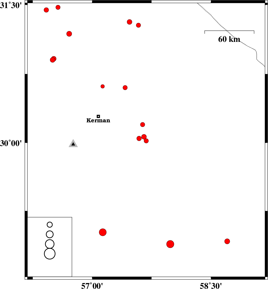
2015/11/15
|
01:27:03.2
|
04:57:03.2
| 30.02 | 57.683 | 14 |
ML:2.5
|
Kerman Province, 65 km South-East of Kerman | |
|
|
2015/11/15
|
01:22:53.6
|
04:52:53.6
| 30.064 | 57.655 | 15 |
ML:2.8
|
Kerman Province, 61 km South-East of Kerman | |
|
|
2015/11/12
|
08:24:42.0
|
11:54:42.0
| 30.615 | 57.132 | 18 |
ML:2.1
|
Kerman Province, 37 km North of Kerman | |
|
|
2015/11/08
|
17:21:02.1
|
20:51:02.1
| 31.473 | 56.569 | 18 |
ML:2.5
|
Kerman Province, 33 km North-West of Ravar | |
|
|
2015/11/07
|
17:12:22.5
|
20:42:22.5
| 30.046 | 57.592 | 6 |
ML:2.7
|
Kerman Province, 56 km South-East of Kerman | |
|
|
2015/11/05
|
16:00:58.5
|
19:30:58.5
| 31.279 | 57.585 | 14 |
ML:2.5
|
Kerman Province, 73 km -East of Ravar | |
|
|
2015/11/04
|
10:04:23.9
|
13:34:23.9
| 31.186 | 56.71 | 18 |
ML:3
|
Kerman Province, 13 km -West of Ravar | |
|
|
2015/11/03
|
23:20:31.5
|
02:50:31.5
| 30.601 | 57.417 | 14 |
ML:2.6
|
Kerman Province, 48 km North-East of Kerman | |
|
|
2015/11/02
|
00:27:59.3
|
03:57:59.3
| 30.903 | 56.501 | 14 |
ML:2.8
|
Kerman Province, 12 km of Zarand | |
|
|
2015/10/31
|
20:52:16.7
|
00:22:16.7
| 30.916 | 56.514 | 14 |
ML:2.8
|
Kerman Province, 13 km North of Zarand | |
|
|
2015/10/31
|
17:12:59.8
|
20:42:59.8
| 28.913 | 58.706 | 14 |
ML:3
|
Kerman Province, 40 km South-East of Bam | |
|
|
2015/10/22
|
21:09:38.7
|
00:39:38.7
| 29.014 | 57.134 | 14 |
ML:4.1
|
Kerman Province, 57 km South-East of Baft | |
|
|
2015/10/18
|
18:22:07.3
|
21:52:07.3
| 31.444 | 56.421 | 14 |
ML:2.7
|
Kerman Province, 42 km North-West of Ravar | |
|
|
2015/10/18
|
06:45:54.2
|
10:15:54.2
| 28.882 | 57.987 | 14 |
ML:4.2
|
Kerman Province, 34 km North-East of Jiroft | |
|
|
2015/10/18
|
05:42:09.9
|
09:12:09.9
| 31.314 | 57.472 | 14 |
ML:2.8
|
Kerman Province, 63 km -East of Ravar | |
|
|
2015/10/16
|
09:28:03.6
|
12:58:03.6
| 30.198 | 57.637 | 15 |
ML:2.6
|
Kerman Province, 55 km -East of Kerman | |
|
|
2015/10/16
|
06:06:51.6
|
09:36:51.6
| 28.593 | 56.294 | 15 |
ML:2.5
|
Kerman Province, 50 km North-East of Hajiabad | |
|
|
2015/10/16
|
04:14:20.9
|
07:44:20.9
| 28.588 | 56.349 | 14 |
ML:2.7
|
Kerman Province, 54 km North-East of Hajiabad | |
