
Magnitude |
:3 |
| Date & Time (UTC) | 2015-11-04 10:04:23.9 |
| Date & Time (Local) | 1394/8/13 13:34:23.9 |
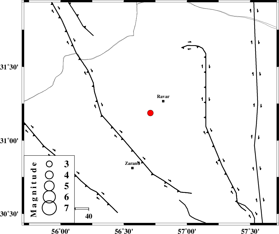
| Location | Lat:31.186 Lon: 56.71 |
| Region | Kerman Province, 13 km -West of Ravar |
Nearest Cities |
|
| 13 km West of Ravar, Kerman Province | |
| 17 km South of Dehali, Kerman Province | |
| 20 km North East of Dasht-e khak, Kerman Province | |
| 21 km North of Ahmadi, Kerman Province | |
| 28 km North East of Toghroljerd, Kerman Province | |
| Depth | 18 km |
| Agency | |
Faults within 150 km: |
|
| KUHBANAN_F (Length: 189 km) , Distance to epicenter: 29 km | |
| LAKARKUH_F (Length: 138 km) , Distance to epicenter: 43 km | |
| CHATRUD_F (Length: 37 km) , Distance to epicenter: 69 km | |
| Number of Phases | 6 |
| RMS | 0.2 |
| Number of Stations | 5 |
| Error in Latitude | >2.5 km |
| Error in Longitude | 2.5 km |
| Error in Depth | 5.2 km |
Download waveform in seisan format
to download seisan software Click here
to access information about IIEES stations Click here
Amplitude | ||||||||
| UID | Agency | Station | Component | Amplitude | Period | Arrival Time | Proccessing Time | Signal Clip |
| 102231 | IIEES | YZKH | N | 110.1 | 0.37 | 2015-11-04 10:05:31 | 2015-11-07 02:12:00 | n |
| 102232 | IIEES | YZKH | E | 102.7 | 0.49 | 2015-11-04 10:05:34 | 2015-11-07 02:12:00 | n |
| 102233 | IIEES | TABS | N | 73 | 0.59 | 2015-11-04 10:05:52 | 2015-11-07 02:12:00 | n |
Phase | ||||||||||||
| Agency | Station | Component | Phase Type | Phase Quality | First Motion | Observed Arrival Time | Time Residual | Loc. Flag | Input Weight | Distance | Azimuth | |
| IIEES | KRBR | Z | Pg | E | 2015-11-04 10:04:46 | 0.16 | y | 134 | 178 | |||
| IIEES | YZKH | Z | Pn | E | 2015-11-04 10:05:01 | -0.14 | y | 241 | 304 | |||
| IIEES | BSRN | Z | Pn | E | 2015-11-04 10:05:01 | -0.05 | y | 245 | 69 | |||
| IIEES | BSRN | N | Sg | E | 2015-11-04 10:05:33 | 0.04 | y | 245 | 69 | |||
| IIEES | TABS | Z | Pn | E | 2015-11-04 10:05:05 | 0.19 | y | 276 | 8 | |||
| IIEES | ZHSF | Z | Pn | E | 2015-11-04 10:05:24 | -0.27 | y | 428 | 113 | |||