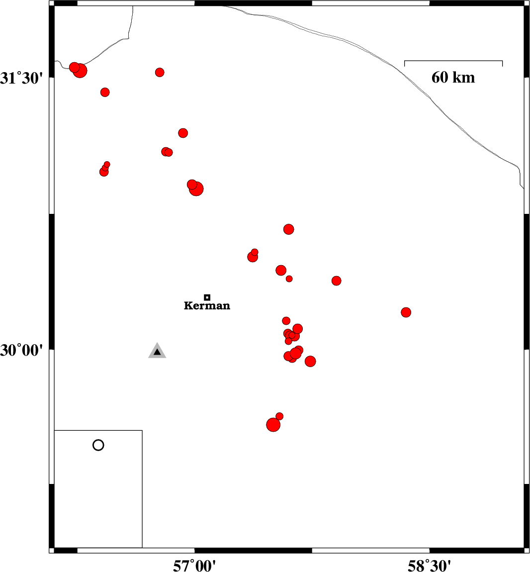
| Prel. Rep. | Date | Time(UTC) | Time(Local) | Lat. | Lon. | Depth | Mag. | Region | Waveform |
|
|
2015/09/24
|
10:11:06.2
|
13:41:06.2
| 30.391 | 57.603 | 14 |
ML:1.8
|
Kerman Province, 52 km North-East of Kerman | |
|
|
2015/09/22
|
00:33:13.1
|
04:03:13.1
| 29.977 | 57.645 | 18 |
ML:3.2
|
Kerman Province, 64 km South-East of Kerman | |
|
|
2015/09/20
|
01:52:47.4
|
06:22:47.4
| 30.158 | 57.584 | 14 |
ML:2.2
|
Kerman Province, 51 km South-East of Kerman | |
|
|
2015/09/19
|
21:45:27.4
|
02:15:27.4
| 29.627 | 57.542 | 14 |
ML:2.1
|
Kerman Province, 86 km South-East of Kerman | |
|
|
2015/09/19
|
20:42:06.1
|
01:12:06.1
| 31.554 | 56.232 | 18 |
ML:2.9
|
Yazd Province, 64 km North-West of Ravar | |
|
|
2015/09/18
|
21:00:05.4
|
01:30:05.4
| 31.527 | 56.776 | 14 |
ML:2.6
|
Kerman Province, 29 km North of Ravar | |
|
|
2015/09/18
|
12:30:12.3
|
17:00:12.3
| 31.022 | 56.44 | 14 |
ML:1.7
|
Kerman Province, 26 km North-West of Zarand | |
|
|
2015/09/18
|
02:06:09.7
|
06:36:09.7
| 29.58 | 57.502 | 14 |
ML:4
|
Kerman Province, 89 km South-East of Kerman | |
|
|
2015/09/16
|
22:03:54.1
|
02:33:54.1
| 30.539 | 57.383 | 14 |
ML:2
|
Kerman Province, 40 km North-East of Kerman | |
|
|
2015/09/13
|
12:44:59.2
|
17:14:59.2
| 31.003 | 56.428 | 18 |
ML:1.9
|
Kerman Province, 25 km North-West of Zarand | |
|
|
2015/09/11
|
15:39:39.6
|
20:09:39.6
| 30.114 | 57.657 | 14 |
ML:2.8
|
Kerman Province, 59 km South-East of Kerman | |
|
|
2015/09/11
|
00:55:47.6
|
05:25:47.6
| 30.078 | 57.62 | 14 |
ML:1.8
|
Kerman Province, 57 km South-East of Kerman | |
|
|
2015/09/10
|
07:35:06.8
|
12:05:06.8
| 29.996 | 57.663 | 18 |
ML:2.6
|
Kerman Province, 65 km South-East of Kerman | |
|
|
2015/09/10
|
04:56:13.5
|
09:26:13.5
| 30.046 | 57.599 | 18 |
ML:2
|
Kerman Province, 57 km South-East of Kerman | |
|
|
2015/09/06
|
02:36:39.0
|
07:06:39.0
| 31.088 | 56.833 | 14 |
ML:2.2
|
Kerman Province, 20 km South of Ravar | |
|
|
2015/09/06
|
01:35:42.5
|
06:05:42.5
| 31.092 | 56.816 | 14 |
ML:2.5
|
Kerman Province, 19 km South of Ravar | |
|
|
2015/09/05
|
09:20:54.4
|
13:50:54.4
| 30.982 | 56.42 | 17 |
ML:2.6
|
Kerman Province, 24 km North-West of Zarand | |
|
|
2015/09/04
|
15:32:31.5
|
20:02:31.5
| 29.963 | 57.598 | 15 |
ML:2.7
|
Kerman Province, 62 km South-East of Kerman | |
|
|
2015/09/03
|
07:22:40.1
|
11:52:40.1
| 30.381 | 57.905 | 14 |
ML:2.7
|
Kerman Province, 80 km -East of Kerman | |
|
|
2015/09/01
|
17:19:38.2
|
21:49:38.2
| 30.205 | 58.35 | 18 |
ML:2.8
|
Kerman Province, 122 km North of Bam | |
|
|
2015/09/01
|
12:54:29.4
|
17:24:29.4
| 30.665 | 57.6 | 18 |
ML:3
|
Kerman Province, 65 km North-East of Kerman | |
|
|
2015/08/31
|
14:45:12.2
|
19:15:12.2
| 31.195 | 56.925 | 14 |
ML:2.7
|
Kerman Province, 13 km -East of Ravar | |
|
|
2015/08/31
|
09:24:50.9
|
13:54:50.9
| 30.438 | 57.551 | 15 |
ML:2.9
|
Kerman Province, 48 km North-East of Kerman | |
|
|
2015/08/31
|
09:21:24.1
|
13:51:24.1
| 29.951 | 57.622 | 18 |
ML:2.6
|
Kerman Province, 64 km South-East of Kerman | |
|
|
2015/08/31
|
02:18:15.1
|
06:48:15.1
| 29.933 | 57.738 | 14 |
ML:3.1
|
Kerman Province, 75 km South-East of Kerman | |
|
|
2015/08/29
|
07:45:02.0
|
12:15:02.0
| 31.418 | 56.427 | 14 |
ML:2.6
|
Kerman Province, 40 km North-West of Ravar | |
|
|
2015/08/28
|
11:22:23.8
|
15:52:23.8
| 30.512 | 57.37 | 14 |
ML:2.9
|
Kerman Province, 37 km North-East of Kerman | |
|
|
2015/08/27
|
09:26:55.8
|
13:56:55.8
| 30.912 | 56.983 | 18 |
ML:2.8
|
Kerman Province, 41 km North-East of Zarand | |
|
|
2015/08/26
|
21:46:29.7
|
02:16:29.7
| 30.075 | 57.637 | 14 |
ML:3
|
Kerman Province, 59 km South-East of Kerman | |
|
|
2015/08/26
|
13:20:26.6
|
17:50:26.6
| 30.888 | 57.01 | 15 |
ML:4.1
|
Kerman Province, 43 km -East of Zarand | |
|
|
2015/08/25
|
21:26:21.7
|
01:56:21.7
| 30.075 | 57.611 | 14 |
ML:2.9
|
Kerman Province, 56 km South-East of Kerman | |
|
|
2015/08/25
|
06:17:10.8
|
10:47:10.8
| 31.537 | 56.267 | 14 |
ML:4.1
|
Kerman Province, 60 km North-West of Ravar | |
|
|
2015/08/25
|
02:27:41.6
|
06:57:41.6
| 30.088 | 57.595 | 14 |
ML:2.6
|
Kerman Province, 54 km South-East of Kerman | |