
Magnitude |
:2.8 |
| Date & Time (UTC) | 2015-08-27 09:26:55.8 |
| Date & Time (Local) | 1394/6/5 13:56:55.8 |
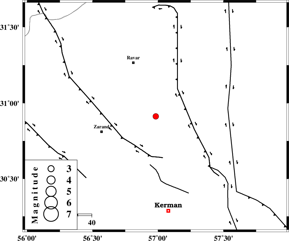
| Location | Lat:30.912 Lon: 56.983 |
| Region | Kerman Province, 41 km North-East of Zarand |
Nearest Cities |
|
| 17 km North of Hejdak, Kerman Province | |
| 20 km North East of Hatkan, Kerman Province | |
| 28 km North East of Khankuk, Kerman Province | |
| 32 km North West of Harjand, Kerman Province | |
| 35 km North of Chatrud, Kerman Province | |
| Depth | 18 km |
| Agency | |
Faults within 150 km: |
|
| LAKARKUH_F (Length: 138 km) , Distance to epicenter: 26 km | |
| KUHBANAN_F (Length: 189 km) , Distance to epicenter: 26 km | |
| CHATRUD_F (Length: 37 km) , Distance to epicenter: 36 km | |
| Number of Phases | 5 |
| RMS | 0.2 |
| Number of Stations | 4 |
| Error in Latitude | >3.8 km |
| Error in Longitude | 5 km |
| Error in Depth | 9.5 km |
Download waveform in seisan format
to download seisan software Click here
to access information about IIEES stations Click here
Amplitude | ||||||||
| UID | Agency | Station | Component | Amplitude | Period | Arrival Time | Proccessing Time | Signal Clip |
| 100551 | IIEES | BSRN | E | 91.4 | 0.33 | 2015-08-27 09:28:07 | 2015-08-29 09:10:00 | n |
| 100552 | IIEES | TABS | E | 28.1 | 0.28 | 2015-08-27 09:28:29 | 2015-08-29 09:10:00 | n |
Phase | ||||||||||||
| Agency | Station | Component | Phase Type | Phase Quality | First Motion | Observed Arrival Time | Time Residual | Loc. Flag | Input Weight | Distance | Azimuth | |
| IIEES | KRBR | Z | Pg | E | 2015-08-27 09:27:13 | 0.09 | y | 105 | 192 | |||
| IIEES | BSRN | Z | Pn | E | 2015-08-27 09:27:32 | -0.18 | y | 235 | 60 | |||
| IIEES | YZKH | Z | Pn | E | 2015-08-27 09:27:37 | -0.27 | y | 280 | 306 | |||
| IIEES | YZKH | E | Sg | E | 2015-08-27 09:28:14 | 0.02 | y | 280 | 306 | |||
| IIEES | TABS | Z | P | E | 2015-08-27 09:27:41 | 0.36 | y | 304 | 2 | |||