| Prel. Rep. | Date | Time(UTC) | Time(Local) | Lat. | Lon. | Depth | Mag. | Region | Waveform |
|
|
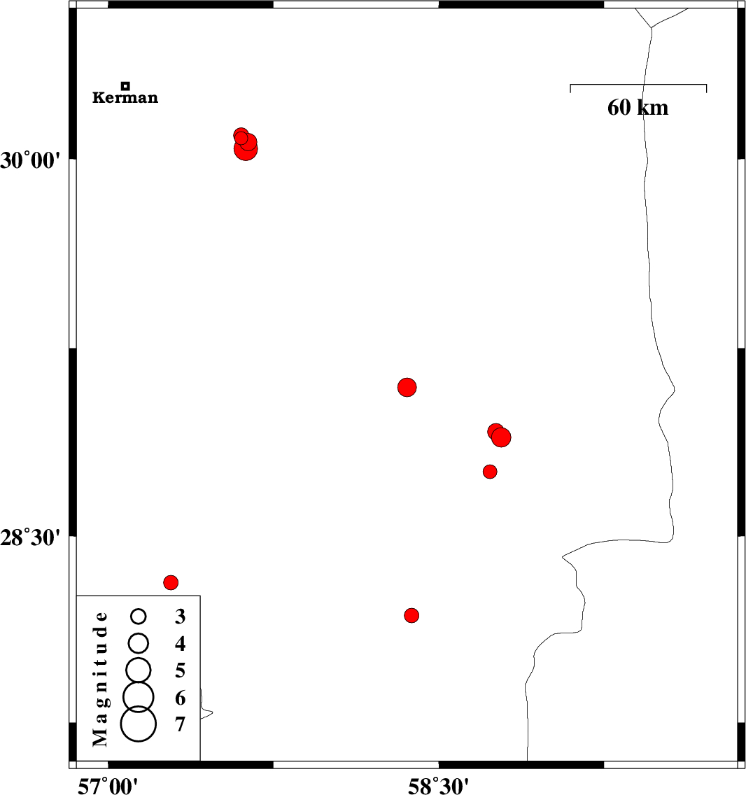
2015/07/29
|
11:00:12.5
|
15:30:12.5
| 29.094 | 58.356 | 18 |
ML:3.8
|
Kerman Province, 2 km of Bam | |
|
|
2015/07/29
|
05:11:59.0
|
09:41:59.0
| 28.313 | 57.285 | 6 |
ML:2.9
|
Kerman Province, 57 km North-West of Kahnuj | |
|
|
2015/07/28
|
16:53:07.8
|
21:23:07.8
| 30.082 | 57.603 | 18 |
ML:2.7
|
Kerman Province, 55 km South-East of Kerman | |
|
|
2015/07/26
|
22:40:34.6
|
03:10:34.6
| 28.181 | 58.377 | 14 |
ML:3
|
Kerman Province, 72 km North-East of Kahnuj | |
|
|
2015/07/25
|
17:28:11.2
|
21:58:11.2
| 30.066 | 57.636 | 15 |
ML:3.5
|
Kerman Province, 59 km South-East of Kerman | |
|
|
2015/07/25
|
16:32:18.8
|
21:02:18.8
| 30.093 | 57.604 | 14 |
ML:3.1
|
Kerman Province, 55 km South-East of Kerman | |
|
|
2015/07/25
|
16:10:41.6
|
20:40:41.6
| 30.041 | 57.624 | 18 |
ML:4.8
|
Kerman Province, 59 km South-East of Kerman | |
|
|
2015/07/24
|
15:04:18.3
|
19:34:18.3
| 28.894 | 58.784 | 14 |
ML:3.9
|
Kerman Province, 48 km South-East of Bam | |
|
|
2015/07/24
|
02:51:57.0
|
07:21:57.0
| 28.757 | 58.732 | 14 |
ML:2.8
|
Kerman Province, 54 km South-East of Bam | |
|
|
2015/07/22
|
07:49:33.4
|
12:19:33.4
| 28.917 | 58.76 | 14 |
ML:3.4
|
Kerman Province, 45 km South-East of Bam | |
