
Magnitude |
:3.9 |
| Date & Time (UTC) | 2015-07-24 15:04:18.3 |
| Date & Time (Local) | 1394/5/2 19:34:18.3 |
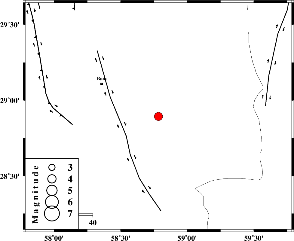
| Location | Lat:28.894 Lon: 58.784 |
| Region | Kerman Province, 48 km South-East of Bam |
Nearest Cities |
|
| 11 km North West of Void, Kerman Province | |
| 12 km West of Fahroj, Kerman Province | |
| 16 km East of Qasemabad, Kerman Province | |
| 21 km East of Abshur-e nezamabad, Kerman Province | |
| 22 km North of Mohammadabad-e gonbaki, Kerman Province | |
| Depth | 14 km |
| Agency | |
Faults within 150 km: |
|
| BAM_F (Length: 118 km) , Distance to epicenter: 28 km | |
| GOWK_F (Length: 152 km) , Distance to epicenter: 63 km | |
| KANURAK_F (Length: 135 km) , Distance to epicenter: 79 km | |
| Number of Phases | 5 |
| RMS | 0.2 |
| Number of Stations | 3 |
| Error in Latitude | >6.6 km |
| Error in Longitude | 2 km |
| Error in Depth | 9.6 km |
Download waveform in seisan format
to download seisan software Click here
to access information about IIEES stations Click here
Amplitude | ||||||||
| UID | Agency | Station | Component | Amplitude | Period | Arrival Time | Proccessing Time | Signal Clip |
| 100178 | IIEES | KRBR | N | 661.1 | 0.2 | 2015-07-24 15:05:25 | 2015-07-26 07:34:00 | n |
| 100179 | IIEES | KRBR | E | 954.2 | 0.24 | 2015-07-24 15:05:25 | 2015-07-26 07:34:00 | n |
Phase | ||||||||||||
| Agency | Station | Component | Phase Type | Phase Quality | First Motion | Observed Arrival Time | Time Residual | Loc. Flag | Input Weight | Distance | Azimuth | |
| IIEES | ZHSF | Z | Pn | E | 2015-07-24 15:04:52 | 0.18 | y | 209 | 67 | |||
| IIEES | ZHSF | N | Sg | E | 2015-07-24 15:05:17 | -0.18 | y | 209 | 67 | |||
| IIEES | KRBR | Z | Pn | E | 2015-07-24 15:04:55 | 0.39 | y | 230 | 302 | |||
| IIEES | KRBR | N | Sg | E | 2015-07-24 15:05:23 | -0.2 | y | 230 | 302 | |||
| IIEES | BNDS | Z | Pn | E | 2015-07-24 15:05:03 | -0.21 | y | 305 | 238 | |||