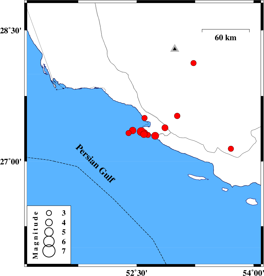
| Prel. Rep. | Date | Time(UTC) | Time(Local) | Lat. | Lon. | Depth | Mag. | Region | Waveform |
|
|
2026/02/11
|
23:56:23.9
|
03:26:23.9
| 27.311 | 52.592 | 12 |
ML:3.9
|
Persian Gulf, 39 km South-West of Mehr | |
|
|
2026/02/11
|
01:56:15.8
|
05:26:15.8
| 27.304 | 52.643 | 12 |
ML:3.2
|
Persian Gulf, 36 km South-West of Mehr | |
|
|
2026/02/08
|
13:38:02.6
|
17:08:02.6
| 27.326 | 52.395 | 12 |
ML:3.3
|
Persian Gulf, 57 km South of Jam | |
|
|
2026/02/08
|
12:48:58.3
|
16:18:58.3
| 27.498 | 52.6 | 12 |
ML:3.3
|
Bushehr Province, 29 km -West of Mehr | |
|
|
2026/02/08
|
12:43:50.5
|
16:13:50.5
| 28.126 | 53.228 | 10 |
ML:3.3
|
Fars Province, 42 km South-East of Qir va Karzin | |
|
|
2026/02/08
|
12:40:17.6
|
16:10:17.6
| 27.355 | 52.447 | 12 |
ML:3.9
|
Persian Gulf, 55 km South-East of Jam | |
|
|
2026/02/08
|
06:03:42.5
|
09:33:42.5
| 27.523 | 53.02 | 12 |
ML:3.4
|
Fars Province, 13 km -East of Mehr | |
|
|
2026/02/06
|
17:54:51.6
|
21:24:51.6
| 27.145 | 53.708 | 12 |
ML:3.2
|
Fars Province, 65 km -West of Bastak | |
|
|
2026/02/04
|
17:17:50.0
|
20:47:50.0
| 27.342 | 52.557 | 16 |
ML:4.8
|
Persian Gulf, 40 km South-West of Mehr | |
|
|
2026/02/04
|
14:52:38.2
|
18:22:38.2
| 27.328 | 52.597 | 12 |
ML:3.8
|
Persian Gulf, 38 km South-West of Mehr | |
|
|
2026/02/04
|
13:31:28.4
|
17:01:28.4
| 27.295 | 52.736 | 12 |
ML:4.2
|
Bushehr Province, 32 km South-West of Mehr | |
|
|
2026/02/04
|
06:22:39.3
|
09:52:39.3
| 27.387 | 52.862 | 12 |
ML:3.6
|
Bushehr Province, 18 km South of Mehr | |
