| Prel. Rep. | Date | Time(UTC) | Time(Local) | Lat. | Lon. | Depth | Mag. | Region | Waveform |
|
|
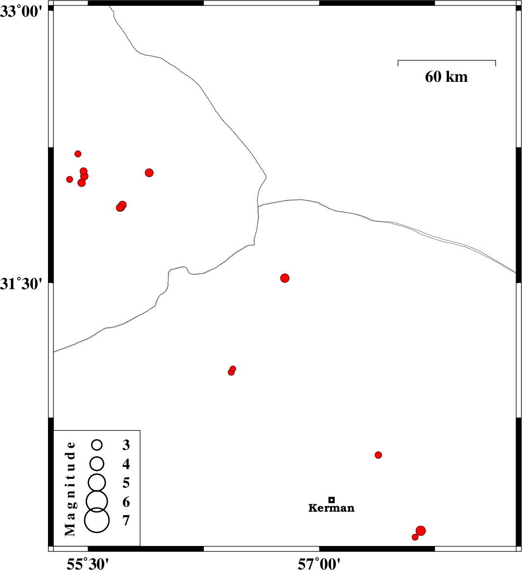
2015/09/18
|
21:00:05.4
|
01:30:05.4
| 31.527 | 56.776 | 14 |
ML:2.6
|
Kerman Province, 29 km North of Ravar | |
|
|
2015/09/18
|
12:30:12.3
|
17:00:12.3
| 31.022 | 56.44 | 14 |
ML:1.7
|
Kerman Province, 26 km North-West of Zarand | |
|
|
2015/09/18
|
09:00:43.1
|
13:30:43.1
| 32.213 | 55.435 | 18 |
ML:1.9
|
Yazd Province, 68 km North of Bafq | |
|
|
2015/09/17
|
09:04:26.1
|
13:34:26.1
| 32.073 | 55.381 | 14 |
ML:1.9
|
Yazd Province, 52 km North of Bafq | |
|
|
2015/09/17
|
09:02:57.1
|
13:32:57.1
| 32.118 | 55.472 | 15 |
ML:2.1
|
Yazd Province, 58 km North of Bafq | |
|
|
2015/09/17
|
08:10:23.3
|
12:40:23.3
| 31.916 | 55.707 | 14 |
ML:2.1
|
Yazd Province, 45 km North-East of Bafq | |
|
|
2015/09/16
|
22:03:54.1
|
02:33:54.1
| 30.539 | 57.383 | 14 |
ML:2
|
Kerman Province, 40 km North-East of Kerman | |
|
|
2015/09/15
|
09:22:52.2
|
13:52:52.2
| 31.932 | 55.724 | 17 |
ML:2.2
|
Yazd Province, 48 km North-East of Bafq | |
|
|
2015/09/15
|
00:03:59.9
|
04:33:59.9
| 32.11 | 55.896 | 15 |
ML:2.4
|
Yazd Province, 73 km North-East of Bafq | |
|
|
2015/09/13
|
12:44:59.2
|
17:14:59.2
| 31.003 | 56.428 | 18 |
ML:1.9
|
Kerman Province, 25 km North-West of Zarand | |
|
|
2015/09/13
|
09:42:59.7
|
14:12:59.7
| 32.091 | 55.476 | 14 |
ML:2.3
|
Yazd Province, 55 km North of Bafq | |
|
|
2015/09/13
|
08:07:19.4
|
12:37:19.4
| 31.919 | 55.713 | 14 |
ML:2.3
|
Yazd Province, 46 km North-East of Bafq | |
|
|
2015/09/11
|
15:39:39.6
|
20:09:39.6
| 30.114 | 57.657 | 14 |
ML:2.8
|
Kerman Province, 59 km South-East of Kerman | |
|
|
2015/09/11
|
08:56:44.8
|
13:26:44.8
| 32.054 | 55.459 | 18 |
ML:2.2
|
Yazd Province, 50 km North of Bafq | |
|
|
2015/09/11
|
00:55:47.6
|
05:25:47.6
| 30.078 | 57.62 | 14 |
ML:1.8
|
Kerman Province, 57 km South-East of Kerman | |
