| Prel. Rep. | Date | Time(UTC) | Time(Local) | Lat. | Lon. | Depth | Mag. | Region | Waveform |
|
|
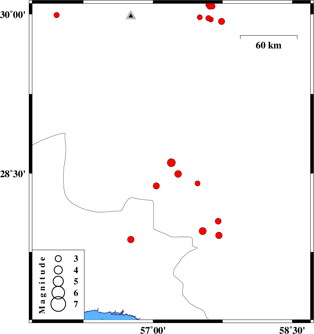
2015/09/08
|
01:18:28.8
|
05:48:28.8
| 28.601 | 57.197 | 14 |
ML:4
|
Kerman Province, 53 km -West of Jiroft | |
|
|
2015/09/04
|
15:32:31.5
|
20:02:31.5
| 29.963 | 57.598 | 15 |
ML:2.7
|
Kerman Province, 62 km South-East of Kerman | |
|
|
2015/09/04
|
04:28:26.6
|
08:58:26.6
| 27.87 | 56.76 | 14 |
ML:3.2
|
Hormozgan Province, 68 km North-West of Dehbarez | |
|
|
2015/08/31
|
09:21:24.1
|
13:51:24.1
| 29.951 | 57.622 | 18 |
ML:2.6
|
Kerman Province, 64 km South-East of Kerman | |
|
|
2015/08/31
|
02:18:15.1
|
06:48:15.1
| 29.933 | 57.738 | 14 |
ML:3.1
|
Kerman Province, 75 km South-East of Kerman | |
|
|
2015/08/30
|
00:23:57.3
|
04:53:57.3
| 28.044 | 57.702 | 14 |
ML:2.9
|
Kerman Province, 10 km of Kahnuj | |
|
|
2015/08/26
|
21:46:29.7
|
02:16:29.7
| 30.075 | 57.637 | 14 |
ML:3
|
Kerman Province, 59 km South-East of Kerman | |
|
|
2015/08/25
|
21:26:21.7
|
01:56:21.7
| 30.075 | 57.611 | 14 |
ML:2.9
|
Kerman Province, 56 km South-East of Kerman | |
|
|
2015/08/25
|
02:27:41.6
|
06:57:41.6
| 30.088 | 57.595 | 14 |
ML:2.6
|
Kerman Province, 54 km South-East of Kerman | |
|
|
2015/08/24
|
19:58:34.3
|
00:28:34.3
| 28.495 | 57.27 | 16 |
ML:3.4
|
Kerman Province, 50 km South-West of Jiroft | |
|
|
2015/08/17
|
10:34:31.0
|
15:04:31.0
| 29.992 | 55.961 | 14 |
ML:2.7
|
Kerman Province, 46 km South of Rafsanjan | |
|
|
2015/08/16
|
16:03:14.0
|
20:33:14.0
| 28.404 | 57.479 | 17 |
ML:2.6
|
Kerman Province, 39 km South-West of Jiroft | |
|
|
2015/08/13
|
00:26:04.6
|
04:56:04.6
| 27.909 | 57.71 | 14 |
ML:3.2
|
Kerman Province, 5 km of Kahnuj | |
|
|
2015/08/12
|
22:10:38.0
|
02:40:38.0
| 27.95 | 57.536 | 14 |
ML:3.5
|
Kerman Province, 16 km -West of Kahnuj | |
|
|
2015/08/11
|
02:59:49.6
|
07:29:49.6
| 28.38 | 57.035 | 16 |
ML:3.1
|
Kerman Province, 76 km South-West of Jiroft | |
|
|
2015/08/09
|
13:45:12.8
|
18:15:12.8
| 29.971 | 57.504 | 30 |
ML:2.6
|
Kerman Province, 54 km South-East of Kerman | |
