
Magnitude |
:2.7 |
| Date & Time (UTC) | 2015-05-06 22:37:56.1 |
| Date & Time (Local) | 1394/2/17 03:07:56.1 |
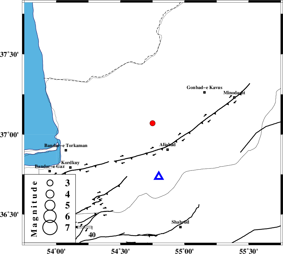
| Location | Lat:37.07 Lon: 54.75 |
| Region | Golestan Province, 21 km North-West of Ali Abad |
Nearest Cities |
|
| 2 km of Gariduji, Golestan Province | |
| 18 km North East of Nodeh malek, Golestan Province | |
| 21 km North West of Ali Abad, Golestan Province | |
| 22 km North West of Khanbebin, Golestan Province | |
| 23 km North East of Qanqarmeh, Golestan Province | |
| Depth | 31 km |
| Agency | |
Faults within 150 km: |
|
| KHAZAR_F (Length: 523 km) , Distance to epicenter: 20 km | |
| SHAVAR_F (Length: 87 km) , Distance to epicenter: 50 km | |
| N_ALBORZ_F (Length: 360 km) , Distance to epicenter: 60 km | |
| Number of Phases | 5 |
| RMS | 0 |
| Number of Stations | 4 |
| Error in Latitude | >2.3 km |
| Error in Longitude | 3.1 km |
| Error in Depth | 3.7 km |
Download waveform in seisan format
to download seisan software Click here
to access information about IIEES stations Click here
Amplitude | ||||||||
| UID | Agency | Station | Component | Amplitude | Period | Arrival Time | Proccessing Time | Signal Clip |
| 95597 | IIEES | MRVT | E | 144.1 | 0.24 | 2015-05-06 22:38:36 | 2015-05-07 03:55:00 | n |
| 95598 | IIEES | MRVT | N | 113.3 | 0.24 | 2015-05-06 22:38:36 | 2015-05-07 03:55:00 | n |
Phase | ||||||||||||
| Agency | Station | Component | Phase Type | Phase Quality | First Motion | Observed Arrival Time | Time Residual | Loc. Flag | Input Weight | Distance | Azimuth | |
| IIEES | MRVT | Z | Pg | E | 2015-05-06 22:38:18 | 0.07 | y | 136 | 60 | |||
| IIEES | MRVT | E | Sg | E | 2015-05-06 22:38:34 | -0.06 | y | 136 | 60 | |||
| IIEES | SHRO | Z | Pg | E | 2015-05-06 22:38:22 | 0 | y | 163 | 136 | |||
| IIEES | BJRD | Z | Pn | E | 2015-05-06 22:38:32 | 0.02 | y | 246 | 73 | |||
| IIEES | DAMV | Z | Pn | E | 2015-05-06 22:38:39 | -0.03 | y | 296 | 238 | |||