
Magnitude |
:2.8 |
| Date & Time (UTC) | 2015-02-25 09:03:33.5 |
| Date & Time (Local) | 1393/12/6 12:33:33.5 |
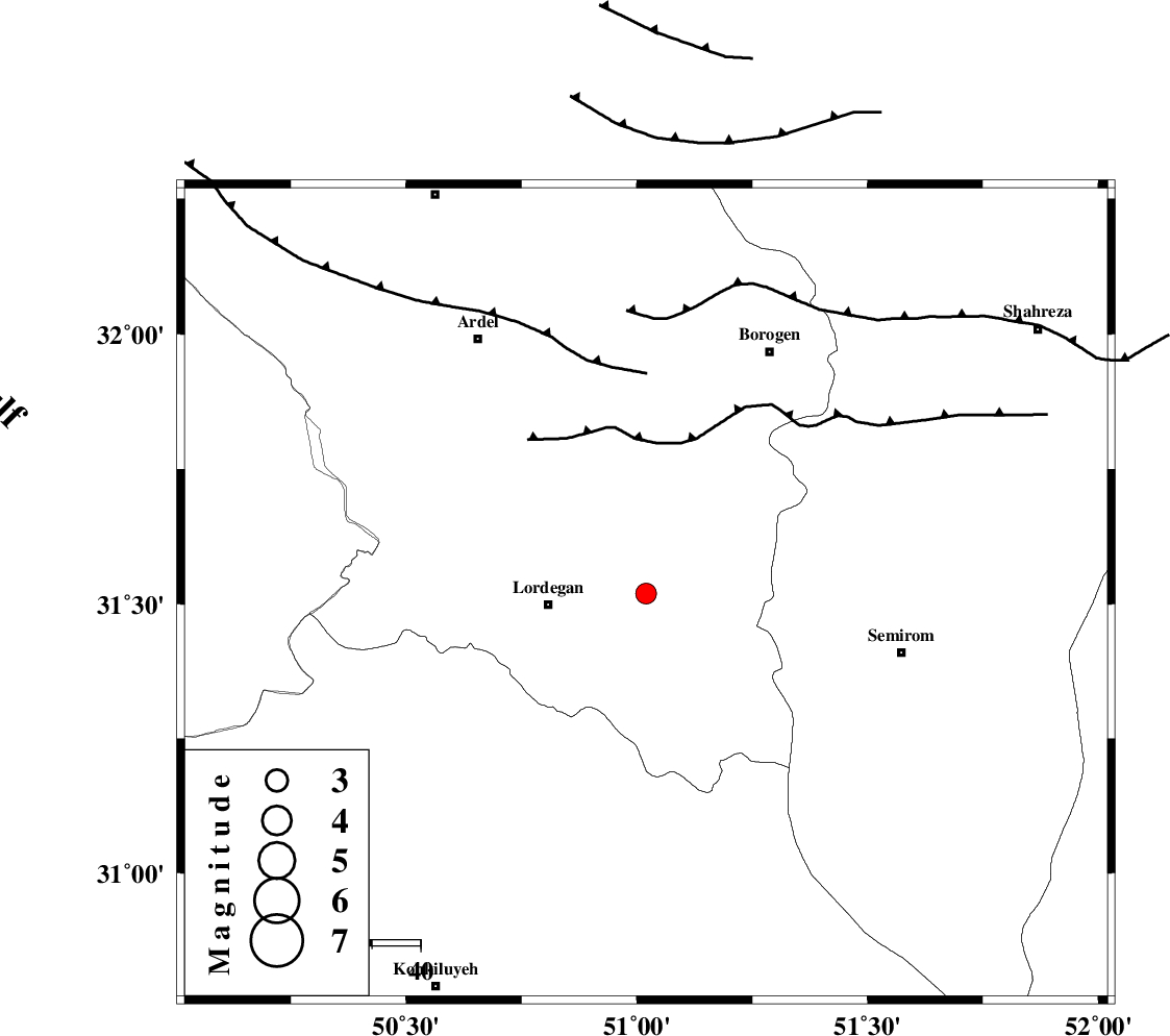
| Location | Lat:31.52 Lon: 51.02 |
| Region | Chaharmahal Bakhtiari Province, 21 km East of Lordegan |
Nearest Cities |
|
| 5 km of Aluni, Chaharmahal Bakhtiari Province | |
| 20 km North East of Lordegan, Chaharmahal Bakhtiari Province | |
| 23 km North East of Sardasht, Chaharmahal Bakhtiari Province | |
| 25 km South East of Armand-e olia, Chaharmahal Bakhtiari Province | |
| 29 km West of Vanak, Esfahan Province | |
| Depth | 14 km |
| Agency | |
Faults within 150 km: |
|
| DOPOLAN_F (Length: 107 km) , Distance to epicenter: 17 km | |
| DENA_F (Length: 137 km) , Distance to epicenter: 19 km | |
| SABZKUH_F (Length: 67 km) , Distance to epicenter: 27 km | |
| Number of Phases | 5 |
| RMS | 0.2 |
| Number of Stations | 4 |
| Error in Latitude | >8.5 km |
| Error in Longitude | 2.4 km |
| Error in Depth | 6.6 km |
Download waveform in seisan format
to download seisan software Click here
to access information about IIEES stations Click here
Amplitude | ||||||||
| UID | Agency | Station | Component | Amplitude | Period | Arrival Time | Proccessing Time | Signal Clip |
| 95098 | IIEES | SHGR | E | 78.8 | 0.74 | 2015-02-25 09:05:05 | 2015-02-25 09:40:00 | n |
Phase | ||||||||||||
| Agency | Station | Component | Phase Type | Phase Quality | First Motion | Observed Arrival Time | Time Residual | Loc. Flag | Input Weight | Distance | Azimuth | |
| IIEES | NASN | Z | Pg | E | 2015-02-25 09:04:09 | -0.08 | y | 220 | 49 | |||
| IIEES | SHGR | Z | Pg | E | 2015-02-25 09:04:09 | -0.33 | y | 220 | 288 | |||
| IIEES | SHGR | N | Sg | E | 2015-02-25 09:04:36 | 0.24 | y | 220 | 288 | |||
| IIEES | GHVR | Z | Pn | E | 2015-02-25 09:04:22 | -0.03 | y | 329 | 4 | |||
| IIEES | YZKH | Z | Pn | E | 2015-02-25 09:04:25 | 0.22 | y | 351 | 73 | |||