
Magnitude |
:3.2 |
| Date & Time (UTC) | 2014-05-10 13:36:37.4 |
| Date & Time (Local) | 1393/2/20 18:06:37.4 |
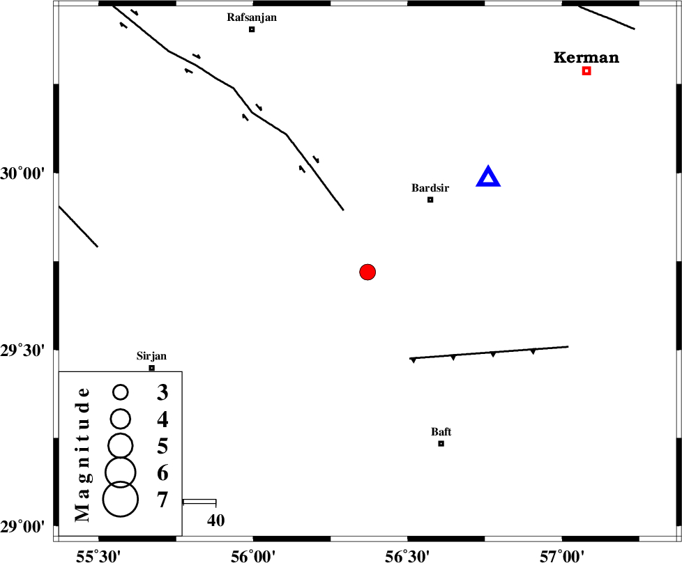
| Location | Lat:29.72 Lon: 56.37 |
| Region | Kerman Province, 30 km South-West of Bardsir |
Nearest Cities |
|
| 8 km of Tekyeh, Kerman Province | |
| 27 km South of Mahutak, Kerman Province | |
| 29 km North of Amirabad, Kerman Province | |
| 30 km South West of Bardsir, Kerman Province | |
| 36 km South West of Dashtkar, Kerman Province | |
| Depth | 14 km |
| Agency | |
Faults within 150 km: |
|
| RAFSANJAN_F (Length: 129 km) , Distance to epicenter: 21 km | |
| LALEHZAR_F (Length: 52 km) , Distance to epicenter: 30 km | |
| SHAHR_E_BABAK_F2 (Length: 272 km) , Distance to epicenter: 85 km | |
| Number of Phases | 7 |
| RMS | 0.5 |
| Number of Stations | 5 |
| Error in Latitude | >5.6 km |
| Error in Longitude | 5.3 km |
| Error in Depth | 12.7 km |
Download waveform in seisan format
to download seisan software Click here
to access information about IIEES stations Click here
Amplitude | ||||||||
| UID | Agency | Station | Component | Amplitude | Period | Arrival Time | Proccessing Time | Signal Clip |
| 92387 | IIEES | BSRN | N | 57.2 | 0.64 | 2014-05-10 13:38:31 | 2014-05-10 02:59:00 | n |
Phase | ||||||||||||
| Agency | Station | Component | Phase Type | Phase Quality | First Motion | Observed Arrival Time | Time Residual | Loc. Flag | Input Weight | Distance | Azimuth | |
| IIEES | KRBR | Z | P | E | 2014-05-10 13:36:45 | -0.9 | y | 47.9 | 52 | |||
| IIEES | KRBR | E | Sg | E | 2014-05-10 13:36:53 | 0.21 | y | 47.9 | 52 | |||
| IIEES | BNDS | Z | Pn | E | 2014-05-10 13:37:17 | -0.1 | y | 258 | 184 | |||
| IIEES | YZKH | Z | Pn | E | 2014-05-10 13:37:27 | 0.1 | y | 341 | 331 | |||
| IIEES | YZKH | N | Sg | E | 2014-05-10 13:38:13 | -0.17 | y | 341 | 331 | |||
| IIEES | BSRN | Z | Pn | E | 2014-05-10 13:37:31 | 0.77 | y | 363 | 46 | |||
| IIEES | TABS | Z | Pn | E | 2014-05-10 13:37:40 | 0.27 | y | 442 | 9 | |||