
Magnitude |
:4.1 |
| Date & Time (UTC) | 2014-04-05 12:16:32.0 |
| Date & Time (Local) | 1393/1/16 16:46:32.0 |
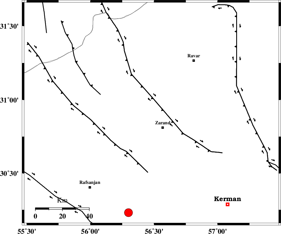
| Location | Lat:30.91 Lon: 56.48 |
| Region | Kerman Province, 14 km Zarand |
Nearest Cities |
|
| 14 km North of Zarand, Kerman Province | |
| 16 km North of Mohammadabad, Kerman Province | |
| 18 km West of Ahmadi, Kerman Province | |
| 18 km South of Dasht-e khak, Kerman Province | |
| 25 km North West of Bahaabad, Kerman Province | |
| Depth | 14 km |
| Agency | |
Faults within 150 km: |
|
| KUHBANAN_F (Length: 189 km) , Distance to epicenter: 11 km | |
| DARIVAN_F (Length: 131 km) , Distance to epicenter: 35 km | |
| CHATRUD_F (Length: 37 km) , Distance to epicenter: 56 km | |
| Number of Phases | 6 |
| RMS | 0.2 |
| Number of Stations | 5 |
| Error in Latitude | >2.9 km |
| Error in Longitude | 4 km |
| Error in Depth | 6.6 km |
Download waveform in seisan format
to download seisan software Click here
to access information about IIEES stations Click here
Amplitude | ||||||||
| UID | Agency | Station | Component | Amplitude | Period | Arrival Time | Proccessing Time | Signal Clip |
| 92161 | IIEES | YZKH | E | 1322.9 | 0.36 | 2014-04-05 12:17:42 | 2014-04-05 01:45:00 | n |
| 92162 | IIEES | TABS | N | 694.2 | 0.6 | 2014-04-05 12:18:07 | 2014-04-05 01:45:00 | n |
Phase | ||||||||||||
| Agency | Station | Component | Phase Type | Phase Quality | First Motion | Observed Arrival Time | Time Residual | Loc. Flag | Input Weight | Distance | Azimuth | |
| IIEES | KRBR | Z | Pg | E | 2014-04-05 12:16:49 | -0.2 | y | 106 | 165 | |||
| IIEES | YZKH | Z | Pn | E | 2014-04-05 12:17:10 | 0.33 | y | 243 | 313 | |||
| IIEES | YZKH | N | Sg | E | 2014-04-05 12:17:40 | -0.31 | y | 243 | 313 | |||
| IIEES | TABS | Z | Pn | E | 2014-04-05 12:17:18 | 0.11 | y | 310 | 11 | |||
| IIEES | SHRT | Z | Pn | E | 2014-04-05 12:17:38 | -0.12 | y | 471 | 49 | |||
| IIEES | AHRM | Z | Pn | E | 2014-04-05 12:17:48 | 0.26 | y | 549 | 247 | |||