
Magnitude |
:2.4 |
| Date & Time (UTC) | 2014-03-14 18:56:49.0 |
| Date & Time (Local) | 1392/12/23 22:26:49.0 |
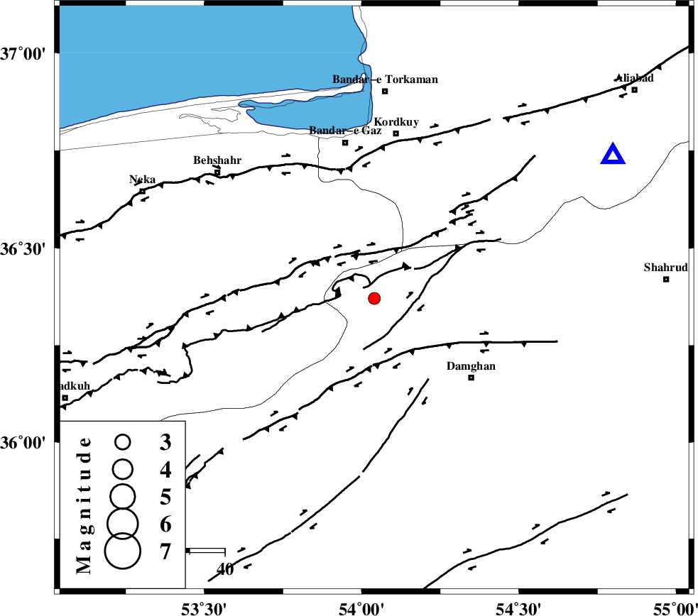
| Location | Lat:36.37 Lon: 54.04 |
| Region | Semnan Province, 48 km South of Kordkuy |
Nearest Cities |
|
| 29 km South East of Bishehboneh, Mazandaran Province | |
| 29 km South East of Sefid chah, Mazandaran Province | |
| 35 km North East of Talma darreh, Mazandaran Province | |
| 36 km North West of Damghan, Semnan Province | |
| 36 km North West of Seydabad, Semnan Province | |
| Depth | 18 km |
| Agency | |
Faults within 150 km: |
|
| ASTANEH_F (Length: 72 km) , Distance to epicenter: 11 km | |
| N_ALBORZ_F (Length: 360 km) , Distance to epicenter: 15 km | |
| DAMGHAN_F (Length: 95 km) , Distance to epicenter: 21 km | |
| Number of Phases | 4 |
| RMS | 0.1 |
| Number of Stations | 4 |
| Error in Latitude | >7.7 km |
| Error in Longitude | 3.1 km |
| Error in Depth | 8.5 km |
Download waveform in seisan format
to download seisan software Click here
to access information about IIEES stations Click here
Amplitude | ||||||||
| UID | Agency | Station | Component | Amplitude | Period | Arrival Time | Proccessing Time | Signal Clip |
| 91999 | IIEES | GHVR | E | 10.9 | 0.53 | 2014-03-14 18:58:28 | 2014-03-15 12:45:00 | n |
Phase | ||||||||||||
| Agency | Station | Component | Phase Type | Phase Quality | First Motion | Observed Arrival Time | Time Residual | Loc. Flag | Input Weight | Distance | Azimuth | |
| IIEES | SHRO | E | Pn | E | 2014-03-14 18:57:19 | 0.03 | y | 182 | 102 | |||
| IIEES | CHTH | N | Pn | E | 2014-03-14 18:57:29 | -0.21 | y | 267 | 260 | |||
| IIEES | CHTH | N | Sg | E | 2014-03-14 18:58:04 | 0.13 | y | 267 | 260 | |||
| IIEES | BJRD | E | Pn | E | 2014-03-14 18:57:37 | 0.05 | y | 334 | 63 | |||