
Magnitude |
:3.1 |
| Date & Time (UTC) | 2013-04-05 20:10:27.2 |
| Date & Time (Local) | 1392/1/17 00:40:27.2 |
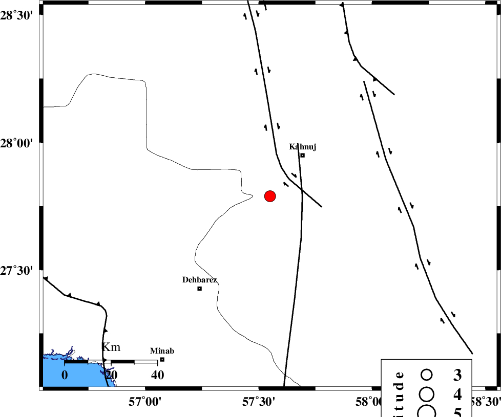
| Location | Lat:27.79 Lon: 57.55 |
| Region | Kerman Province, 23 km South-West of Kahnuj |
Nearest Cities |
|
| 20 km North West of Bargah, Kerman Province | |
| 23 km South West of Kahnuj, Kerman Province | |
| 23 km North of Bejogan, Kerman Province | |
| 27 km East of Fariab, Hormozgan Province | |
| 29 km North East of Nodezh, Kerman Province | |
| Depth | 15 km |
| Agency | |
Faults within 150 km: |
|
| SABZEVARAN_F (Length: 190 km) , Distance to epicenter: 11 km | |
| JIROFT_F (Length: 144 km) , Distance to epicenter: 26 km | |
| ZENDAN_MINAB_F_Z1 (Length: 183 km) , Distance to epicenter: 59 km | |
| Number of Phases | 4 |
| RMS | 0.2 |
| Number of Stations | 4 |
| Error in Latitude | >6.4 km |
| Error in Longitude | 2 km |
| Error in Depth | 0 km |
Download waveform in seisan format
to download seisan software Click here
to access information about IIEES stations Click here
Amplitude | ||||||||
| UID | Agency | Station | Component | Amplitude | Period | Arrival Time | Proccessing Time | Signal Clip |
| 88405 | IIEES | KRBR | E | 84 | 0.44 | 2013-04-05 20:11:42 | 2013-04-05 10:00:00 | n |
| 88406 | IIEES | GHIR | N | 21 | 0.56 | 2013-04-05 20:12:27 | 2013-04-05 10:00:00 | n |
| 88407 | IIEES | GHIR | E | 26.4 | 0.44 | 2013-04-05 20:12:27 | 2013-04-05 10:00:00 | n |
Phase | ||||||||||||
| Agency | Station | Component | Phase Type | Phase Quality | First Motion | Observed Arrival Time | Time Residual | Loc. Flag | Input Weight | Distance | Azimuth | |
| IIEES | KRBR | Z | Pn | E | 2013-04-05 20:11:06 | 0.18 | y | 255 | 343 | |||
| IIEES | ZHSF | Z | Pn | E | 2013-04-05 20:11:21 | 0.11 | y | 374 | 57 | |||
| IIEES | GHIR | Z | Pn | E | 2013-04-05 20:11:30 | -0.06 | y | 452 | 278 | |||
| IIEES | BSRN | Z | Pn | E | 2013-04-05 20:11:35 | -0.33 | y | 488 | 18 | |||