
Magnitude |
:3.6 |
| Date & Time (UTC) | 2012-11-24 10:52:18.5 |
| Date & Time (Local) | 1391/9/4 14:22:18.5 |
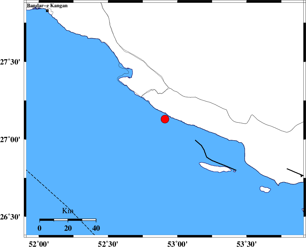
| Location | Lat:27.13 Lon: 52.91 |
| Region | Persian Gulf, 46 km South of Mehr |
Nearest Cities |
|
| 28 km South East of Chah-e mobarak, Bushehr Province | |
| 34 km South West of Lamerd, Fars Province | |
| 36 km South of Khoozi, Fars Province | |
| 46 km South of Mehr, Fars Province | |
| 48 km South East of Bandar-e asaluyeh, Bushehr Province | |
| Depth | 18 km |
| Agency | |
Faults within 150 km: |
|
| MFF3 (Length: 292 km) , Distance to epicenter: 18 km | |
| ZFF1 (Length: 165 km) , Distance to epicenter: 95 km | |
| LAR_F (Length: 99 km) , Distance to epicenter: 112 km | |
| Number of Phases | 5 |
| RMS | 0.1 |
| Number of Stations | 3 |
| Error in Latitude | >4.2 km |
| Error in Longitude | 2.2 km |
| Error in Depth | 5.7 km |
Download waveform in seisan format
to download seisan software Click here
to access information about IIEES stations Click here
Amplitude | ||||||||
| UID | Agency | Station | Component | Amplitude | Period | Arrival Time | Proccessing Time | Signal Clip |
| 87132 | IIEES | GHIR | N | 1628 | 0.6 | 2012-11-24 10:52:58 | 2012-11-24 11:02:00 | n |
| 87133 | IIEES | GHIR | E | 1795.5 | 0.36 | 2012-11-24 10:53:02 | 2012-11-24 11:02:00 | n |
| 87134 | IIEES | AHRM | E | 228.8 | 0.44 | 2012-11-24 10:53:38 | 2012-11-24 11:02:00 | n |
| 87135 | IIEES | AHRM | N | 226.3 | 0.44 | 2012-11-24 10:53:44 | 2012-11-24 11:02:00 | n |
Phase | ||||||||||||
| Agency | Station | Component | Phase Type | Phase Quality | First Motion | Observed Arrival Time | Time Residual | Loc. Flag | Input Weight | Distance | Azimuth | |
| IIEES | GHIR | Z | Pg | E | 2012-11-24 10:52:40 | 0.02 | y | 128 | 4 | |||
| IIEES | GHIR | E | Sg | E | 2012-11-24 10:52:55 | 0.02 | y | 128 | 4 | |||
| IIEES | AHRM | Z | Pn | E | 2012-11-24 10:52:56 | 0.05 | y | 249 | 321 | |||
| IIEES | AHRM | N | Sg | E | 2012-11-24 10:53:28 | -0.03 | y | 249 | 321 | |||
| IIEES | TABS | Z | Pn | E | 2012-11-24 10:54:08 | -0.15 | y | 828 | 28 | |||