
Magnitude |
:2.9 |
| Date & Time (UTC) | 2012-09-23 05:09:39.8 |
| Date & Time (Local) | 1391/7/2 08:39:39.8 |
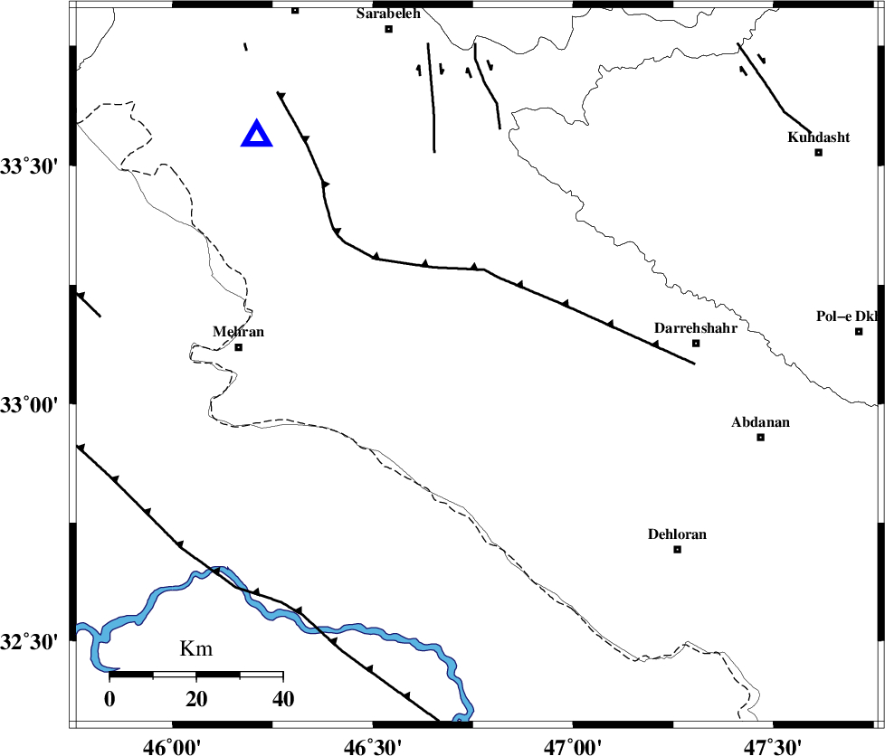
| Location | Lat:33.08 Lon: 46.76 |
| Region | Ilam Province, 51 km West of Darreh Shahr |
Nearest Cities |
|
| 24 km South West of Meymeh, Ilam Province | |
| 27 km South East of Gonbad-e pirmohammad, Ilam Province | |
| 29 km South West of Badreh, Ilam Province | |
| 35 km North West of Bishehzar, Ilam Province | |
| 42 km South East of Galeh-yedarre-hemalakshahi, Ilam Province | |
| Depth | 42 km |
| Agency | |
Faults within 150 km: |
|
| MFF6 (Length: 144 km) , Distance to epicenter: 13 km | |
| MFF7 (Length: 99 km) , Distance to epicenter: 29 km | |
| ZFF4 (Length: 128 km) , Distance to epicenter: 32 km | |
| Number of Phases | 6 |
| RMS | 0.1 |
| Number of Stations | 5 |
| Error in Latitude | >2.7 km |
| Error in Longitude | 8.7 km |
| Error in Depth | 3.3 km |
Download waveform in seisan format
to download seisan software Click here
to access information about IIEES stations Click here
Amplitude | ||||||||
| UID | Agency | Station | Component | Amplitude | Period | Arrival Time | Proccessing Time | Signal Clip |
| 86252 | IIEES | SNGE | N | 87.5 | 0.6 | 2012-09-23 05:10:51 | 2012-09-23 05:35:00 | n |
| 86253 | IIEES | SNGE | E | 131.4 | 0.68 | 2012-09-23 05:10:53 | 2012-09-23 05:35:00 | n |
| 86254 | IIEES | KHMZ | N | 23 | 0.54 | 2012-09-23 05:11:03 | 2012-09-23 05:35:00 | n |
| 86255 | IIEES | ASAO | E | 23.6 | 0.59 | 2012-09-23 05:11:26 | 2012-09-23 05:35:00 | n |
Phase | ||||||||||||
| Agency | Station | Component | Phase Type | Phase Quality | First Motion | Observed Arrival Time | Time Residual | Loc. Flag | Input Weight | Distance | Azimuth | |
| IIEES | SHGR | Z | Pg | E | 2012-09-23 05:10:15 | 0.01 | y | 220 | 119 | |||
| IIEES | SNGE | Z | Pn | E | 2012-09-23 05:10:13 | -0.01 | y | 230 | 14 | |||
| IIEES | SNGE | E | Sg | E | 2012-09-23 05:10:44 | -0.01 | y | 230 | 14 | |||
| IIEES | KHMZ | Z | Pn | E | 2012-09-23 05:10:23 | -0.23 | y | 307 | 75 | |||
| IIEES | ASAO | Z | Pn | E | 2012-09-23 05:10:28 | 0.15 | y | 344 | 61 | |||
| IIEES | GHVR | Z | Pn | E | 2012-09-23 05:10:40 | 0.13 | y | 444 | 68 | |||