
Magnitude |
:2.8 |
| Date & Time (UTC) | 2012-06-27 23:18:26.6 |
| Date & Time (Local) | 1391/4/8 03:48:26.6 |
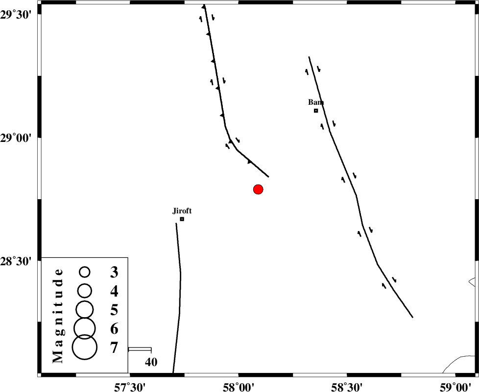
| Location | Lat:28.79 Lon: 58.09 |
| Region | Kerman Province, 36 km North-East of Jiroft |
Nearest Cities |
|
| 17 km North East of Mijan-e sofla, Kerman Province | |
| 20 km East of Saghdar, Kerman Province | |
| 21 km South East of Mohammadabad, Kerman Province | |
| 22 km North of Dahane-ye gomrokan, Kerman Province | |
| 34 km North East of Dolatabad, Kerman Province | |
| Depth | 18 km |
| Agency | |
Faults within 150 km: |
|
| GOWK_F (Length: 152 km) , Distance to epicenter: 7 km | |
| SABZEVARAN_F (Length: 190 km) , Distance to epicenter: 40 km | |
| BAM_F (Length: 118 km) , Distance to epicenter: 41 km | |
| Number of Phases | 5 |
| RMS | 0.2 |
| Number of Stations | 3 |
| Error in Latitude | >1.8 km |
| Error in Longitude | 3.5 km |
| Error in Depth | 6.8 km |
Download waveform in seisan format
to download seisan software Click here
to access information about IIEES stations Click here
Amplitude | ||||||||
| UID | Agency | Station | Component | Amplitude | Period | Arrival Time | Proccessing Time | Signal Clip |
| 84265 | IIEES | KRBR | E | 102.5 | 0.16 | 2012-06-27 23:19:22 | 2012-06-27 11:53:00 | n |
| 84266 | IIEES | KRBR | N | 104.1 | 0.64 | 2012-06-27 23:19:24 | 2012-06-27 11:53:00 | n |
Phase | ||||||||||||
| Agency | Station | Component | Phase Type | Phase Quality | First Motion | Observed Arrival Time | Time Residual | Loc. Flag | Input Weight | Distance | Azimuth | |
| IIEES | KRBR | Z | Pn | E | 2012-06-27 23:18:56 | -0.22 | y | 185 | 316 | |||
| IIEES | KRBR | N | Sg | E | 2012-06-27 23:19:19 | 0.12 | y | 185 | 316 | |||
| IIEES | BNDS | Z | Pn | E | 2012-06-27 23:19:04 | -0.17 | y | 243 | 231 | |||
| IIEES | BNDS | N | Sg | E | 2012-06-27 23:19:35 | 0.14 | y | 243 | 231 | |||
| IIEES | ZHSF | Z | Pn | E | 2012-06-27 23:19:08 | 0.14 | y | 277 | 70 | |||