
Magnitude |
:2.7 |
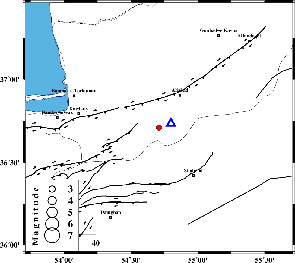
| Date & Time (UTC) | 2012-06-02 14:38:22.3 |
| Date & Time (Local) | 1391/3/13 19:08:22.3 |
| Location | Lat:36.71 Lon: 54.71 |
| Region | Golestan Province, 26 km South-West of Ali Abad |
Nearest Cities |
|
| 21 km South East of Jalin olia, Golestan Province | |
| 25 km North East of Naharkhoran, Golestan Province | |
| 26 km South West of Ali Abad, Golestan Province | |
| 26 km North of Majen, Semnan Province | |
| 28 km South East of Gorgan, Golestan Province | |
| Depth | 14 km |
| Agency | |
Faults within 150 km: |
|
| SHAVAR_F (Length: 87 km) , Distance to epicenter: 17 km | |
| KHAZAR_F (Length: 523 km) , Distance to epicenter: 24 km | |
| ASTANEH_F (Length: 72 km) , Distance to epicenter: 27 km | |
| Number of Phases | 4 |
| RMS | 0 |
| Number of Stations | 4 |
| Error in Latitude | >2.5 km |
| Error in Longitude | 3.1 km |
| Error in Depth | 4.7 km |
Download waveform in seisan format
to download seisan software Click here
to access information about IIEES stations Click here
Amplitude | ||||||||
| UID | Agency | Station | Component | Amplitude | Period | Arrival Time | Proccessing Time | Signal Clip |
| 83860 | IIEES | MRVT | N | 111.5 | 0.16 | 2012-06-02 14:39:14 | 2012-06-02 03:02:00 | n |
| 83861 | IIEES | MRVT | E | 103 | 0.12 | 2012-06-02 14:39:15 | 2012-06-02 03:02:00 | n |
Phase | ||||||||||||
| Agency | Station | Component | Phase Type | Phase Quality | First Motion | Observed Arrival Time | Time Residual | Loc. Flag | Input Weight | Distance | Azimuth | |
| IIEES | SHRO | Z | Pg | E | 2012-06-02 14:38:45 | 0 | y | 140 | 123 | |||
| IIEES | MRVT | Z | Pg | E | 2012-06-02 14:38:49 | -0.05 | y | 162 | 49 | |||
| IIEES | BJRD | Z | Pn | E | 2012-06-02 14:39:02 | 0.07 | y | 264 | 64 | |||
| IIEES | DAMV | Z | Pn | E | 2012-06-02 14:39:04 | -0.02 | y | 274 | 245 | |||