
Magnitude |
:3.1 |
| Date & Time (UTC) | 2012-03-29 06:16:47.2 |
| Date & Time (Local) | 1391/1/10 10:46:47.2 |
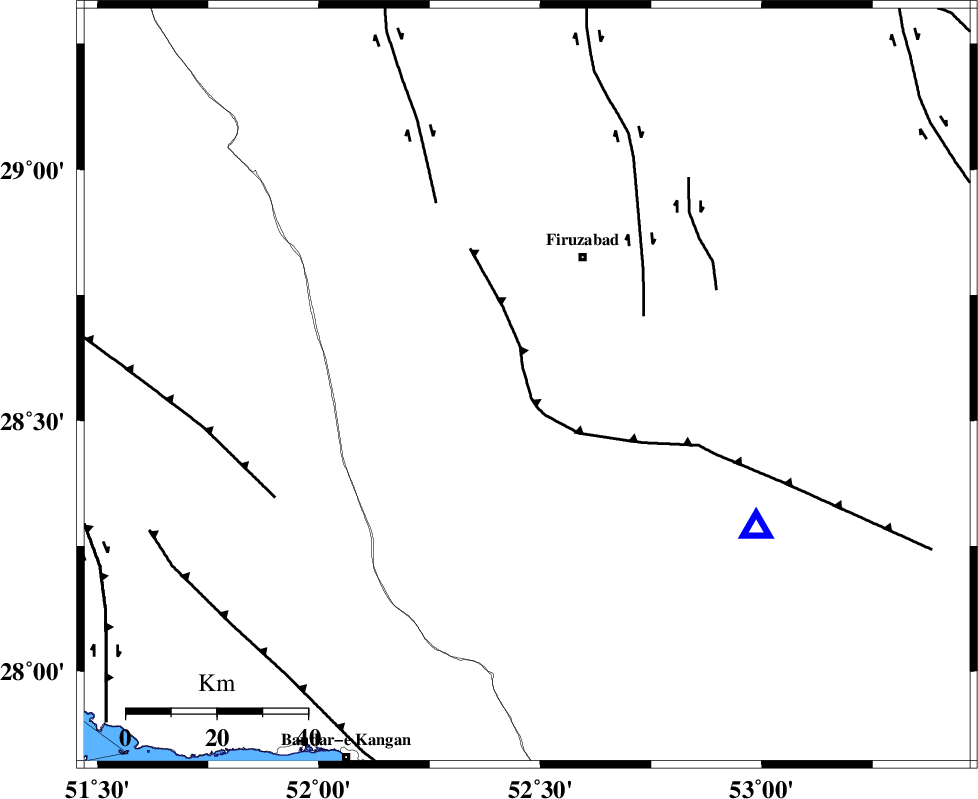
| Location | Lat:28.57 Lon: 52.47 |
| Region | Fars Province, 31 km South-West of Firuz Abad |
Nearest Cities |
|
| 18 km North East of Dahrom, Fars Province | |
| 27 km South West of Jaydasht, Fars Province | |
| 27 km South of Ahmadabad, Fars Province | |
| 29 km North West of Hengam, Fars Province | |
| 31 km South West of Firuz Abad, Fars Province | |
| Depth | 7 km |
| Agency | |
Faults within 150 km: |
|
| QIR_F (Length: 130 km) , Distance to epicenter: 3 km | |
| SABZ_PUSHAN_F_Z1 (Length: 69 km) , Distance to epicenter: 30 km | |
| KAREBASS_F (Length: 98 km) , Distance to epicenter: 45 km | |
| Number of Phases | 5 |
| RMS | 0.3 |
| Number of Stations | 5 |
| Error in Latitude | >7.8 km |
| Error in Longitude | 5.6 km |
| Error in Depth | 9.2 km |
Download waveform in seisan format
to download seisan software Click here
to access information about IIEES stations Click here
Amplitude | ||||||||
| UID | Agency | Station | Component | Amplitude | Period | Arrival Time | Proccessing Time | Signal Clip |
| 82584 | IIEES | GHIR | E | 1072.5 | 0.48 | 2012-03-29 06:17:12 | 2012-03-29 06:59:00 | n |
| 82585 | IIEES | GHIR | N | 1058.9 | 0.68 | 2012-03-29 06:17:18 | 2012-03-29 06:59:00 | n |
| 82586 | IIEES | AHRM | N | 589.2 | 0.39 | 2012-03-29 06:17:33 | 2012-03-29 06:59:00 | n |
| 82587 | IIEES | AHRM | E | 416.6 | 0.55 | 2012-03-29 06:17:35 | 2012-03-29 06:59:00 | n |
Phase | ||||||||||||
| Agency | Station | Component | Phase Type | Phase Quality | First Motion | Observed Arrival Time | Time Residual | Loc. Flag | Input Weight | Distance | Azimuth | |
| IIEES | GHIR | Z | Pg | E | 2012-03-29 06:16:57 | -0.05 | y | 59.7 | 122 | |||
| IIEES | AHRM | Z | Pg | E | 2012-03-29 06:17:07 | 0.06 | y | 119 | 286 | |||
| IIEES | BNDS | Z | Pn | E | 2012-03-29 06:17:43 | 0.01 | y | 387 | 109 | |||
| IIEES | NASN | Z | Pn | E | 2012-03-29 06:17:54 | -0.35 | y | 470 | 4 | |||
| IIEES | TABS | Z | Pn | E | 2012-03-29 06:18:25 | 0.56 | y | 717 | 37 | |||