
Magnitude |
:3.4 |
| Date & Time (UTC) | 2012-02-16 21:00:41.6 |
| Date & Time (Local) | 1390/11/28 00:30:41.6 |
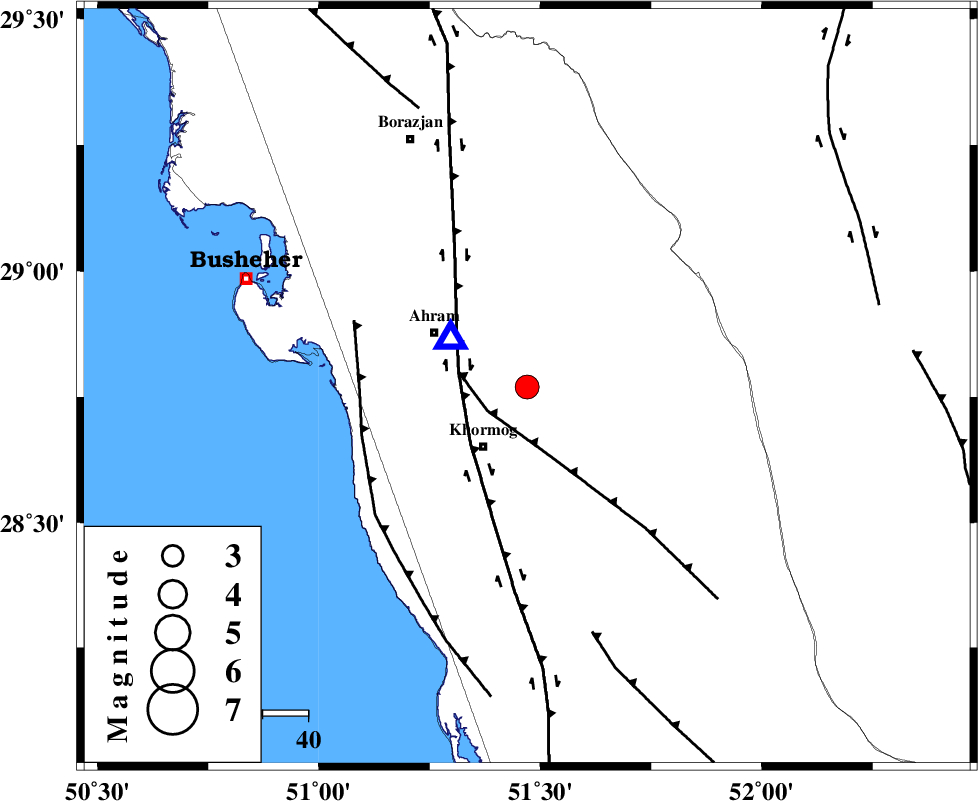
| Location | Lat:28.77 Lon: 51.47 |
| Region | Bushehr Province, 16 km North of Khormog |
Nearest Cities |
|
| 16 km North of Khormog, Bushehr Province | |
| 19 km South of Kalameh, Bushehr Province | |
| 22 km North East of Buheyri, Bushehr Province | |
| 24 km South East of Ahram, Bushehr Province | |
| 27 km South East of Bazuei, Bushehr Province | |
| Depth | 16 km |
| Agency | |
Faults within 150 km: |
|
| MFF5 (Length: 74 km) , Distance to epicenter: 10 km | |
| BORAZJAN_F (Length: 168 km) , Distance to epicenter: 15 km | |
| ZFF2 (Length: 84 km) , Distance to epicenter: 37 km | |
| Number of Phases | 6 |
| RMS | 0.3 |
| Number of Stations | 5 |
| Error in Latitude | >7.8 km |
| Error in Longitude | 5.8 km |
| Error in Depth | 4.8 km |
Download waveform in seisan format
to download seisan software Click here
to access information about IIEES stations Click here
Amplitude | ||||||||
| UID | Agency | Station | Component | Amplitude | Period | Arrival Time | Proccessing Time | Signal Clip |
| 81900 | IIEES | AHRM | E | 2877.4 | 0.32 | 2012-02-16 21:00:51 | 2012-02-16 08:18:00 | n |
| 81901 | IIEES | GHIR | E | 1065 | 0.48 | 2012-02-16 21:01:31 | 2012-02-16 08:18:00 | n |
| 81902 | IIEES | GHIR | N | 1046.3 | 0.64 | 2012-02-16 21:01:33 | 2012-02-16 08:18:00 | n |
Phase | ||||||||||||
| Agency | Station | Component | Phase Type | Phase Quality | First Motion | Observed Arrival Time | Time Residual | Loc. Flag | Input Weight | Distance | Azimuth | |
| IIEES | AHRM | Z | Pg | E | 2012-02-16 21:00:46 | -0.01 | y | 20 | 304 | |||
| IIEES | GHIR | Z | Pn | E | 2012-02-16 21:01:08 | -0.02 | y | 158 | 109 | |||
| IIEES | GHIR | E | Sg | E | 2012-02-16 21:01:27 | 0.03 | y | 158 | 109 | |||
| IIEES | NASN | N | Pn | E | 2012-02-16 21:01:47 | -0.22 | y | 465 | 16 | |||
| IIEES | KHMZ | N | Pn | E | 2012-02-16 21:02:00 | 0.54 | y | 570 | 346 | |||
| IIEES | SNGE | Z | Pn | E | 2012-02-16 21:02:28 | -0.42 | y | 802 | 332 | |||