
Magnitude |
:2.7 |
| Date & Time (UTC) | 2011-08-31 12:40:14.9 |
| Date & Time (Local) | 1390/6/9 17:10:14.9 |
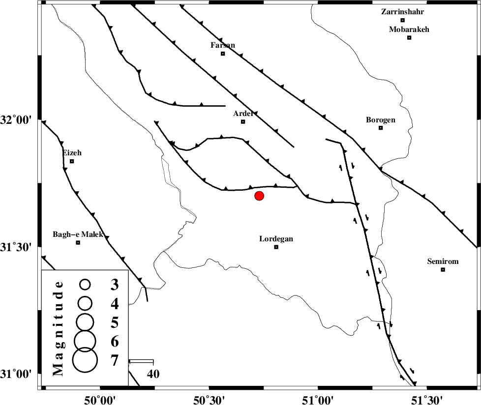
| Location | Lat:31.7 Lon: 50.73 |
| Region | Chaharmahal Bakhtiari Province, 24 km North of Lordegan |
Nearest Cities |
|
| 9 km North of Armand-e olia, Chaharmahal Bakhtiari Province | |
| 18 km East of Sarkhun, Chaharmahal Bakhtiari Province | |
| 24 km North of Lordegan, Chaharmahal Bakhtiari Province | |
| 27 km South of Naghan, Chaharmahal Bakhtiari Province | |
| 27 km South East of Dupelan, Chaharmahal Bakhtiari Province | |
| Depth | 14 km |
| Agency | |
Faults within 150 km: |
|
| SABZKUH_F (Length: 67 km) , Distance to epicenter: 4 km | |
| DOPOLAN_F (Length: 107 km) , Distance to epicenter: 14 km | |
| ARDAL_F (Length: 170 km) , Distance to epicenter: 26 km | |
| Number of Phases | 7 |
| RMS | 0.1 |
| Number of Stations | 5 |
| Error in Latitude | >2 km |
| Error in Longitude | 2.4 km |
| Error in Depth | 4.8 km |
Download waveform in seisan format
to download seisan software Click here
to access information about IIEES stations Click here
Amplitude | ||||||||
| UID | Agency | Station | Component | Amplitude | Period | Arrival Time | Proccessing Time | Signal Clip |
| 80126 | IIEES | SHGR | E | 113.4 | 0.48 | 2011-08-31 12:41:22 | 2011-08-31 01:43:00 | n |
| 80127 | IIEES | SHGR | N | 70.2 | 0.44 | 2011-08-31 12:41:22 | 2011-08-31 01:43:00 | n |
| 80128 | IIEES | KHMZ | N | 33.6 | 0.4 | 2011-08-31 12:41:26 | 2011-08-31 01:43:00 | n |
| 80129 | IIEES | KHMZ | E | 42.1 | 0.44 | 2011-08-31 12:41:27 | 2011-08-31 01:43:00 | n |
Phase | ||||||||||||
| Agency | Station | Component | Phase Type | Phase Quality | First Motion | Observed Arrival Time | Time Residual | Loc. Flag | Input Weight | Distance | Azimuth | |
| IIEES | SHGR | Z | Pg | E | 2011-08-31 12:40:45 | 0 | y | 188 | 284 | |||
| IIEES | SHGR | N | Sg | E | 2011-08-31 12:41:08 | -0.02 | y | 188 | 284 | |||
| IIEES | NASN | Z | Pn | E | 2011-08-31 12:40:51 | 0.02 | y | 231 | 58 | |||
| IIEES | KHMZ | Z | Pn | E | 2011-08-31 12:40:52 | 0.13 | y | 237 | 343 | |||
| IIEES | KHMZ | N | Sg | E | 2011-08-31 12:41:22 | 0.01 | y | 237 | 343 | |||
| IIEES | GHVR | Z | Pn | E | 2011-08-31 12:41:01 | -0.15 | y | 312 | 9 | |||
| IIEES | ASAO | Z | Pn | E | 2011-08-31 12:41:02 | -0.01 | y | 322 | 348 | |||