
Magnitude |
:2.7 |
| Date & Time (UTC) | 2011-05-26 01:02:55.2 |
| Date & Time (Local) | 1390/3/5 05:32:55.2 |
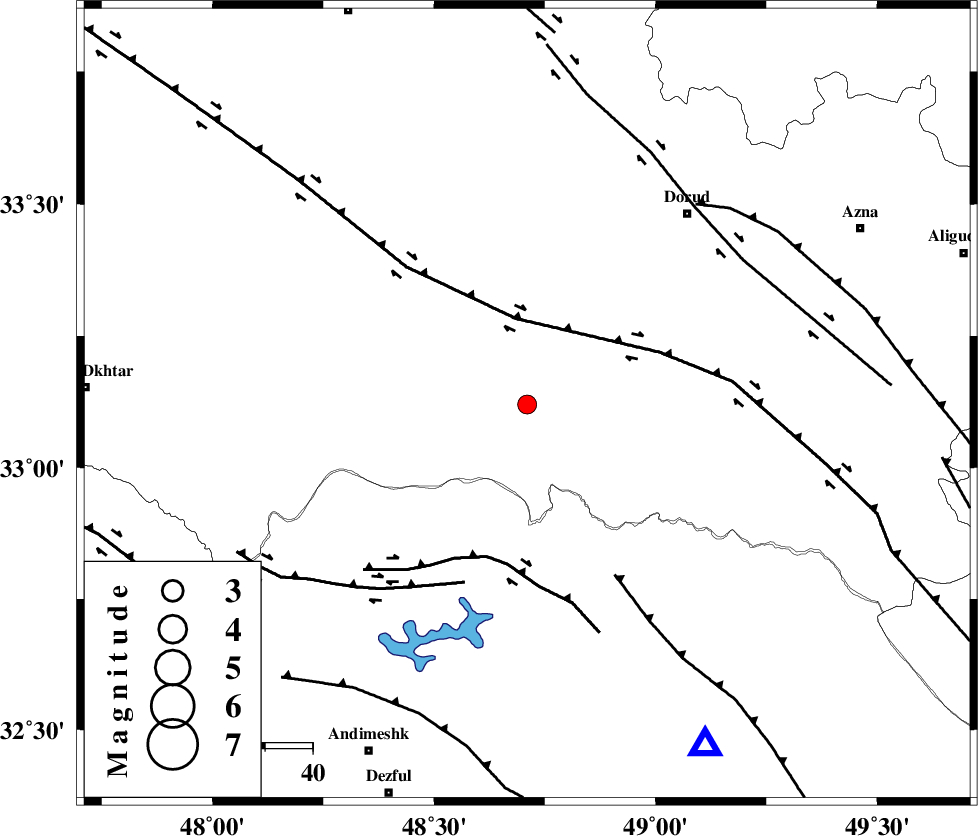
| Location | Lat:33.12 Lon: 48.71 |
| Region | Lorestan Province, 51 km South-East of Khorramabad |
Nearest Cities |
|
| 12 km West of Chamsangar, Lorestan Province | |
| 23 km North West of Bargsar, Lorestan Province | |
| 29 km South West of Sartang barzeh, Lorestan Province | |
| 31 km South of Emanabad, Lorestan Province | |
| 37 km North West of Shuy, Khoozestan Province | |
| Depth | 14 km |
| Agency | |
Faults within 150 km: |
|
| HZF4 (Length: 492 km) , Distance to epicenter: 18 km | |
| BALARUD_F_Z2 (Length: 58 km) , Distance to epicenter: 33 km | |
| BALARUD_F_Z3 (Length: 53 km) , Distance to epicenter: 40 km | |
| Number of Phases | 5 |
| RMS | 0.1 |
| Number of Stations | 4 |
| Error in Latitude | >1.6 km |
| Error in Longitude | 3.7 km |
| Error in Depth | 5.7 km |
Download waveform in seisan format
to download seisan software Click here
to access information about IIEES stations Click here
Amplitude | ||||||||
| UID | Agency | Station | Component | Amplitude | Period | Arrival Time | Proccessing Time | Signal Clip |
| 79102 | IIEES | SHGR | E | 227.9 | 0.32 | 2011-05-26 01:03:33 | 2011-05-26 01:18:00 | n |
| 79103 | IIEES | SHGR | N | 193.5 | 0.6 | 2011-05-26 01:03:37 | 2011-05-26 01:18:00 | n |
| 79104 | IIEES | ASAO | E | 51 | 0.68 | 2011-05-26 01:03:57 | 2011-05-26 01:18:00 | n |
| 79105 | IIEES | ASAO | N | 58.7 | 0.64 | 2011-05-26 01:04:00 | 2011-05-26 01:18:00 | n |
| 79106 | IIEES | SNGE | E | 35.6 | 0.52 | 2011-05-26 01:04:14 | 2011-05-26 01:18:00 | n |
| 79107 | IIEES | SNGE | N | 50.7 | 0.56 | 2011-05-26 01:04:18 | 2011-05-26 01:18:00 | n |
| 79108 | IIEES | GHVR | E | 38.2 | 0.44 | 2011-05-26 01:04:17 | 2011-05-26 01:18:00 | n |
| 79109 | IIEES | GHVR | N | 32 | 0.48 | 2011-05-26 01:04:18 | 2011-05-26 01:18:00 | n |
Phase | ||||||||||||
| Agency | Station | Component | Phase Type | Phase Quality | First Motion | Observed Arrival Time | Time Residual | Loc. Flag | Input Weight | Distance | Azimuth | |
| IIEES | SHGR | Z | P | E | 2011-05-26 01:03:14 | 0 | y | 113 | 176 | |||
| IIEES | ASAO | Z | P | E | 2011-05-26 01:03:27 | 0.1 | y | 200 | 37 | |||
| IIEES | ASAO | N | Sg | E | 2011-05-26 01:03:52 | -0.1 | y | 200 | 37 | |||
| IIEES | SNGE | Z | P | E | 2011-05-26 01:03:34 | 0 | y | 252 | 330 | |||
| IIEES | GHVR | Z | P | E | 2011-05-26 01:03:37 | 0 | y | 279 | 57 | |||