
Magnitude |
:2.7 |
| Date & Time (UTC) | 2010-11-15 16:41:06.2 |
| Date & Time (Local) | 1389/8/24 20:11:06.2 |
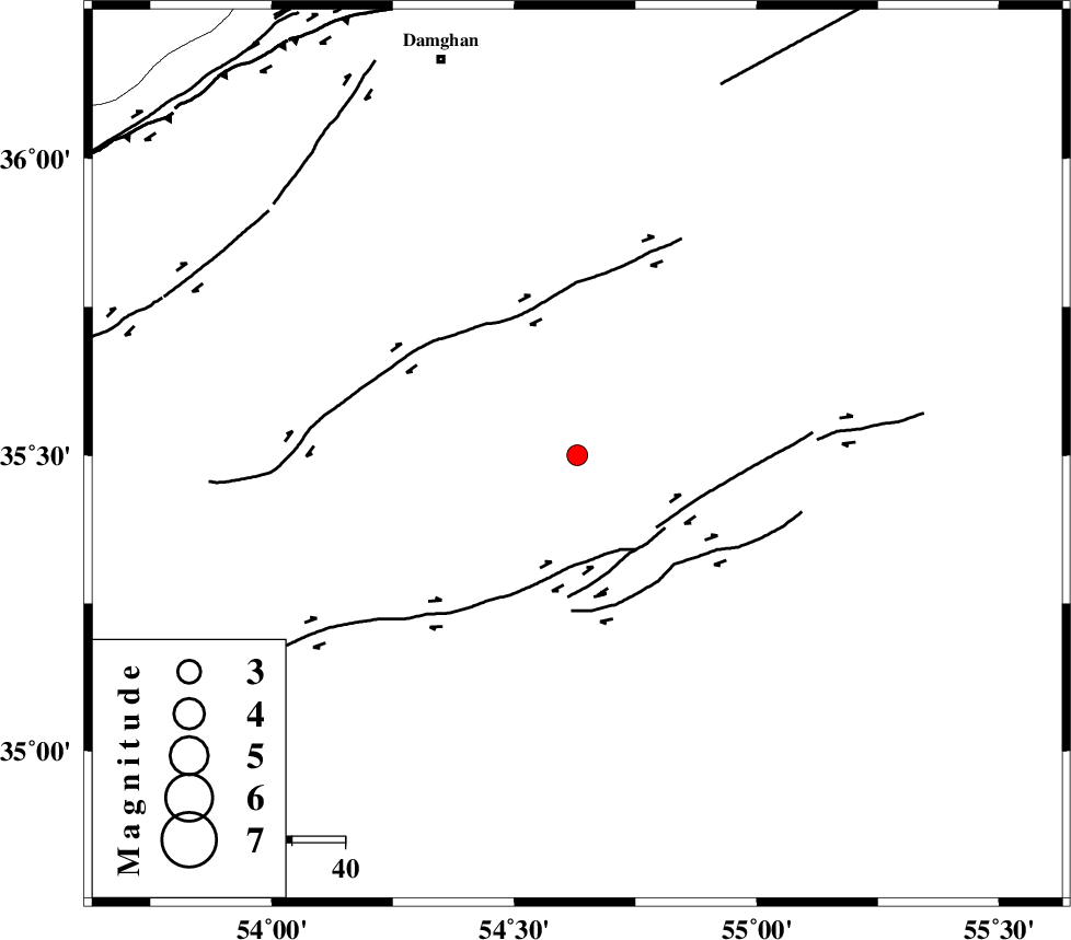
| Location | Lat:35.5 Lon: 54.63 |
| Region | Semnan Province, 78 km South-East of Damghan |
Nearest Cities |
|
| 73 km South East of Amirabad, Semnan Province | |
| 75 km South East of Seydabad, Semnan Province | |
| 78 km South East of Damghan, Semnan Province | |
| 80 km South of Mehmandust, Semnan Province | |
| 85 km South East of Darvar, Semnan Province | |
| Depth | 15 km |
| Agency | |
Faults within 150 km: |
|
| TORUD_F (Length: 136 km) , Distance to epicenter: 18 km | |
| MEYAMEY_F (Length: 141 km) , Distance to epicenter: 74 km | |
| ATARI_F (Length: 185 km) , Distance to epicenter: 81 km | |
| Number of Phases | 5 |
| RMS | 0.5 |
| Number of Stations | 5 |
| Error in Latitude | >7.6 km |
| Error in Longitude | 4.8 km |
| Error in Depth | 0 km |
Download waveform in seisan format
to download seisan software Click here
to access information about IIEES stations Click here
Amplitude | ||||||||
| UID | Agency | Station | Component | Amplitude | Period | Arrival Time | Proccessing Time | Signal Clip |
| 73510 | IIEES | SHRO | N | 117.8 | 0.56 | 2010-11-15 16:41:56 | 2010-11-15 05:07:00 | n |
| 73511 | IIEES | SHRO | E | 88.7 | 0.48 | 2010-11-15 16:41:56 | 2010-11-15 05:07:00 | n |
| 73512 | IIEES | DAMV | E | 78.1 | 0.28 | 2010-11-15 16:42:18 | 2010-11-15 05:07:00 | n |
| 73513 | IIEES | DAMV | N | 52.5 | 0.4 | 2010-11-15 16:42:20 | 2010-11-15 05:07:00 | n |
Phase | ||||||||||||
| Agency | Station | Component | Phase Type | Phase Quality | First Motion | Observed Arrival Time | Time Residual | Loc. Flag | Input Weight | Distance | Azimuth | |
| IIEES | SHRO | Z | Pn | E | 2010-11-15 16:41:30 | -0.7 | y | 137 | 65 | |||
| IIEES | DAMV | Z | Pn | E | 2010-11-15 16:41:43 | -0.3 | y | 242 | 274 | |||
| IIEES | MRVT | N | Pn | E | 2010-11-15 16:41:48 | 0.7 | y | 273 | 28 | |||
| IIEES | TABS | Z | Pn | E | 2010-11-15 16:41:52 | 0.2 | y | 307 | 131 | |||
| IIEES | NASN | Z | Pn | E | 2010-11-15 16:41:56 | 0.1 | y | 343 | 210 | |||