
Magnitude |
:5 |
| Date & Time (UTC) | 2010-08-11 17:26:19.7 |
| Date & Time (Local) | 1389/5/20 21:56:19.7 |
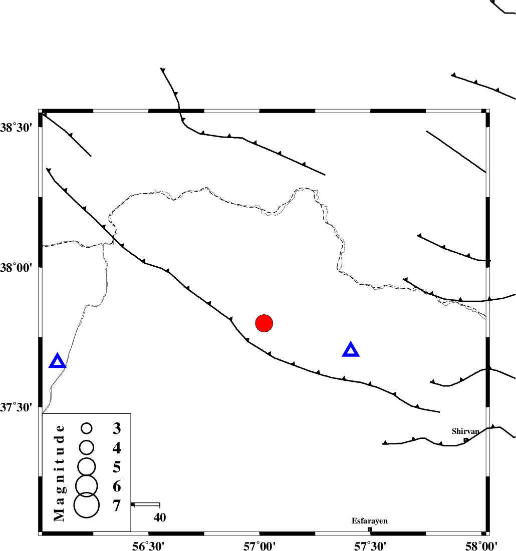
| Location | Lat:37.8 Lon: 57.02 |
| Region | Khorasan(north) Province, 29 km North of Ashkhaneh |
Nearest Cities |
|
| 16 km North of Pish qaleh, Khorasan(north) Province | |
| 18 km South West of Raz, Khorasan(north) Province | |
| 18 km South of Tangehzar, Khorasan(north) Province | |
| 29 km North of Ashkhaneh, Khorasan(north) Province | |
| 42 km West of Gifan olia, Khorasan(north) Province | |
| Depth | 15 km |
| Agency | |
Faults within 150 km: |
|
| ROBATE_QARABIL_F (Length: 168 km) , Distance to epicenter: 50 km | |
| BAGHAN_GERMAB_F (Length: 79 km) , Distance to epicenter: 53 km | |
| ESFARAYEN_F (Length: 111 km) , Distance to epicenter: 62 km | |
| Number of Phases | 8 |
| RMS | 0.1 |
| Number of Stations | 7 |
| Error in Latitude | >1.6 km |
| Error in Longitude | 1.6 km |
| Error in Depth | 2.3 km |
Download waveform in seisan format
to download seisan software Click here
to access information about IIEES stations Click here
Amplitude | ||||||||
| UID | Agency | Station | Component | Amplitude | Period | Arrival Time | Proccessing Time | Signal Clip |
| 68470 | IIEES | MRVT | E | 49744.4 | 0.2 | 2010-08-11 17:26:48 | 2010-08-11 05:40:00 | n |
| 68471 | IIEES | MRVT | N | 74395.2 | 0.4 | 2010-08-11 17:26:50 | 2010-08-11 05:40:00 | n |
| 68472 | IIEES | TABS | N | 1408.5 | 0.72 | 2010-08-11 17:28:39 | 2010-08-11 05:40:00 | n |
Phase | ||||||||||||
| Agency | Station | Component | Phase Type | Phase Quality | First Motion | Observed Arrival Time | Time Residual | Loc. Flag | Input Weight | Distance | Azimuth | |
| IIEES | BJRD | Z | P | E | 2010-08-11 17:26:26 | 0 | y | 36.2 | 108 | |||
| IIEES | MRVT | Z | P | E | 2010-08-11 17:26:34 | 0 | y | 83.3 | 260 | |||
| IIEES | SHRO | Z | P | E | 2010-08-11 17:26:54 | 0 | y | 218 | 205 | |||
| IIEES | SHRO | N | Sg | E | 2010-08-11 17:27:21 | 0 | y | 218 | 205 | |||
| IIEES | TABS | Z | P | E | 2010-08-11 17:27:24 | 0 | y | 461 | 179 | |||
| IIEES | GHVR | Z | P | E | 2010-08-11 17:27:46 | 0.1 | y | 637 | 236 | |||
| IIEES | ZNJK | Z | Pn | E | 2010-08-11 17:28:00 | 0 | y | 750 | 263 | |||
| IIEES | KHMZ | Z | P | E | 2010-08-11 17:28:04 | -0.1 | y | 780 | 237 | |||