
Magnitude |
:3.4 |
| Date & Time (UTC) | 2010-07-02 04:24:38.2 |
| Date & Time (Local) | 1389/4/11 08:54:38.2 |
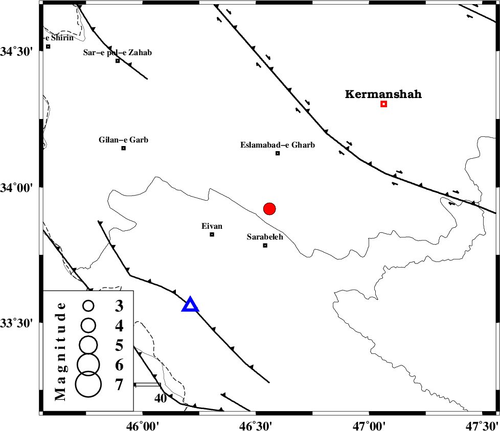
| Location | Lat:33.92 Lon: 46.56 |
| Region | Kermanshah Province, 16 km North of Sar Ableh |
Nearest Cities |
|
| 11 km North of Mohammadqoli, Ilam Province | |
| 15 km North of Sar Ableh, Ilam Province | |
| 20 km West of Hamil, Kermanshah Province | |
| 21 km South West of Qale-ye shahin, Kermanshah Province | |
| 21 km North West of Darbid-e mansuri, Kermanshah Province | |
| Depth | 15 km |
| Agency | |
Faults within 150 km: |
|
| HZF4 (Length: 492 km) , Distance to epicenter: 39 km | |
| MFF7 (Length: 99 km) , Distance to epicenter: 51 km | |
| MFF8 (Length: 48 km) , Distance to epicenter: 72 km | |
| Number of Phases | 5 |
| RMS | 0.3 |
| Number of Stations | 3 |
| Error in Latitude | >4.4 km |
| Error in Longitude | 7.4 km |
| Error in Depth | 0 km |
Download waveform in seisan format
to download seisan software Click here
to access information about IIEES stations Click here
Amplitude | ||||||||
| UID | Agency | Station | Component | Amplitude | Period | Arrival Time | Proccessing Time | Signal Clip |
| 65279 | IIEES | SNGE | E | 757 | 0.5 | 2010-07-02 04:25:28 | 2010-07-04 02:01:00 | n |
| 65280 | IIEES | SNGE | N | 638.1 | 0.13 | 2010-07-02 04:25:30 | 2010-07-04 02:01:00 | n |
Phase | ||||||||||||
| Agency | Station | Component | Phase Type | Phase Quality | First Motion | Observed Arrival Time | Time Residual | Loc. Flag | Input Weight | Distance | Azimuth | |
| IIEES | SNGE | Z | Pg | E | 2010-07-02 04:25:02 | -0.5 | y | 149 | 29 | |||
| IIEES | SNGE | N | Sg | E | 2010-07-02 04:25:21 | 0.4 | y | 149 | 29 | |||
| IIEES | KHMZ | Z | Pn | E | 2010-07-02 04:25:25 | 0.3 | y | 316 | 93 | |||
| IIEES | ASAO | Z | Pn | E | 2010-07-02 04:25:26 | 0.1 | y | 327 | 77 | |||
| IIEES | ASAO | N | Sg | E | 2010-07-02 04:26:10 | -0.2 | y | 327 | 77 | |||