
Magnitude |
:3.3 |
| Date & Time (UTC) | 2004-11-15 03:11:52.4 |
| Date & Time (Local) | 1383/8/25 06:41:52.4 |
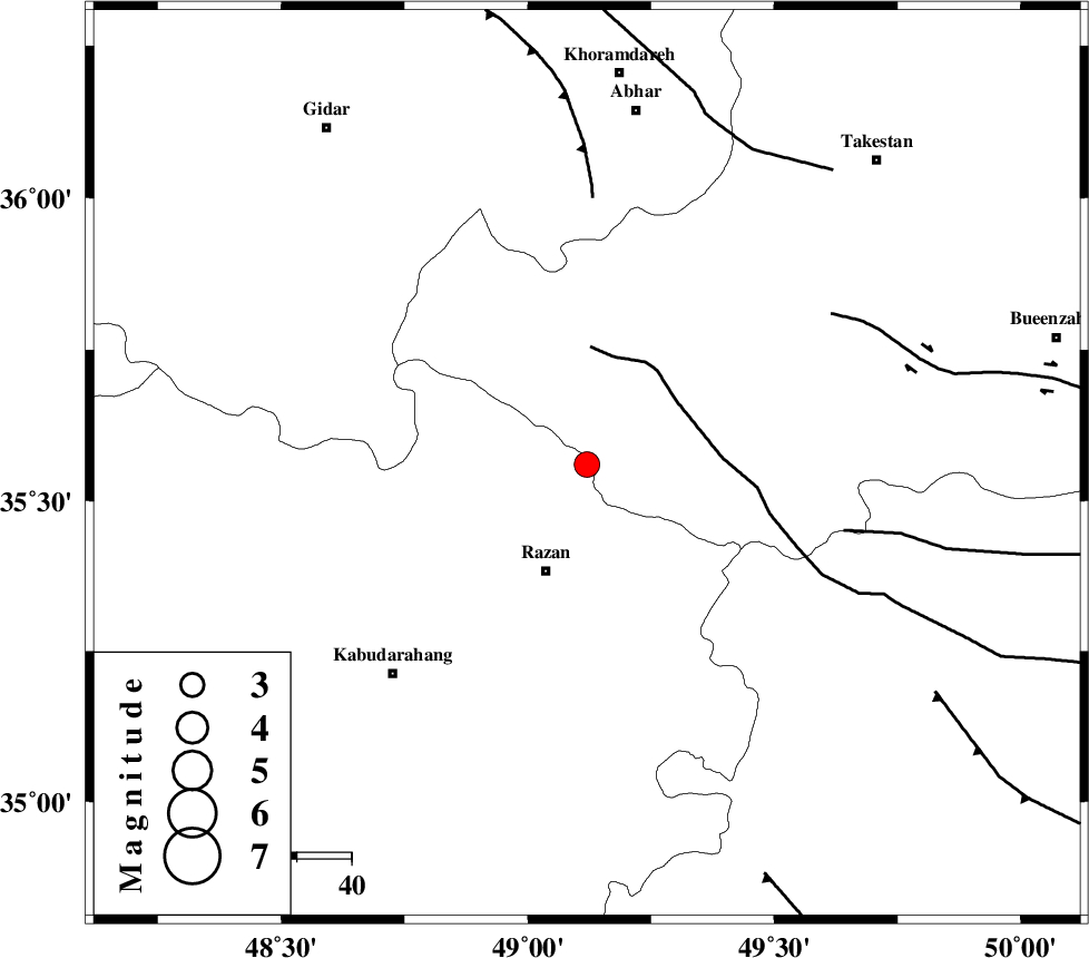
| Location | Lat:35.56 Lon: 49.12 |
| Region | 21 km North of Razan, Hamedan Province |
Nearest Cities |
|
| 11 km West of Avaj, Ghazvin Province | |
| 21 km North of Razan, Hamedan Province | |
| 27 km South West of Ab-e garm, Ghazvin Province | |
| 28 km North of Gorvey-edarjezin, Hamedan Province | |
| 30 km North East of Khorandeh, Hamedan Province | |
| Depth | 14 km |
| Agency | |
Faults within 150 km: |
|
| KUSHK_E_NOSRAT_F (Length: 230 km) , Distance to epicenter: 20 km | |
| S_PARANDAK_F (Length: 116 km) , Distance to epicenter: 49 km | |
| SOLTANIYEH_F (Length: 119 km) , Distance to epicenter: 49 km | |
| Number of Phases | 5 |
| RMS | 0.2 |
| Number of Stations | 4 |
| Error in Latitude | >6.9 km |
| Error in Longitude | 3.1 km |
| Error in Depth | 8.5 km |
Download waveform in seisan format
to download seisan software Click here
to access information about IIEES stations Click here
Amplitude | ||||||||
| UID | Agency | Station | Component | Amplitude | Period | Arrival Time | Proccessing Time | Signal Clip |
| 30963 | IIEES | THKV | E | 407.6 | 0.51 | 2004-11-15 03:12:50 | 2006-03-15 11:56:00 | n |
| 30964 | IIEES | THKV | N | 420.7 | 0.56 | 2004-11-15 03:12:53 | 2006-03-15 11:56:00 | n |
| 30965 | IIEES | SNGE | N | 379.2 | 0.57 | 2004-11-15 03:12:47 | 2006-03-15 11:56:00 | n |
| 30966 | IIEES | DAMV | E | 196.7 | 0.5 | 2004-11-15 03:13:08 | 2006-03-15 11:56:00 | n |
| 30967 | IIEES | DAMV | N | 214.8 | 0.53 | 2004-11-15 03:13:14 | 2006-03-15 11:56:00 | n |
| 30968 | IIEES | GRMI | E | 65.5 | 0.57 | 2004-11-15 03:13:38 | 2006-03-15 11:56:00 | n |
| 30969 | IIEES | GRMI | N | 50.7 | 0.37 | 2004-11-15 03:13:39 | 2006-03-15 11:56:00 | n |
Phase | ||||||||||||
| Agency | Station | Component | Phase Type | Phase Quality | First Motion | Observed Arrival Time | Time Residual | Loc. Flag | Input Weight | Distance | Azimuth | |
| IIEES | THKV | Z | PG | E | 2004-11-15 03:12:19 | -0.2 | y | 164 | 76 | |||
| IIEES | SNGE | Z | PG | E | 2004-11-15 03:12:20 | -0.1 | y | 169 | 253 | |||
| IIEES | SNGE | N | SG | E | 2004-11-15 03:12:41 | 0 | y | 169 | 253 | |||
| IIEES | DAMV | Z | PN | E | 2004-11-15 03:12:32 | 0.3 | y | 258 | 87 | |||
| IIEES | GRMI | Z | PN | E | 2004-11-15 03:12:47 | 0.1 | y | 377 | 344 | |||