
Magnitude |
:2.2 |
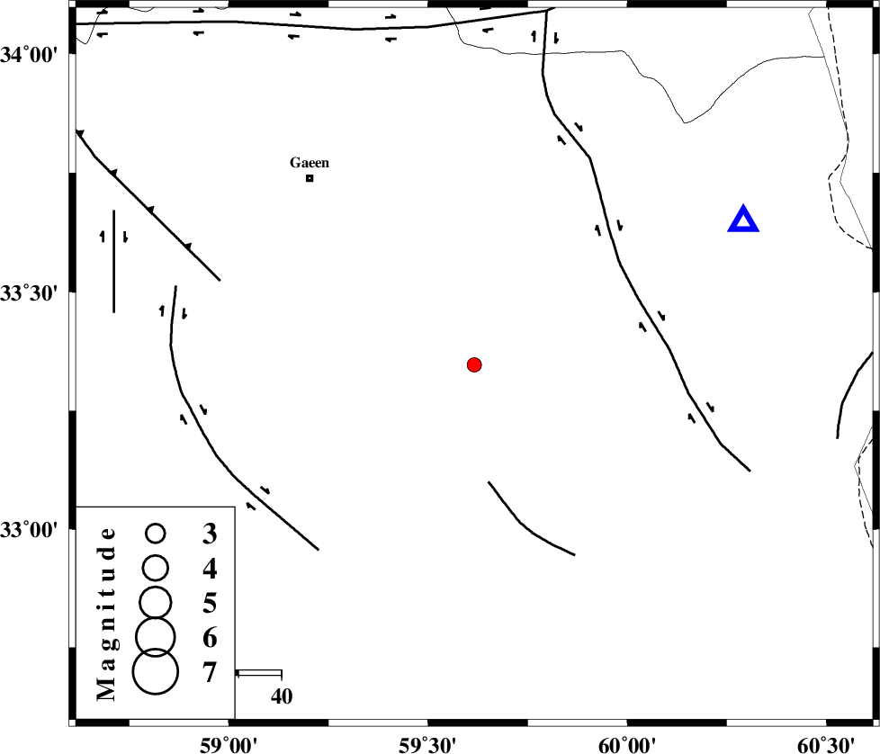
| Date & Time (UTC) | 2015-09-11 11:28:23.7 |
| Date & Time (Local) | 1394/6/20 15:58:23.7 |
| Location | Lat:33.347 Lon: 59.616 |
| Region | Khorasan(south) Province, 58 km South-East of Qaen |
Nearest Cities |
|
| 18 km West of Zahan, Khorasan(south) Province | |
| 19 km North East of Gazar, Khorasan(south) Province | |
| 22 km North of Derakhsh, Khorasan(south) Province | |
| 27 km South East of Khoshk, Khorasan(south) Province | |
| 35 km North of Gasak, Khorasan(south) Province | |
| Depth | 15 km |
| Agency | |
Faults within 150 km: |
|
| NOZAD_F (Length: 27 km) , Distance to epicenter: 28 km | |
| ABRIZ_F (Length: 114 km) , Distance to epicenter: 41 km | |
| MOHAMMADABAD_F (Length: 71 km) , Distance to epicenter: 57 km | |
| Number of Phases | 4 |
| RMS | 0 |
| Number of Stations | 3 |
| Error in Latitude | >1.9 km |
| Error in Longitude | 1.4 km |
| Error in Depth | 4 km |
Download waveform in seisan format
to download seisan software Click here
to access information about IIEES stations Click here
Amplitude | ||||||||
| UID | Agency | Station | Component | Amplitude | Period | Arrival Time | Proccessing Time | Signal Clip |
| 100882 | IIEES | BSRN | N | 24.6 | 0.22 | 2015-09-11 11:29:16 | 2015-09-13 06:47:00 | n |
| 100883 | IIEES | TABS | N | 25.9 | 0.67 | 2015-09-11 11:29:36 | 2015-09-13 06:47:00 | n |
| 100884 | IIEES | TABS | E | 14.2 | 0.45 | 2015-09-11 11:29:37 | 2015-09-13 06:47:00 | n |
Phase | ||||||||||||
| Agency | Station | Component | Phase Type | Phase Quality | First Motion | Observed Arrival Time | Time Residual | Loc. Flag | Input Weight | Distance | Azimuth | |
| IIEES | SHRT | Z | Pg | E | 2015-09-11 11:28:36 | 0 | y | 71 | 62 | |||
| IIEES | BSRN | Z | Pg | E | 2015-09-11 11:28:50 | 0 | y | 160 | 197 | |||
| IIEES | TABS | Z | Pn | E | 2015-09-11 11:29:00 | 0.01 | y | 234 | 279 | |||
| IIEES | TABS | E | Sg | E | 2015-09-11 11:29:30 | -0.02 | y | 234 | 279 | |||