
Magnitude |
:3.4 |
| Date & Time (UTC) | 2015-09-11 08:13:02.6 |
| Date & Time (Local) | 1394/6/20 12:43:02.6 |
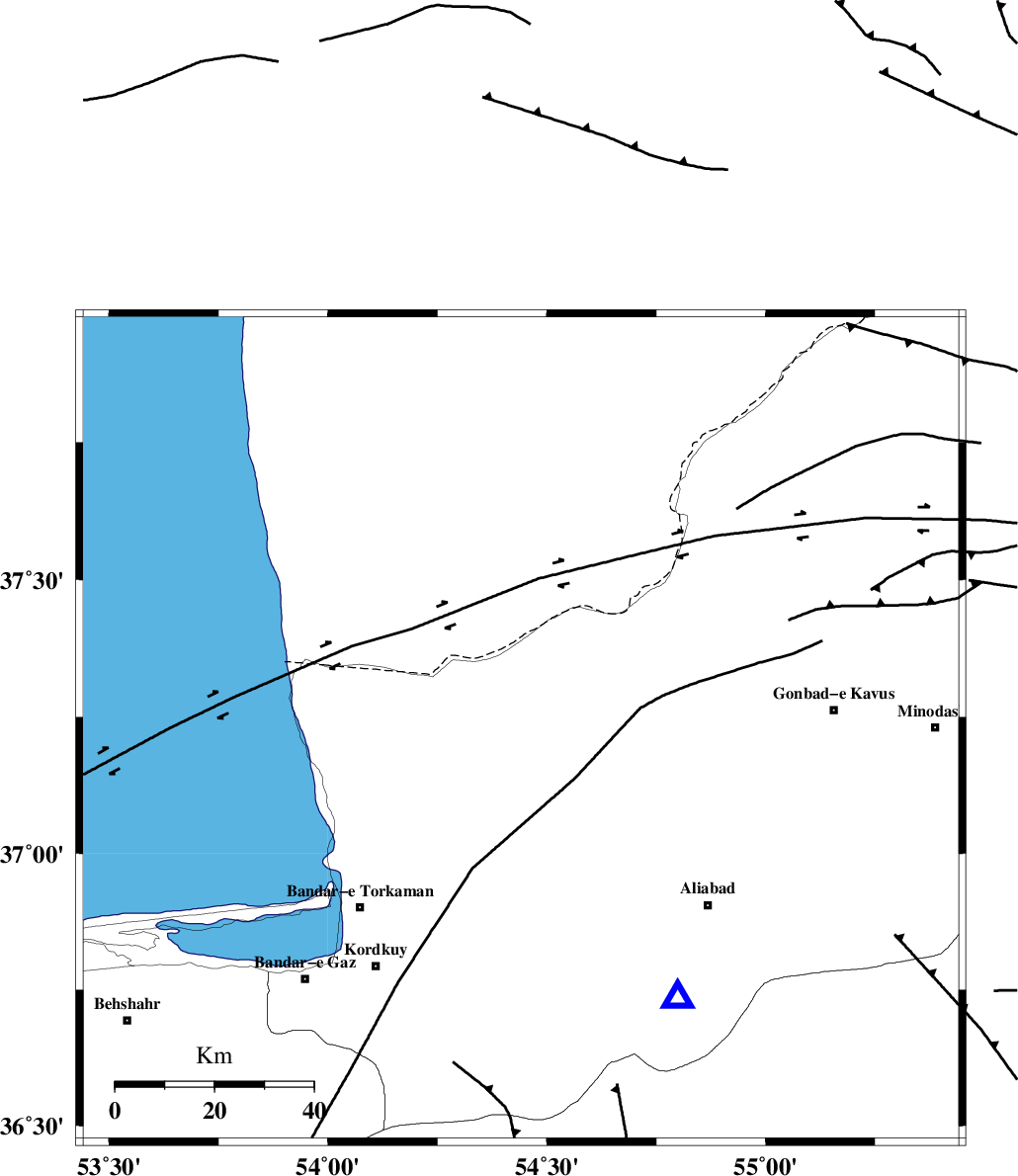
| Location | Lat:37.227 Lon: 54.441 |
| Region | Golestan Province, 24 km North of Aq Qaleh |
Nearest Cities |
|
| 24 km North of Aq Qaleh, Golestan Province | |
| 24 km North of Qanqarmeh, Golestan Province | |
| 31 km North West of Gariduji, Golestan Province | |
| 31 km North East of Banavar, Golestan Province | |
| 31 km North West of Nodeh malek, Golestan Province | |
| Depth | 15 km |
| Agency | |
Faults within 150 km: |
|
| KHAZAR_F (Length: 523 km) , Distance to epicenter: 42 km | |
| N_ALBORZ_F (Length: 360 km) , Distance to epicenter: 69 km | |
| SHAVAR_F (Length: 87 km) , Distance to epicenter: 73 km | |
| Number of Phases | 7 |
| RMS | 0.4 |
| Number of Stations | 7 |
| Error in Latitude | >5.1 km |
| Error in Longitude | 6.8 km |
| Error in Depth | 8.9 km |
Download waveform in seisan format
to download seisan software Click here
to access information about IIEES stations Click here
Amplitude | ||||||||
| UID | Agency | Station | Component | Amplitude | Period | Arrival Time | Proccessing Time | Signal Clip |
| 100818 | IIEES | MRVT | E | 553.3 | 0.23 | 2015-09-11 08:13:49 | 2015-09-12 07:32:00 | n |
| 100819 | IIEES | MRVT | N | 538.2 | 0.31 | 2015-09-11 08:13:50 | 2015-09-12 07:32:00 | n |
Phase | ||||||||||||
| Agency | Station | Component | Phase Type | Phase Quality | First Motion | Observed Arrival Time | Time Residual | Loc. Flag | Input Weight | Distance | Azimuth | |
| IIEES | MRVT | Z | Pg | E | 2015-09-11 08:13:28 | 0.36 | y | 154 | 71 | |||
| IIEES | SHRO | Z | Pg | E | 2015-09-11 08:13:34 | -0.46 | y | 195 | 133 | |||
| IIEES | BJRD | Z | Pn | E | 2015-09-11 08:13:43 | -0.24 | y | 268 | 78 | |||
| IIEES | YZKH | Z | Pn | E | 2015-09-11 08:14:17 | 0.59 | y | 537 | 178 | |||
| IIEES | GRMI | Z | Pn | E | 2015-09-11 08:14:24 | -0.27 | y | 601 | 289 | |||
| IIEES | SHRT | Z | Pn | E | 2015-09-11 08:14:32 | 0.05 | y | 663 | 125 | |||
| IIEES | BSRN | Z | Pn | E | 2015-09-11 08:14:40 | 0.21 | y | 725 | 142 | |||