
Magnitude |
:2.5 |
| Date & Time (UTC) | 2015-09-05 05:27:49.4 |
| Date & Time (Local) | 1394/6/14 09:57:49.4 |
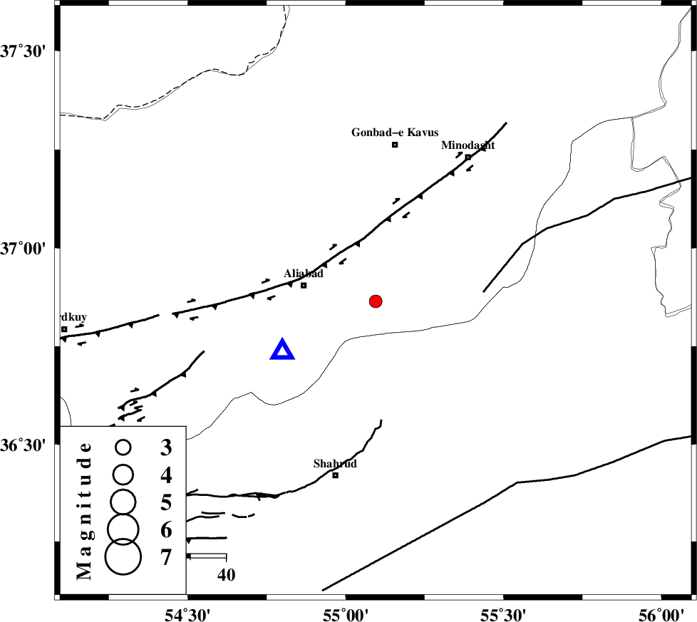
| Location | Lat:36.864 Lon: 55.095 |
| Region | Golestan Province, 17 km South of Ramian |
Nearest Cities |
|
| 17 km South of Ramian, Golestan Province | |
| 19 km South East of Khanbebin, Golestan Province | |
| 20 km South of Deland, Golestan Province | |
| 21 km East of Ali Abad, Golestan Province | |
| 25 km South West of Khanduz, Golestan Province | |
| Depth | 14 km |
| Agency | |
Faults within 150 km: |
|
| SHAVAR_F (Length: 87 km) , Distance to epicenter: 13 km | |
| KHAZAR_F (Length: 523 km) , Distance to epicenter: 20 km | |
| ROBATE_QARABIL_F (Length: 168 km) , Distance to epicenter: 30 km | |
| Number of Phases | 5 |
| RMS | 0.2 |
| Number of Stations | 3 |
| Error in Latitude | >1.8 km |
| Error in Longitude | 9.5 km |
| Error in Depth | 7.4 km |
Download waveform in seisan format
to download seisan software Click here
to access information about IIEES stations Click here
Amplitude | ||||||||
| UID | Agency | Station | Component | Amplitude | Period | Arrival Time | Proccessing Time | Signal Clip |
| 100682 | IIEES | MRVT | E | 81.4 | 0.27 | 2015-09-05 05:28:32 | 2015-09-05 06:59:00 | n |
| 100683 | IIEES | MRVT | N | 87.9 | 0.33 | 2015-09-05 05:28:34 | 2015-09-05 06:59:00 | n |
| 100684 | IIEES | BJRD | E | 73.2 | 0.29 | 2015-09-05 05:29:03 | 2015-09-05 06:59:00 | n |
Phase | ||||||||||||
| Agency | Station | Component | Phase Type | Phase Quality | First Motion | Observed Arrival Time | Time Residual | Loc. Flag | Input Weight | Distance | Azimuth | |
| IIEES | MRVT | Z | Pg | E | 2015-09-05 05:28:10 | 0.03 | y | 125 | 45 | |||
| IIEES | MRVT | N | Sg | E | 2015-09-05 05:28:25 | -0.14 | y | 125 | 45 | |||
| IIEES | SHRO | Z | Pg | E | 2015-09-05 05:28:10 | -0.32 | y | 126 | 139 | |||
| IIEES | SHRO | E | Sg | E | 2015-09-05 05:28:26 | 0.15 | y | 126 | 139 | |||
| IIEES | BJRD | Z | Pn | E | 2015-09-05 05:28:25 | 0.28 | y | 225 | 65 | |||