
Magnitude |
:3.1 |
| Date & Time (UTC) | 2015-08-27 12:18:13.7 |
| Date & Time (Local) | 1394/6/5 16:48:13.7 |
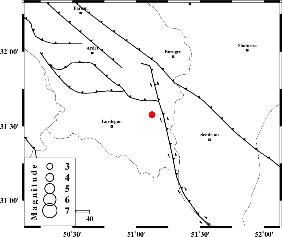
| Location | Lat:31.578 Lon: 51.122 |
| Region | Chaharmahal Bakhtiari Province, 31 km -East of Lordegan |
Nearest Cities |
|
| 7 km North of Aluni, Chaharmahal Bakhtiari Province | |
| 21 km North West of Vanak, Esfahan Province | |
| 31 km North East of Lordegan, Chaharmahal Bakhtiari Province | |
| 32 km East of Armand-e olia, Chaharmahal Bakhtiari Province | |
| 32 km South of Gandoman, Chaharmahal Bakhtiari Province | |
| Depth | 18 km |
| Agency | |
Faults within 150 km: |
|
| DENA_F (Length: 137 km) , Distance to epicenter: 9 km | |
| DOPOLAN_F (Length: 107 km) , Distance to epicenter: 11 km | |
| SABZKUH_F (Length: 67 km) , Distance to epicenter: 27 km | |
| Number of Phases | 6 |
| RMS | 0.3 |
| Number of Stations | 4 |
| Error in Latitude | >3.5 km |
| Error in Longitude | 4.8 km |
| Error in Depth | 9.3 km |
Download waveform in seisan format
to download seisan software Click here
to access information about IIEES stations Click here
Amplitude | ||||||||
| UID | Agency | Station | Component | Amplitude | Period | Arrival Time | Proccessing Time | Signal Clip |
| 100553 | IIEES | NASN | N | 155.7 | 0.64 | 2015-08-27 12:19:19 | 2015-08-29 09:10:00 | n |
Phase | ||||||||||||
| Agency | Station | Component | Phase Type | Phase Quality | First Motion | Observed Arrival Time | Time Residual | Loc. Flag | Input Weight | Distance | Azimuth | |
| IIEES | NASN | Z | Pn | E | 2015-08-27 12:18:46 | -0.44 | y | 209 | 49 | |||
| IIEES | NASN | N | Sg | E | 2015-08-27 12:19:13 | 0.28 | y | 209 | 49 | |||
| IIEES | AHRM | Z | P | E | 2015-08-27 12:18:58 | 0.24 | y | 301 | 177 | |||
| IIEES | GHVR | Z | Pn | E | 2015-08-27 12:19:01 | 0.06 | y | 322 | 2 | |||
| IIEES | GHVR | N | Sg | E | 2015-08-27 12:19:44 | 0.05 | y | 322 | 2 | |||
| IIEES | YZKH | Z | Pn | E | 2015-08-27 12:19:03 | -0.18 | y | 340 | 74 | |||