
Magnitude |
:2.7 |
| Date & Time (UTC) | 2015-04-16 02:50:07.0 |
| Date & Time (Local) | 1394/1/27 07:20:07.0 |
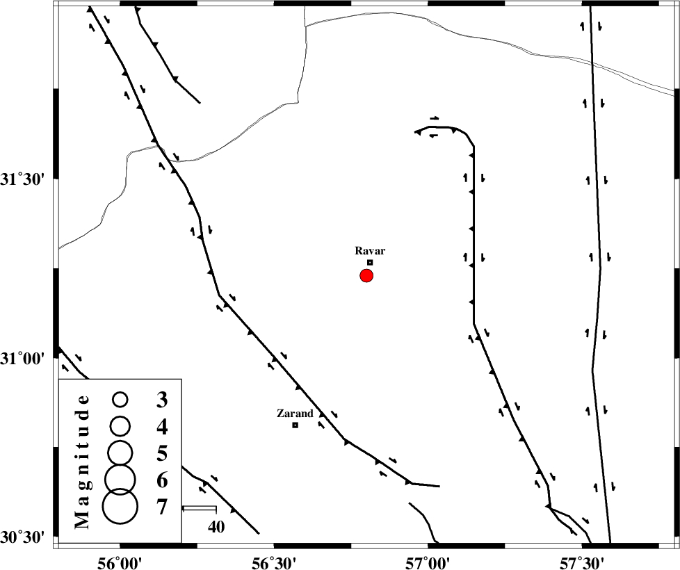
| Location | Lat:31.23 Lon: 56.8 |
| Region | Kerman Province, 4 km Ravar |
Nearest Cities |
|
| 4 km of Ravar, Kerman Province | |
| 10 km of Dehali, Kerman Province | |
| 29 km North East of Ahmadi, Kerman Province | |
| 30 km North East of Dasht-e khak, Kerman Province | |
| 37 km North East of Toghroljerd, Kerman Province | |
| Depth | 14 km |
| Agency | |
Faults within 150 km: |
|
| LAKARKUH_F (Length: 138 km) , Distance to epicenter: 36 km | |
| KUHBANAN_F (Length: 189 km) , Distance to epicenter: 38 km | |
| CHATRUD_F (Length: 37 km) , Distance to epicenter: 72 km | |
| Number of Phases | 4 |
| RMS | 0.1 |
| Number of Stations | 3 |
| Error in Latitude | >2.8 km |
| Error in Longitude | 3.1 km |
| Error in Depth | 6.2 km |
Download waveform in seisan format
to download seisan software Click here
to access information about IIEES stations Click here
Amplitude | ||||||||
| UID | Agency | Station | Component | Amplitude | Period | Arrival Time | Proccessing Time | Signal Clip |
| 95435 | IIEES | KRBR | E | 133.6 | 0.24 | 2015-04-16 02:50:51 | 2015-04-16 03:44:00 | n |
| 95436 | IIEES | YZKH | E | 43.3 | 0.36 | 2015-04-16 02:51:19 | 2015-04-16 03:44:00 | n |
| 95437 | IIEES | YZKH | N | 50.4 | 0.28 | 2015-04-16 02:51:20 | 2015-04-16 03:44:00 | n |
Phase | ||||||||||||
| Agency | Station | Component | Phase Type | Phase Quality | First Motion | Observed Arrival Time | Time Residual | Loc. Flag | Input Weight | Distance | Azimuth | |
| IIEES | KRBR | Z | Pg | E | 2015-04-16 02:50:30 | -0.02 | y | 139 | 182 | |||
| IIEES | BSRN | Z | Pn | E | 2015-04-16 02:50:43 | -0.03 | y | 235 | 69 | |||
| IIEES | YZKH | Z | Pn | E | 2015-04-16 02:50:45 | 0.14 | y | 245 | 302 | |||
| IIEES | YZKH | N | Sg | E | 2015-04-16 02:51:16 | -0.08 | y | 245 | 302 | |||