
Magnitude |
:4.3 |
| Date & Time (UTC) | 2015-03-08 18:43:33.1 |
| Date & Time (Local) | 1393/12/17 22:13:33.1 |
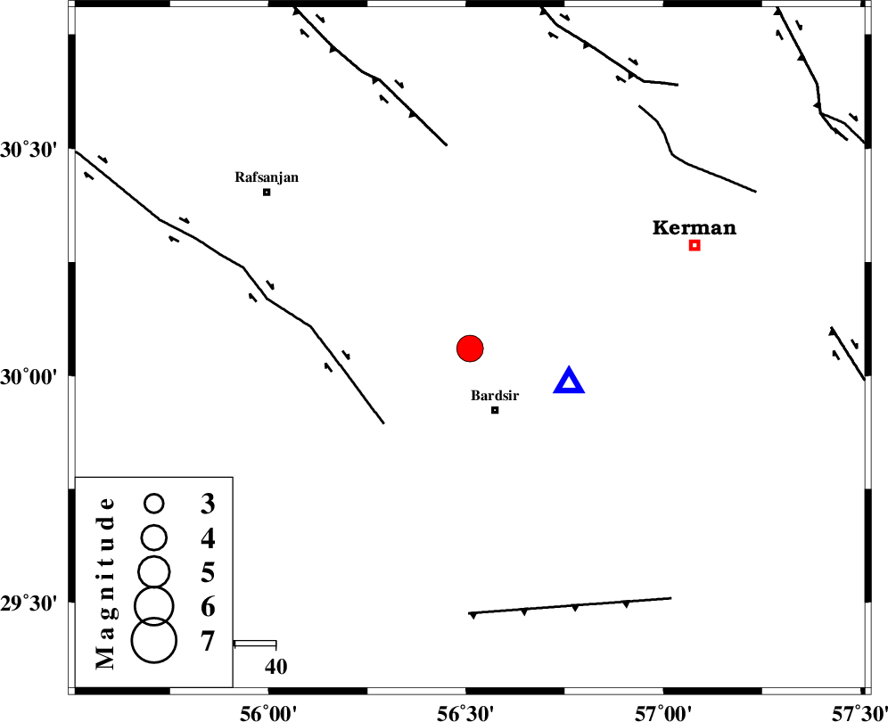
| Location | Lat:30.06 Lon: 56.51 |
| Region | Kerman Province, 16 km North of Bardsir |
Nearest Cities |
|
| 16 km North East of Mahutak, Kerman Province | |
| 16 km North of Bardsir, Kerman Province | |
| 23 km North West of Dashtkar, Kerman Province | |
| 30 km South East of Kabutarkhan, Kerman Province | |
| 32 km South West of Baghin, Kerman Province | |
| Depth | 14 km |
| Agency | |
Faults within 150 km: |
|
| RAFSANJAN_F (Length: 129 km) , Distance to epicenter: 28 km | |
| DARIVAN_F (Length: 131 km) , Distance to epicenter: 50 km | |
| LALEHZAR_F (Length: 52 km) , Distance to epicenter: 65 km | |
| Number of Phases | 6 |
| RMS | 0.2 |
| Number of Stations | 5 |
| Error in Latitude | >2.9 km |
| Error in Longitude | 3.6 km |
| Error in Depth | 3.7 km |
Download waveform in seisan format
to download seisan software Click here
to access information about IIEES stations Click here
Amplitude | ||||||||
| UID | Agency | Station | Component | Amplitude | Period | Arrival Time | Proccessing Time | Signal Clip |
| 95196 | IIEES | KRBR | N | 109000 | 0.2 | 2015-03-08 18:43:42 | 2015-03-08 07:05:00 | n |
| 95197 | IIEES | KRBR | E | 80498.8 | 0.16 | 2015-03-08 18:43:42 | 2015-03-08 07:05:00 | n |
| 95198 | IIEES | YZKH | E | 467.9 | 0.36 | 2015-03-08 18:45:08 | 2015-03-08 07:05:00 | n |
| 95199 | IIEES | YZKH | N | 679.6 | 0.72 | 2015-03-08 18:45:09 | 2015-03-08 07:05:00 | n |
Phase | ||||||||||||
| Agency | Station | Component | Phase Type | Phase Quality | First Motion | Observed Arrival Time | Time Residual | Loc. Flag | Input Weight | Distance | Azimuth | |
| IIEES | KRBR | Z | Pg | E | 2015-03-08 18:43:38 | -0.19 | y | 25.2 | 109 | |||
| IIEES | BNDS | Z | Pn | E | 2015-03-08 18:44:17 | 0.08 | y | 296 | 187 | |||
| IIEES | YZKH | Z | Pn | E | 2015-03-08 18:44:20 | -0.14 | y | 317 | 325 | |||
| IIEES | YZKH | E | Sg | E | 2015-03-08 18:45:02 | 0.1 | y | 317 | 325 | |||
| IIEES | ZHSF | Z | Pn | E | 2015-03-08 18:44:32 | 0.28 | y | 415 | 96 | |||
| IIEES | NASN | Z | Pn | E | 2015-03-08 18:44:38 | -0.09 | y | 465 | 312 | |||