
Magnitude |
:3 |
| Date & Time (UTC) | 2014-06-26 16:22:08.6 |
| Date & Time (Local) | 1393/4/5 20:52:08.6 |
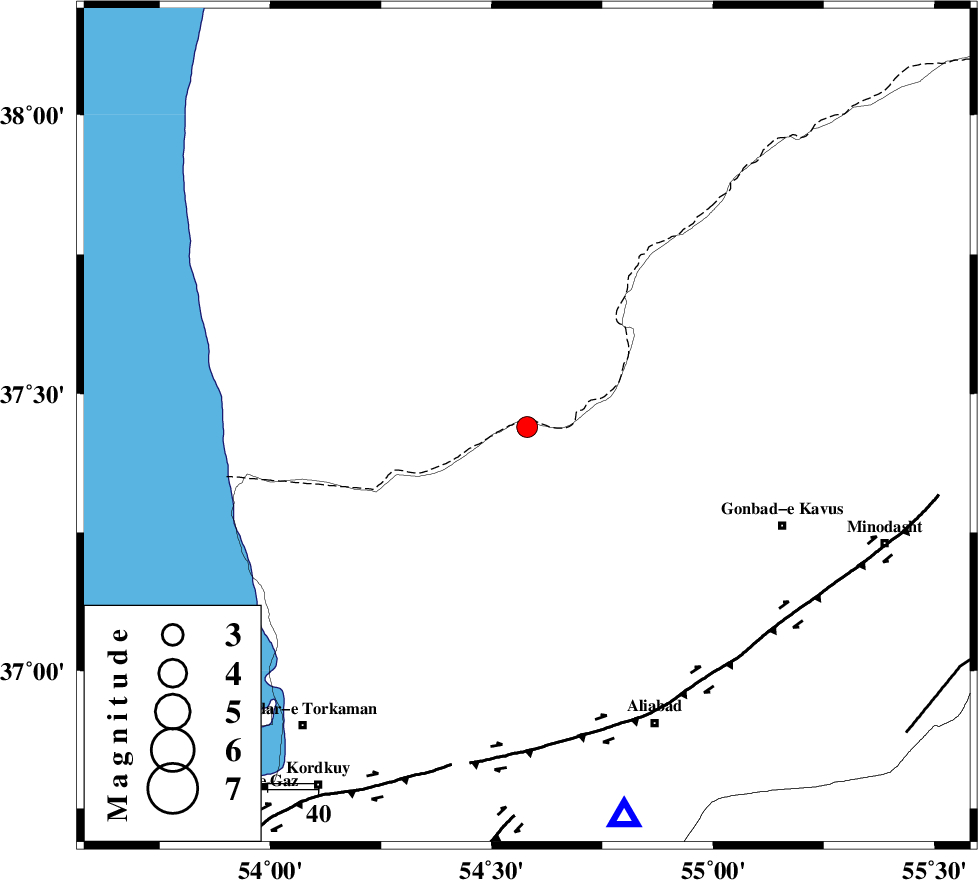
| Location | Lat:37.44 Lon: 54.58 |
| Region | Golestan Province, 48 km North-East of Aq Qaleh |
Nearest Cities |
|
| 13 km West of Enchehborun, Golestan Province | |
| 30 km South West of Dashliborun, Golestan Province | |
| 42 km North West of Gariduji, Golestan Province | |
| 48 km North of Qanqarmeh, Golestan Province | |
| 49 km North East of Aq Qaleh, Golestan Province | |
| Depth | 14 km |
| Agency | |
Faults within 150 km: |
|
| KHAZAR_F (Length: 523 km) , Distance to epicenter: 59 km | |
| SHAVAR_F (Length: 87 km) , Distance to epicenter: 91 km | |
| N_ALBORZ_F (Length: 360 km) , Distance to epicenter: 94 km | |
| Number of Phases | 4 |
| RMS | 0.1 |
| Number of Stations | 3 |
| Error in Latitude | >6.7 km |
| Error in Longitude | 6.6 km |
| Error in Depth | 7 km |
Download waveform in seisan format
to download seisan software Click here
to access information about IIEES stations Click here
Amplitude | ||||||||
| UID | Agency | Station | Component | Amplitude | Period | Arrival Time | Proccessing Time | Signal Clip |
| 92682 | IIEES | SHRO | E | 152.4 | 0.24 | 2014-06-26 16:23:07 | 2014-06-26 06:08:00 | n |
Phase | ||||||||||||
| Agency | Station | Component | Phase Type | Phase Quality | First Motion | Observed Arrival Time | Time Residual | Loc. Flag | Input Weight | Distance | Azimuth | |
| IIEES | SHRO | Z | Pn | E | 2014-06-26 16:22:41 | 0.04 | y | 204 | 141 | |||
| IIEES | SHRO | E | Sg | E | 2014-06-26 16:23:06 | -0.03 | y | 204 | 141 | |||
| IIEES | YZKH | Z | Pn | E | 2014-06-26 16:23:26 | 0.05 | y | 560 | 180 | |||
| IIEES | GRMI | Z | Pn | E | 2014-06-26 16:23:31 | -0.08 | y | 605 | 287 | |||