
Magnitude |
:2.7 |
| Date & Time (UTC) | 2012-09-22 03:52:39.6 |
| Date & Time (Local) | 1391/7/1 07:22:39.6 |
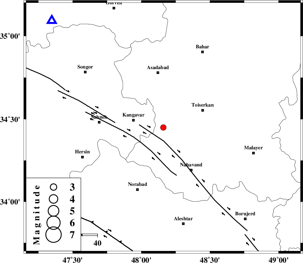
| Location | Lat:34.45 Lon: 48.16 |
| Region | Hamedan Province, 21 km East of Kangavar |
Nearest Cities |
|
| 10 km North of Firuzan, Hamedan Province | |
| 11 km of Gudin, Kermanshah Province | |
| 12 km West of Farsang, Hamedan Province | |
| 20 km North of Shahrak, Hamedan Province | |
| 20 km East of Kangavar, Kermanshah Province | |
| Depth | 31 km |
| Agency | |
Faults within 150 km: |
|
| NAHAVAND_F (Length: 102 km) , Distance to epicenter: 9 km | |
| SAHANEH_F (Length: 77 km) , Distance to epicenter: 18 km | |
| DINEHVAR_F (Length: 46 km) , Distance to epicenter: 32 km | |
| Number of Phases | 5 |
| RMS | 0 |
| Number of Stations | 3 |
| Error in Latitude | >3.1 km |
| Error in Longitude | 2 km |
| Error in Depth | 3.6 km |
Download waveform in seisan format
to download seisan software Click here
to access information about IIEES stations Click here
Amplitude | ||||||||
| UID | Agency | Station | Component | Amplitude | Period | Arrival Time | Proccessing Time | Signal Clip |
| 86235 | IIEES | SNGE | E | 254.8 | 0.22 | 2012-09-22 03:53:14 | 2012-09-22 04:19:00 | n |
| 86236 | IIEES | ASAO | E | 119.1 | 0.44 | 2012-09-22 03:53:34 | 2012-09-22 04:19:00 | n |
| 86237 | IIEES | KHMZ | N | 73.6 | 0.39 | 2012-09-22 03:53:43 | 2012-09-22 04:19:00 | n |
Phase | ||||||||||||
| Agency | Station | Component | Phase Type | Phase Quality | First Motion | Observed Arrival Time | Time Residual | Loc. Flag | Input Weight | Distance | Azimuth | |
| IIEES | SNGE | Z | Pg | E | 2012-09-22 03:52:57 | 0.01 | y | 103 | 314 | |||
| IIEES | ASAO | Z | Pg | E | 2012-09-22 03:53:07 | -0.04 | y | 171 | 86 | |||
| IIEES | ASAO | E | Sg | E | 2012-09-22 03:53:28 | 0.02 | y | 171 | 86 | |||
| IIEES | KHMZ | Z | Pn | E | 2012-09-22 03:53:08 | 0 | y | 184 | 115 | |||
| IIEES | KHMZ | N | Sg | E | 2012-09-22 03:53:31 | 0.01 | y | 184 | 115 | |||