
Magnitude |
:2.6 |
| Date & Time (UTC) | 2015-09-18 21:00:05.4 |
| Date & Time (Local) | 1394/6/28 01:30:05.4 |
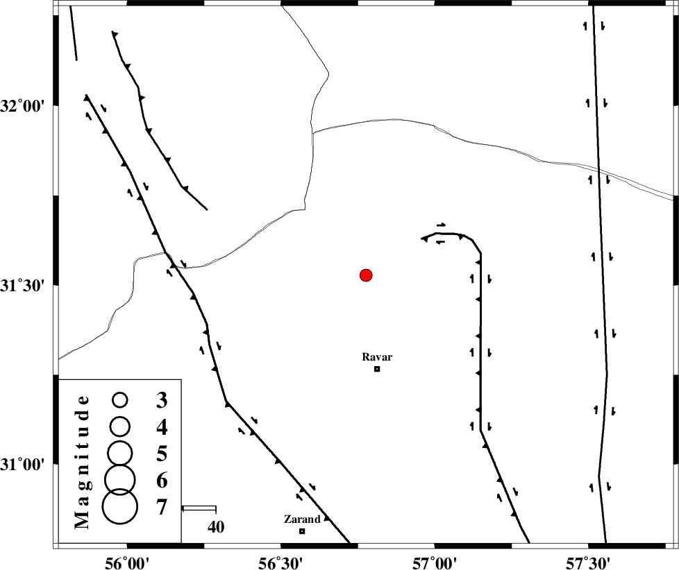
| Location | Lat:31.527 Lon: 56.776 |
| Region | Kerman Province, 29 km North of Ravar |
Nearest Cities |
|
| 23 km North of Dehali, Kerman Province | |
| 29 km North of Ravar, Kerman Province | |
| 47 km North East of Kuhbanan, Kerman Province | |
| 50 km North East of Jor, Kerman Province | |
| 54 km North East of Toghroljerd, Kerman Province | |
| Depth | 14 km |
| Agency | |
Faults within 150 km: |
|
| LAKARKUH_F (Length: 138 km) , Distance to epicenter: 20 km | |
| KUHBANAN_F (Length: 189 km) , Distance to epicenter: 51 km | |
| JAFARABAD_F (Length: 60 km) , Distance to epicenter: 53 km | |
| Number of Phases | 6 |
| RMS | 0.1 |
| Number of Stations | 3 |
| Error in Latitude | >1.4 km |
| Error in Longitude | 1.3 km |
| Error in Depth | 4.3 km |
Download waveform in seisan format
to download seisan software Click here
to access information about IIEES stations Click here
Amplitude | ||||||||
| UID | Agency | Station | Component | Amplitude | Period | Arrival Time | Proccessing Time | Signal Clip |
| 100987 | IIEES | KRBR | E | 85.1 | 0.16 | 2015-09-18 21:00:57 | 2015-09-19 08:32:00 | n |
| 100988 | IIEES | KRBR | N | 65.3 | 0.24 | 2015-09-18 21:00:57 | 2015-09-19 08:32:00 | n |
Phase | ||||||||||||
| Agency | Station | Component | Phase Type | Phase Quality | First Motion | Observed Arrival Time | Time Residual | Loc. Flag | Input Weight | Distance | Azimuth | |
| IIEES | KRBR | Z | Pg | E | 2015-09-18 21:00:33 | -0.25 | y | 171 | 181 | |||
| IIEES | KRBR | N | Sg | E | 2015-09-18 21:00:54 | 0.17 | y | 171 | 181 | |||
| IIEES | YZKH | Z | Pn | E | 2015-09-18 21:00:41 | 0.1 | y | 228 | 295 | |||
| IIEES | BSRN | Z | Pn | E | 2015-09-18 21:00:41 | -0.1 | y | 228 | 77 | |||
| IIEES | BSRN | N | Sg | E | 2015-09-18 21:01:10 | 0.08 | y | 228 | 77 | |||
| IIEES | YZKH | N | Sg | E | 2015-09-18 21:01:10 | 0 | y | 228 | 295 | |||