
Magnitude |
:3.9 |
| Date & Time (UTC) | 2026-02-11 23:56:23.9 |
| Date & Time (Local) | 1404/11/23 03:26:23.9 |
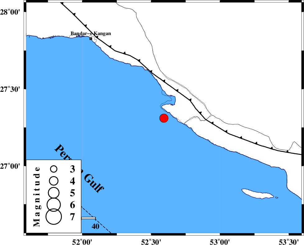
| Location | Lat:27.311 Lon: 52.592 |
| Region | Persian Gulf, 39 km South-West of Mehr |
Nearest Cities |
|
| 18 km South of Bandar-e asaluyeh, Bushehr Province | |
| 20 km West of Chah-e mobarak, Bushehr Province | |
| 37 km South West of Ardavan-e olia, Fars Province | |
| 39 km South of Gallehdar, Fars Province | |
| 39 km South West of Mehr, Fars Province | |
| Depth | 12 km |
| Agency | |
Faults within 150 km: |
|
| MFF3 (Length: 292 km) , Distance to epicenter: 23 km | |
| BORAZJAN_F (Length: 168 km) , Distance to epicenter: 124 km | |
| QIR_F (Length: 130 km) , Distance to epicenter: 127 km | |
| Number of Phases | 8 |
| RMS | 0.2 |
| Number of Stations | 8 |
| Error in Latitude | >2.8 km |
| Error in Longitude | 2.8 km |
| Error in Depth | 342.5 km |
Download waveform in seisan format
to download seisan software Click here
to access information about IIEES stations Click here
Amplitude | ||||||||
| UID | Agency | Station | Component | Amplitude | Period | Arrival Time | Proccessing Time | Signal Clip |
| 201611 | IIEES SC | UOSS | Z | 0.2 | 1 | 2026-02-11 23:57:27 | 2026-02-18 06:46:00 | n |
| 201612 | IIEES SC | KRVR | Z | 0.1 | 1 | 2026-02-11 23:57:50 | 2026-02-18 06:46:00 | n |
Phase | ||||||||||||
| Agency | Station | Component | Phase Type | Phase Quality | First Motion | Observed Arrival Time | Time Residual | Loc. Flag | Input Weight | Distance | Azimuth | |
| IIEES SC | GENO | Z | EPn | E | 2026-02-11 23:57:15 | -0.3 | y | 0 | 354 | 88 | ||
| IIEES SC | ABH1 | Z | EPn | E | 2026-02-11 23:57:25 | -0.2 | y | 0 | 430 | 328 | ||
| IIEES SC | UOSS | Z | EPn | E | 2026-02-11 23:57:27 | 0.2 | y | 0 | 446 | 126 | ||
| IIEES SC | BRJ | Z | EPn | E | 2026-02-11 23:57:37 | 0.2 | y | 0 | 526 | 346 | ||
| IIEES SC | KRVR | Z | EPn | E | 2026-02-11 23:57:50 | 0.2 | y | 0 | 635 | 41 | ||
| IIEES SC | IRSR | Z | EPn | E | 2026-02-11 23:58:14 | 0.2 | y | 0 | 821 | 93 | ||
| IIEES SC | SRVN | Z | EPn | E | 2026-02-11 23:58:32 | -0.4 | y | 0 | 970 | 89 | ||
| IIEES SC | GURO | Z | EPn | E | 2026-02-11 23:59:45 | -3.9 | n | 4 | 1590 | 322 | ||