
Magnitude |
:3.7 |
| Date & Time (UTC) | 2025-02-20 19:53:33.2 |
| Date & Time (Local) | 1403/12/2 23:23:33.2 |
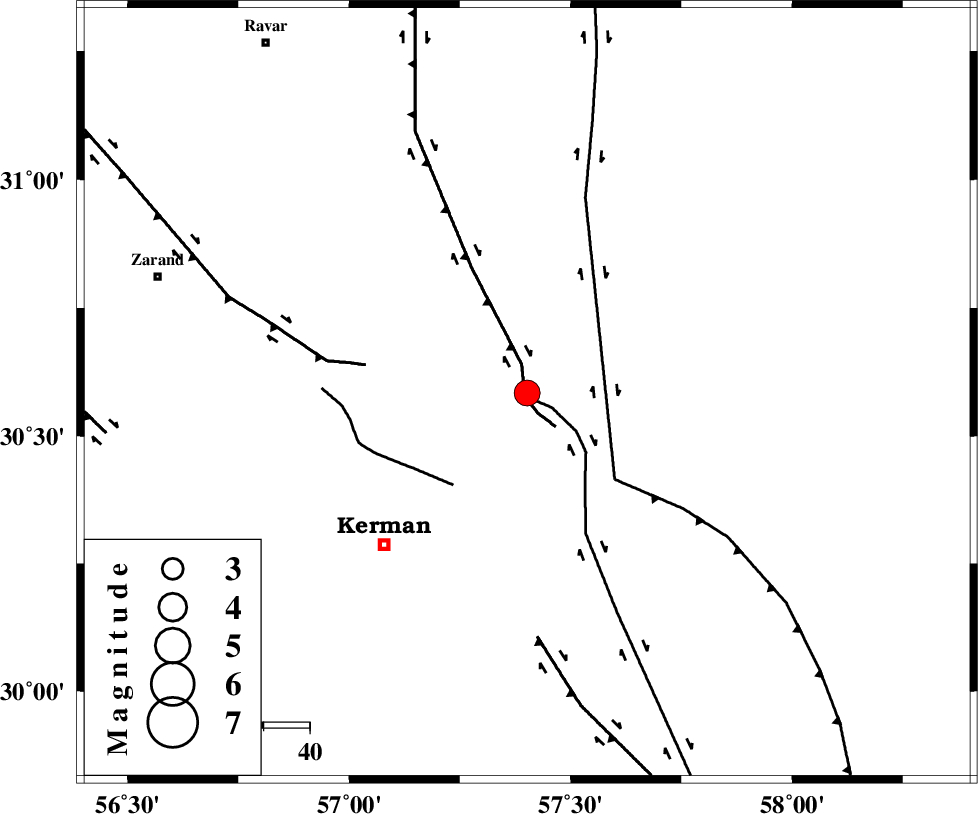
| Location | Lat:30.584 Lon: 57.402 |
| Region | Kerman Province, 45 km North-East of Kerman |
Nearest Cities |
|
| 15 km North East of Dehlulu, Kerman Province | |
| 27 km East of Harjand, Kerman Province | |
| 35 km North West of Shahdad, Kerman Province | |
| 42 km North East of Sarasiyab-e ferangi, Kerman Province | |
| 45 km North East of Hutak, Kerman Province | |
| Depth | 12 km |
| Agency | |
Faults within 150 km: |
|
| LAKARKUH_F (Length: 138 km) , Distance to epicenter: 1 km | |
| GOLBAF_SIRCH_F (Length: 114 km) , Distance to epicenter: 1 km | |
| CHATRUD_F (Length: 37 km) , Distance to epicenter: 26 km | |
| Number of Phases | 11 |
| RMS | 0.4 |
| Number of Stations | 11 |
| Error in Latitude | >3.4 km |
| Error in Longitude | 3.4 km |
| Error in Depth | 598.5 km |
Download waveform in seisan format
to download seisan software Click here
to access information about IIEES stations Click here
Amplitude | ||||||||
| UID | Agency | Station | Component | Amplitude | Period | Arrival Time | Proccessing Time | Signal Clip |
| 197243 | IIEES SC | YZKH | Z | 0.3 | 1 | 2025-02-20 19:54:23 | 2025-02-22 07:39:00 | n |
| 197244 | IIEES SC | SHRT | Z | 0.08 | 1 | 2025-02-20 19:54:35 | 2025-02-22 07:39:00 | n |
| 197245 | IIEES SC | GHVR | Z | 0.04 | 1 | 2025-02-20 19:55:10 | 2025-02-22 07:39:00 | n |
Phase | ||||||||||||
| Agency | Station | Component | Phase Type | Phase Quality | First Motion | Observed Arrival Time | Time Residual | Loc. Flag | Input Weight | Distance | Azimuth | |
| IIEES SC | KRBR | Z | EPg | E | 2025-02-20 19:54:05 | 16.5 | n | 4 | 91 | 223 | ||
| IIEES SC | BSRN | Z | EPn | E | 2025-02-20 19:53:54 | -14.5 | n | 4 | 224 | 47 | ||
| IIEES SC | YZKH | Z | EPn | E | 2025-02-20 19:54:23 | 0.4 | y | 0 | 334 | 307 | ||
| IIEES SC | TABS | Z | EPn | E | 2025-02-20 19:54:22 | -0.6 | y | 0 | 341 | 355 | ||
| IIEES SC | SHRT | Z | EPn | E | 2025-02-20 19:54:35 | 0.1 | y | 0 | 435 | 39 | ||
| IIEES SC | GHIR | Z | EPn | E | 2025-02-20 19:57:31 | 168.8 | n | 4 | 498 | 239 | ||
| IIEES SC | NASN | Z | EPn | E | 2025-02-20 19:55:24 | 41.4 | n | 4 | 500 | 299 | ||
| IIEES SC | IRSR | Z | EPn | E | 2025-02-20 19:54:46 | 0.1 | y | 0 | 524 | 140 | ||
| IIEES SC | GHVR | Z | EPn | E | 2025-02-20 19:55:10 | -0.8 | y | 0 | 722 | 307 | ||
| IIEES SC | ABGH | Z | EPn | E | 2025-02-20 19:55:11 | 0.4 | y | 0 | 724 | 341 | ||
| IIEES SC | KAGH | Z | EPn | E | 2025-02-20 19:55:13 | 0.2 | y | 0 | 743 | 19 | ||